STS085-506-77
| NASA Photo ID | STS085-506-77 |
| Focal Length | 250mm |
| Date taken | 1997.08.12 |
| Time taken | 13:50:23 GMT |
Resolutions offered for this image:
794 x 999 pixels 5230 x 4090 pixels 639 x 500 pixels 480 x 380 pixels
794 x 999 pixels 5230 x 4090 pixels 639 x 500 pixels 480 x 380 pixels


Cloud masks available for this image:
Spacecraft nadir point: 45.0° N, 74.8° W
Photo center point: 45.5° N, 75.5° W
Photo center point by machine learning:
Photo center point: 45.5° N, 75.5° W
Photo center point by machine learning:
Nadir to Photo Center: Northwest
Spacecraft Altitude: 155 nautical miles (287km)
Country or Geographic Name: | CANADA-O |
Features: | OTTAWA, ST. LAWRENCE R. |
| Features Found Using Machine Learning: | |
Cloud Cover Percentage: | 5 (1-10)% |
Sun Elevation Angle: | 39° |
Sun Azimuth: | 110° |
Camera: | Linhof |
Focal Length: | 250mm |
Camera Tilt: | 18 degrees |
Format: | 5046: Kodak, natural color positive, Lumiere 100/5046, ASA 100, standard base |
Film Exposure: | Normal |
| Additional Information | |
| Width | Height | Annotated | Cropped | Purpose | Links |
|---|---|---|---|---|---|
| 794 pixels | 999 pixels | No | No | Cities collection | Download Image |
| 5230 pixels | 4090 pixels | No | No | Earth From Space collection | Download Image |
| 639 pixels | 500 pixels | No | No | Earth From Space collection | Download Image |
| 480 pixels | 380 pixels | Download Image |
Download Packaged File
Download a Google Earth KML for this Image
View photo footprint information
Download a GeoTIFF for this photo
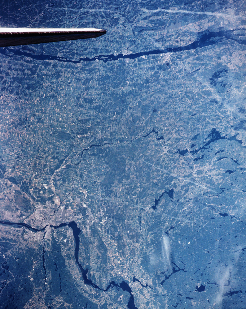
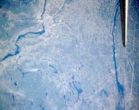
Image Caption: STS085-506-077 East Ontario, Canada August 1997
At this small scale the location of the capital of Canada-Ottawa-in eastern Ontario can be discerned at the junction of three rivers: the dark, broad, winding, Ottawa River; the much narrower Gatineau River (dark, north-south oriented feature); and the Rideau River (thin, dark line that extends southward from Ottawa) in the upper left quadrant of the image. The Rideau River is part of the Rideau Canal Waterway that extends from Ottawa to Kingston, Ontario. The total length of the waterway is 125 miles (202 kilometers). This picture only shows two thirds of this navigable waterway that includes numerous lakes and locks, as well as the Rideau River. One of the runways (light, linear feature) of Ottawa International Airport is discernible along the south side of the urban area. The dark, irregular shaped features west and southwest of Ottawa are numerous glacially formed lakes that are mainly situated within darker uniform-looking heavily forested terrain. The wooded Gatineau Mountains in Quebec are visible north of the Ottawa River. The location of Brockville (Ontario) and Ogdensburg (NY) can be identified (lighter colored area) along the St. Lawrence River (dark, linear feature parallel with the Space Shuttle tail). The elongated, whitish looking, wispy features are jet airplane contrails.
At this small scale the location of the capital of Canada-Ottawa-in eastern Ontario can be discerned at the junction of three rivers: the dark, broad, winding, Ottawa River; the much narrower Gatineau River (dark, north-south oriented feature); and the Rideau River (thin, dark line that extends southward from Ottawa) in the upper left quadrant of the image. The Rideau River is part of the Rideau Canal Waterway that extends from Ottawa to Kingston, Ontario. The total length of the waterway is 125 miles (202 kilometers). This picture only shows two thirds of this navigable waterway that includes numerous lakes and locks, as well as the Rideau River. One of the runways (light, linear feature) of Ottawa International Airport is discernible along the south side of the urban area. The dark, irregular shaped features west and southwest of Ottawa are numerous glacially formed lakes that are mainly situated within darker uniform-looking heavily forested terrain. The wooded Gatineau Mountains in Quebec are visible north of the Ottawa River. The location of Brockville (Ontario) and Ogdensburg (NY) can be identified (lighter colored area) along the St. Lawrence River (dark, linear feature parallel with the Space Shuttle tail). The elongated, whitish looking, wispy features are jet airplane contrails.
