STS085-501-14

| NASA Photo ID | STS085-501-14 |
| Focal Length | 250mm |
| Date taken | 1997.08.__ |
| Time taken | GMT |
Cloud masks available for this image:
Spacecraft nadir point:
Photo center point: 22.5° N, 55.0° E
Photo center point by machine learning:
Photo center point: 22.5° N, 55.0° E
Photo center point by machine learning:
Nadir to Photo Center:
Spacecraft Altitude: nautical miles (0km)
Country or Geographic Name: | OMAN |
Features: | WAHIBAH SANDS, OMAN MTS. |
| Features Found Using Machine Learning: | |
Cloud Cover Percentage: | 0 (no clouds present) |
Sun Elevation Angle: | ° |
Sun Azimuth: | ° |
Camera: | Linhof |
Focal Length: | 250mm |
Camera Tilt: | Low Oblique |
Format: | 5046: Kodak, natural color positive, Lumiere 100/5046, ASA 100, standard base |
Film Exposure: | Normal |
| Additional Information | |
| Width | Height | Annotated | Cropped | Purpose | Links |
|---|---|---|---|---|---|
| 4080 pixels | 5224 pixels | No | No | Earth From Space collection | Download Image |
| 499 pixels | 639 pixels | No | No | Earth From Space collection | Download Image |
Download Packaged File
Download a Google Earth KML for this Image
View photo footprint information
Download a GeoTIFF for this photo
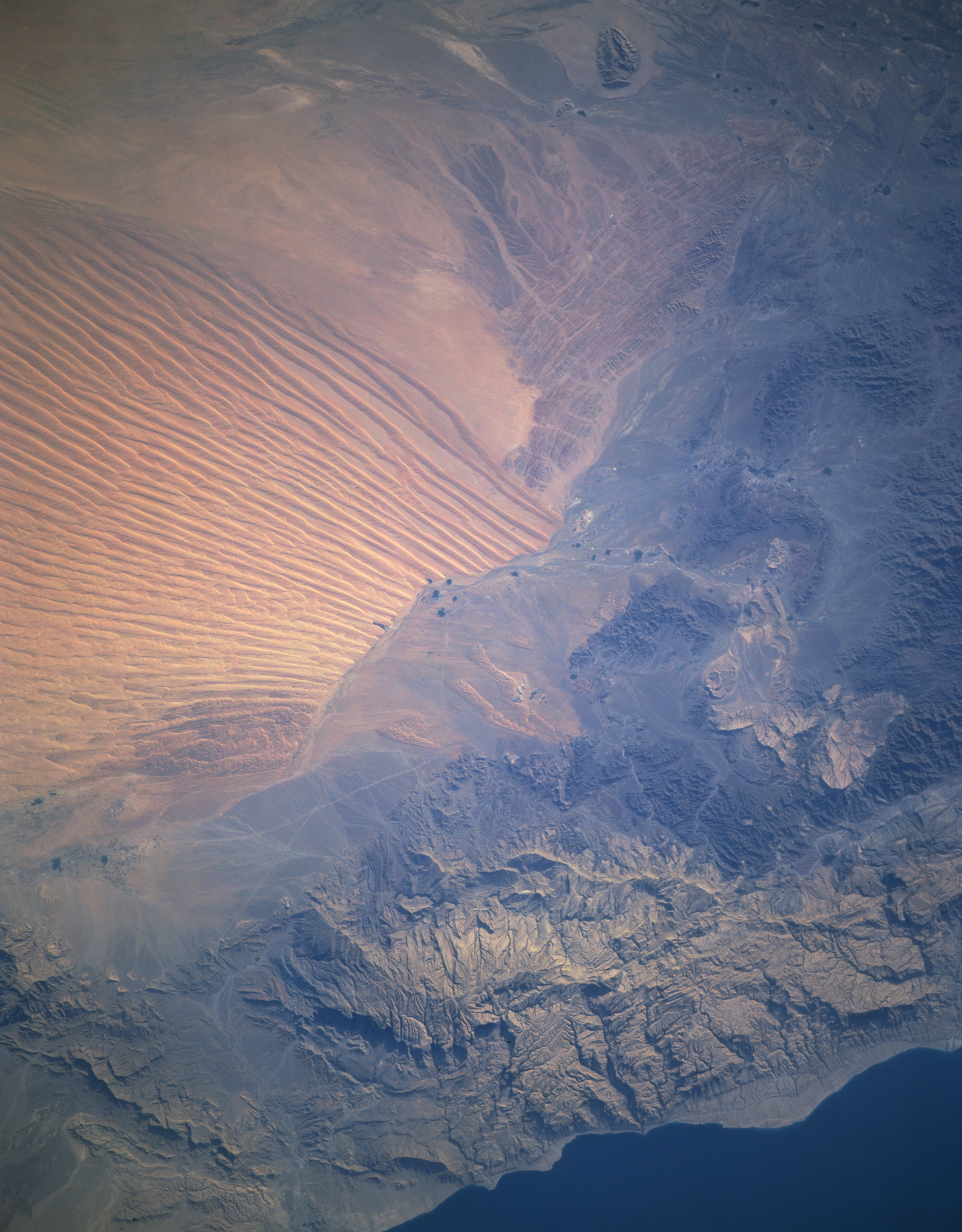
Image Caption: STS085-501-014 Wahiba Sands, Green Mountain Range, Oman August 1997
The eastern extension of the vast Rub-al-Khali Desert or Empty Quarter, the red and golden dunes (650 feet-200 meters) of the Wahiba Sands in southeast Oman (upper left quadrant) is visible in this southwest-looking view. The predominant winds in the area give the longitudinal dunes the north to south alignment. The mountainous terrain that extends diagonally across the bottom of the image is the Al Jabal al Akhdar or Green Mountain Range, which reach altitudes exceeding 5500 feet (1678 meters). Formed nearly 80 million years ago, the range is a large anticline that is flanked by hard limestone and mantle rocks. Monsoon winds bring moisture-laden air in from the Gulf of Oman (bottom right). As the air rises over the Green Mountain Range, the rising air cools, and rainfall occurs at the higher elevations within the range. Several wadis or waterways drain the Green Mountain Range. Forests are scattered throughout the range.
The eastern extension of the vast Rub-al-Khali Desert or Empty Quarter, the red and golden dunes (650 feet-200 meters) of the Wahiba Sands in southeast Oman (upper left quadrant) is visible in this southwest-looking view. The predominant winds in the area give the longitudinal dunes the north to south alignment. The mountainous terrain that extends diagonally across the bottom of the image is the Al Jabal al Akhdar or Green Mountain Range, which reach altitudes exceeding 5500 feet (1678 meters). Formed nearly 80 million years ago, the range is a large anticline that is flanked by hard limestone and mantle rocks. Monsoon winds bring moisture-laden air in from the Gulf of Oman (bottom right). As the air rises over the Green Mountain Range, the rising air cools, and rainfall occurs at the higher elevations within the range. Several wadis or waterways drain the Green Mountain Range. Forests are scattered throughout the range.
