STS083-749-28
| NASA Photo ID | STS083-749-28 |
| Focal Length | 250mm |
| Date taken | 1997.04.07 |
| Time taken | 18:12:09 GMT |
Resolutions offered for this image:
4013 x 4013 pixels 640 x 640 pixels 5700 x 5900 pixels 483 x 500 pixels 506 x 519 pixels 479 x 480 pixels
4013 x 4013 pixels 640 x 640 pixels 5700 x 5900 pixels 483 x 500 pixels 506 x 519 pixels 479 x 480 pixels

Cloud masks available for this image:
Spacecraft nadir point: 28.6° N, 85.7° W
Photo center point: 30.0° N, 85.5° W
Photo center point by machine learning:
Photo center point: 30.0° N, 85.5° W
Photo center point by machine learning:
Nadir to Photo Center: North
Spacecraft Altitude: 159 nautical miles (294km)
Country or Geographic Name: | USA-FLORIDA |
Features: | ST. JOSEPH BAY, CANALS |
| Features Found Using Machine Learning: | |
Cloud Cover Percentage: | 0 (no clouds present) |
Sun Elevation Angle: | 68° |
Sun Azimuth: | 198° |
Camera: | Hasselblad |
Focal Length: | 250mm |
Camera Tilt: | 28 degrees |
Format: | 5069: Kodak Elite 100S, E6 Reversal, Replaces Lumiere, Warmer in tone vs. Lumiere |
Film Exposure: | Normal |
| Additional Information | |
| Width | Height | Annotated | Cropped | Purpose | Links |
|---|---|---|---|---|---|
| 4013 pixels | 4013 pixels | No | No | Earth From Space collection | Download Image |
| 640 pixels | 640 pixels | No | No | Earth From Space collection | Download Image |
| 5700 pixels | 5900 pixels | No | No | Download Image | |
| 483 pixels | 500 pixels | No | No | Download Image | |
| 506 pixels | 519 pixels | No | No | Download Image | |
| 479 pixels | 480 pixels | Download Image |
Download Packaged File
Download a Google Earth KML for this Image
View photo footprint information
Download a GeoTIFF for this photo
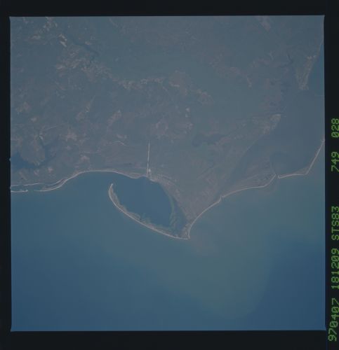
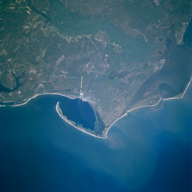
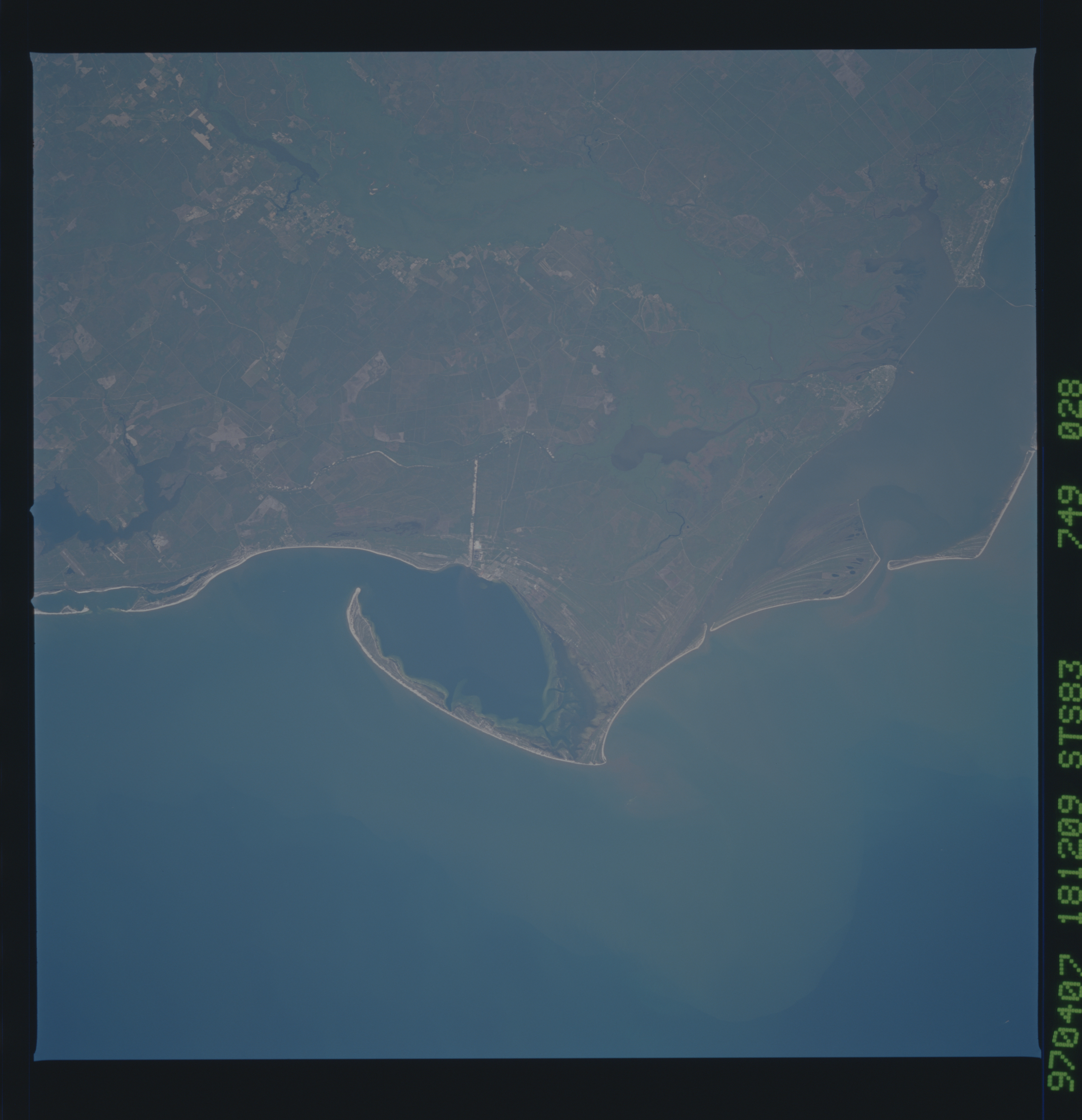
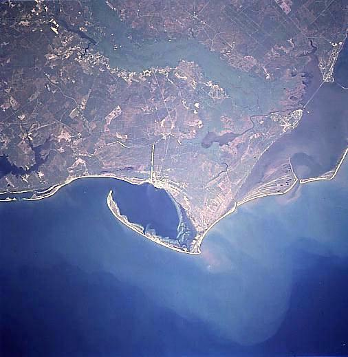
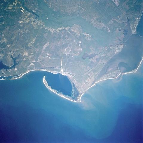
Image Caption: STS083-749-028 Cape San Blas, Florida April, 1997
The Apalachicola Estuary complex and Cape San Blas can be seen in this east-northeast-looking low oblique view. The Apalachicola Estuary is a shallow coastal plain estuary or coastal lagoon that was formed nearly 10000 years ago. The present barrier island system has been in place for the last 5000 years. Just to the right of the center of the image is Saint Vincent Island, a national Wildlife Refuge that covers an area of 19 sq. miles (49 sq. km). Immediately to the right (east) of Saint Vincent is Saint George Island, a narrow barrier island consisting of numerous beaches, sandy coves, salt marshes, and pine and oak forests. To the left (west) of Saint Vincent Island are Cape San Blas and the Saint Joseph Peninsula. The Saint Joseph Peninsula has numerous white sand beaches, dune formations, and a forested interior. The Gulf of Mexico covers the bottom one-third of the image.
The Apalachicola Estuary complex and Cape San Blas can be seen in this east-northeast-looking low oblique view. The Apalachicola Estuary is a shallow coastal plain estuary or coastal lagoon that was formed nearly 10000 years ago. The present barrier island system has been in place for the last 5000 years. Just to the right of the center of the image is Saint Vincent Island, a national Wildlife Refuge that covers an area of 19 sq. miles (49 sq. km). Immediately to the right (east) of Saint Vincent is Saint George Island, a narrow barrier island consisting of numerous beaches, sandy coves, salt marshes, and pine and oak forests. To the left (west) of Saint Vincent Island are Cape San Blas and the Saint Joseph Peninsula. The Saint Joseph Peninsula has numerous white sand beaches, dune formations, and a forested interior. The Gulf of Mexico covers the bottom one-third of the image.
