STS081-742-71
| NASA Photo ID | STS081-742-71 |
| Focal Length | 100mm |
| Date taken | 1997.01.20 |
| Time taken | 18:13:11 GMT |
Resolutions offered for this image:
4072 x 4096 pixels 636 x 640 pixels 5700 x 5900 pixels 483 x 500 pixels
4072 x 4096 pixels 636 x 640 pixels 5700 x 5900 pixels 483 x 500 pixels


Cloud masks available for this image:
Spacecraft nadir point: 36.8° S, 70.3° W
Photo center point: 37.5° S, 71.5° W
Photo center point by machine learning:
Photo center point: 37.5° S, 71.5° W
Photo center point by machine learning:
Nadir to Photo Center: Southwest
Spacecraft Altitude: 205 nautical miles (380km)
Camera: | Hasselblad |
Focal Length: | 100mm |
Camera Tilt: | 22 degrees |
Format: | 2443: Kodak Aerochrome 2443, color IR, thin base, EA-5 process thru June 1999, E-6 process afterward |
Film Exposure: | Normal |
| Additional Information | |
| Width | Height | Annotated | Cropped | Purpose | Links |
|---|---|---|---|---|---|
| 4072 pixels | 4096 pixels | No | No | Earth From Space collection | Download Image |
| 636 pixels | 640 pixels | No | No | Earth From Space collection | Download Image |
| 5700 pixels | 5900 pixels | No | No | Download Image | |
| 483 pixels | 500 pixels | No | No | Download Image |
Download Packaged File
Download a Google Earth KML for this Image
View photo footprint information
Download a GeoTIFF for this photo
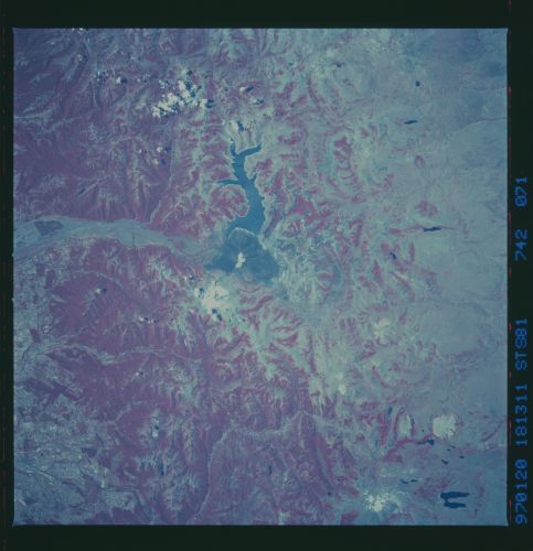
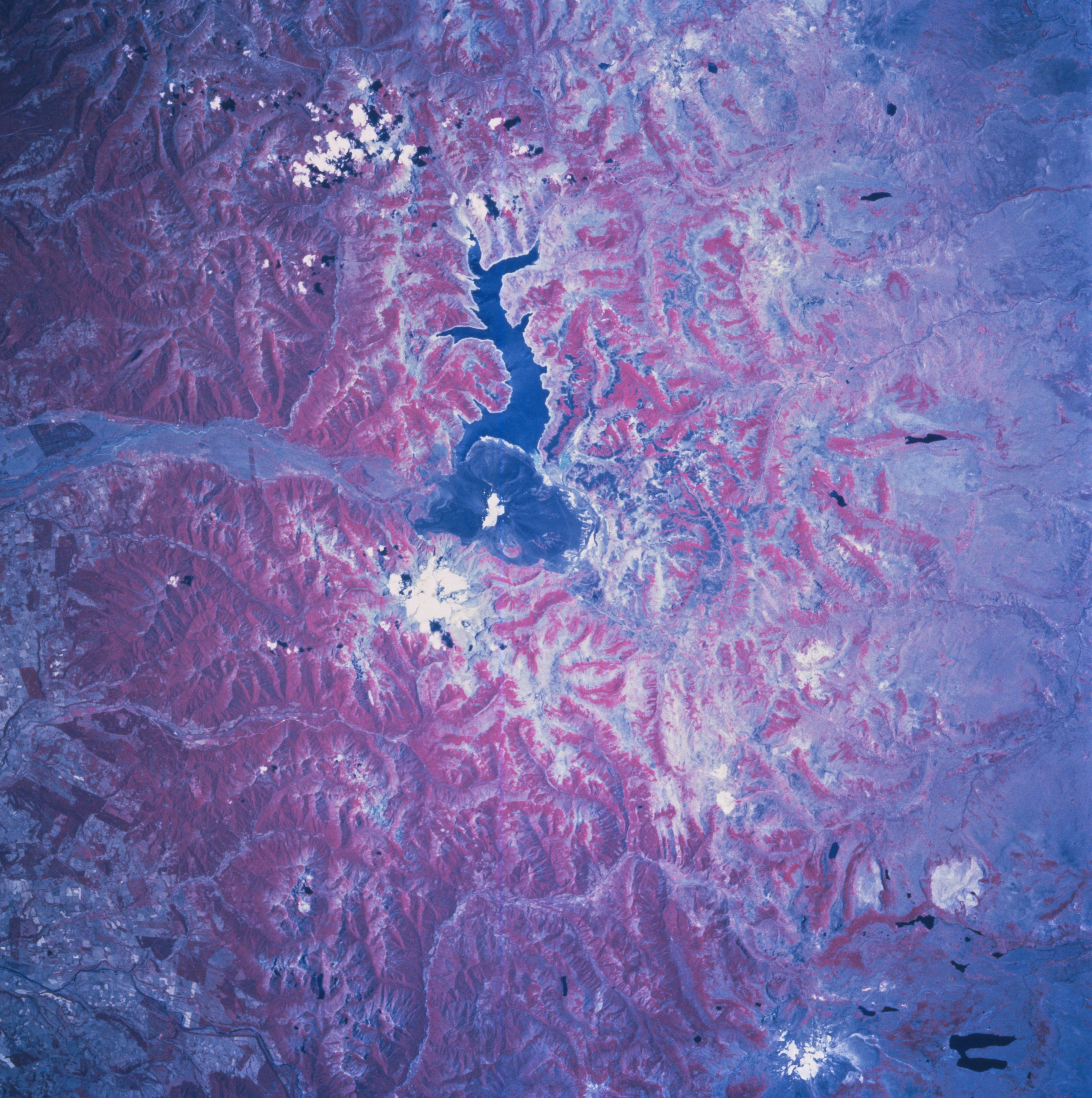
Image Caption: STS081-742-071 Laguna de la Laja, Chile January 1997
Laguna de la Laja is the sinuous dark feature in the middle of this color infrared image of the Andes range east of Los Angeles, Chile. From a hydroelectric generating station at the southwest end of the reservoir, Rio Laja flows westward down a broad valley cut through the Andes. The rough-textured, dark, arcuate feature at the south end of the reservoir is a large lava field. The amount of vegetative cover differs dramatically between the east and the west slopes of the Andes. This image illustrates the "rain shadow effect" where moisture-bearing westerly winds off the Pacific cross the mountains and produce well-watered, densely forested western slopes (deeper red indicates heavier vegetation). The eastern slopes receive less moisture and are less vegetated, thus the gradation from deep red to lighter pink from west to east across the color infrared image. The dark, U-shaped feature in the bottom right corner is Lago Agrio and the lighter colored feature immediately west of this lake is Copahue Volcano.
Laguna de la Laja is the sinuous dark feature in the middle of this color infrared image of the Andes range east of Los Angeles, Chile. From a hydroelectric generating station at the southwest end of the reservoir, Rio Laja flows westward down a broad valley cut through the Andes. The rough-textured, dark, arcuate feature at the south end of the reservoir is a large lava field. The amount of vegetative cover differs dramatically between the east and the west slopes of the Andes. This image illustrates the "rain shadow effect" where moisture-bearing westerly winds off the Pacific cross the mountains and produce well-watered, densely forested western slopes (deeper red indicates heavier vegetation). The eastern slopes receive less moisture and are less vegetated, thus the gradation from deep red to lighter pink from west to east across the color infrared image. The dark, U-shaped feature in the bottom right corner is Lago Agrio and the lighter colored feature immediately west of this lake is Copahue Volcano.
