STS081-742-30
| NASA Photo ID | STS081-742-30 |
| Focal Length | 250mm |
| Date taken | 1997.01.20 |
| Time taken | 16:25:56 GMT |
Resolutions offered for this image:
4012 x 4012 pixels 639 x 639 pixels 5700 x 5900 pixels 483 x 500 pixels 523 x 485 pixels
4012 x 4012 pixels 639 x 639 pixels 5700 x 5900 pixels 483 x 500 pixels 523 x 485 pixels


Cloud masks available for this image:
Spacecraft nadir point: 8.9° N, 86.1° W
Photo center point: 10.0° N, 85.0° W
Photo center point by machine learning:
Photo center point: 10.0° N, 85.0° W
Photo center point by machine learning:
Nadir to Photo Center: Northeast
Spacecraft Altitude: 193 nautical miles (357km)
Country or Geographic Name: | COSTA RICA |
Features: | NICOYA PENINSULA |
| Features Found Using Machine Learning: | |
Cloud Cover Percentage: | 0 (no clouds present) |
Sun Elevation Angle: | 54° |
Sun Azimuth: | 143° |
Camera: | Hasselblad |
Focal Length: | 250mm |
Camera Tilt: | 26 degrees |
Format: | 2443: Kodak Aerochrome 2443, color IR, thin base, EA-5 process thru June 1999, E-6 process afterward |
Film Exposure: | Normal |
| Additional Information | |
| Width | Height | Annotated | Cropped | Purpose | Links |
|---|---|---|---|---|---|
| 4012 pixels | 4012 pixels | No | No | Earth From Space collection | Download Image |
| 639 pixels | 639 pixels | No | No | Earth From Space collection | Download Image |
| 5700 pixels | 5900 pixels | No | No | Download Image | |
| 483 pixels | 500 pixels | No | No | Download Image | |
| 523 pixels | 485 pixels | No | No | Download Image |
Download Packaged File
Download a Google Earth KML for this Image
View photo footprint information
Download a GeoTIFF for this photo
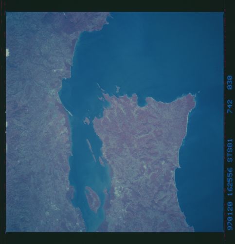
Image Caption: STS081-742-030 Nicoya Gulf, Peninsula, Costa Rica January 1997
The southern end of the mountainous Nicoya Peninsula extends southeasterly separating the waters of the Pacific Ocean from the Gulf of Nicoya. The color infrared image helps to document the numerous vegetated hills and valleys (red colors represent green plants) both on the peninsula as well as on the mainland. The deeper reds tend to show either dense stands of rainforest or in the coastal zone, they represent mangrove forests. The small estuary of the Rio Grande de Tarcoles is barely discernible near the upper right edge (southeast corner) of the image. Chira Island is the large island in the Gulf of Nicoya. (Refer to STS81-742-028 and STS81-742-029 for other color infrared pictures of the Nicoya Peninsula).
The southern end of the mountainous Nicoya Peninsula extends southeasterly separating the waters of the Pacific Ocean from the Gulf of Nicoya. The color infrared image helps to document the numerous vegetated hills and valleys (red colors represent green plants) both on the peninsula as well as on the mainland. The deeper reds tend to show either dense stands of rainforest or in the coastal zone, they represent mangrove forests. The small estuary of the Rio Grande de Tarcoles is barely discernible near the upper right edge (southeast corner) of the image. Chira Island is the large island in the Gulf of Nicoya. (Refer to STS81-742-028 and STS81-742-029 for other color infrared pictures of the Nicoya Peninsula).
