STS081-742-27
| NASA Photo ID | STS081-742-27 |
| Focal Length | 250mm |
| Date taken | 1997.01.20 |
| Time taken | 16:25:49 GMT |
Resolutions offered for this image:
4096 x 4096 pixels 640 x 640 pixels 5700 x 5900 pixels 483 x 500 pixels 498 x 499 pixels
4096 x 4096 pixels 640 x 640 pixels 5700 x 5900 pixels 483 x 500 pixels 498 x 499 pixels


Cloud masks available for this image:
Spacecraft nadir point: 9.3° N, 86.4° W
Photo center point: 10.5° N, 84.5° W
Photo center point by machine learning:
Photo center point: 10.5° N, 84.5° W
Photo center point by machine learning:
Nadir to Photo Center: Northeast
Spacecraft Altitude: 193 nautical miles (357km)
Country or Geographic Name: | COSTA RICA |
Features: | ARENAL VOLCANO |
| Features Found Using Machine Learning: | |
Cloud Cover Percentage: | 20 (11-25)% |
Sun Elevation Angle: | 53° |
Sun Azimuth: | 143° |
Camera: | Hasselblad |
Focal Length: | 250mm |
Camera Tilt: | 35 degrees |
Format: | 2443: Kodak Aerochrome 2443, color IR, thin base, EA-5 process thru June 1999, E-6 process afterward |
Film Exposure: | Normal |
| Additional Information | |
| Width | Height | Annotated | Cropped | Purpose | Links |
|---|---|---|---|---|---|
| 4096 pixels | 4096 pixels | No | No | Earth From Space collection | Download Image |
| 640 pixels | 640 pixels | No | No | Earth From Space collection | Download Image |
| 5700 pixels | 5900 pixels | No | No | Download Image | |
| 483 pixels | 500 pixels | No | No | Download Image | |
| 498 pixels | 499 pixels | No | No | Download Image |
Download Packaged File
Download a Google Earth KML for this Image
View photo footprint information
Download a GeoTIFF for this photo
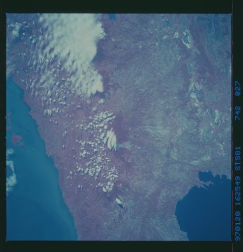
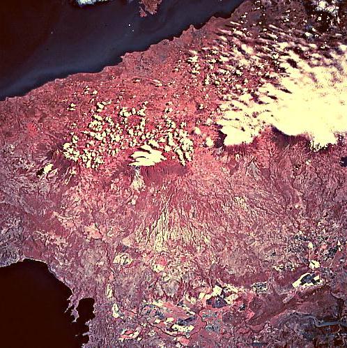
Image Caption: STS081-742-027 Guanacaste Mountains, Costa Rica January 1997
The color infrared image helps to identify three major volcanoes that are part of the Guanacaste Mountains (volcanic range of mountains) in northwest Costa Rica. With many of the volcanic summits being covered by clouds, the deep red colors of the heavily forested slopes of the volcanoes line up in a northwest to southeast alignment. From left to right across the picture the names of the volcanoes are Orosi, Rincon de la Vieja (center of image), and Miravalles. The western flanks of these volcanoes exhibit a severely eroded landscape that grades into the Tempisque River Basin, located southwest of the mountains. This basin is an extensive fertile plain, but during the wet season the Tempisque River can inundate its floodplain and adjacent low-lying terrain. As the river approaches the Gulf of Nicoya, saline lagoons and swamplands increase, forming extensive wetlands. On higher elevations within the Tempisque Basin large field patterns, consisting of ranches and plantations are visible near the bottom of the picture. The darker feature at the top of the picture is the southern end of Lake Nicaragua and the dark feature in the lower left corner of the image is the Gulf of Papagayo.
The color infrared image helps to identify three major volcanoes that are part of the Guanacaste Mountains (volcanic range of mountains) in northwest Costa Rica. With many of the volcanic summits being covered by clouds, the deep red colors of the heavily forested slopes of the volcanoes line up in a northwest to southeast alignment. From left to right across the picture the names of the volcanoes are Orosi, Rincon de la Vieja (center of image), and Miravalles. The western flanks of these volcanoes exhibit a severely eroded landscape that grades into the Tempisque River Basin, located southwest of the mountains. This basin is an extensive fertile plain, but during the wet season the Tempisque River can inundate its floodplain and adjacent low-lying terrain. As the river approaches the Gulf of Nicoya, saline lagoons and swamplands increase, forming extensive wetlands. On higher elevations within the Tempisque Basin large field patterns, consisting of ranches and plantations are visible near the bottom of the picture. The darker feature at the top of the picture is the southern end of Lake Nicaragua and the dark feature in the lower left corner of the image is the Gulf of Papagayo.
