STS081-724-89

| NASA Photo ID | STS081-724-89 |
| Focal Length | 250mm |
| Date taken | 1997.01.__ |
| Time taken | GMT |
Resolutions offered for this image:
4096 x 4096 pixels 640 x 640 pixels 5700 x 5900 pixels 483 x 500 pixels
4096 x 4096 pixels 640 x 640 pixels 5700 x 5900 pixels 483 x 500 pixels


Cloud masks available for this image:
Spacecraft nadir point:
Photo center point: 45.5° S, 69.0° W
Photo center point by machine learning:
Photo center point: 45.5° S, 69.0° W
Photo center point by machine learning:
Nadir to Photo Center:
Spacecraft Altitude: nautical miles (0km)
Country or Geographic Name: | ARGENTINA |
Features: | L. MUSTERS &COLHUE HUAPI |
| Features Found Using Machine Learning: | |
Cloud Cover Percentage: | 0 (no clouds present) |
Sun Elevation Angle: | ° |
Sun Azimuth: | ° |
Camera: | Hasselblad |
Focal Length: | 250mm |
Camera Tilt: | |
Format: | 5046: Kodak, natural color positive, Lumiere 100/5046, ASA 100, standard base |
Film Exposure: | Normal |
| Additional Information | |
| Width | Height | Annotated | Cropped | Purpose | Links |
|---|---|---|---|---|---|
| 4096 pixels | 4096 pixels | No | No | Earth From Space collection | Download Image |
| 640 pixels | 640 pixels | No | No | Earth From Space collection | Download Image |
| 5700 pixels | 5900 pixels | No | No | Download Image | |
| 483 pixels | 500 pixels | No | No | Download Image |
Download Packaged File
Download a Google Earth KML for this Image
View photo footprint information
Download a GeoTIFF for this photo
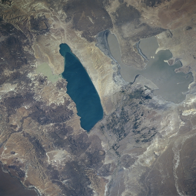
Image Caption: STS081-724-089 Lakes Musters and Colhue Huapi, Argentina January 1997
The deeper blue waters of Lake Musters and the shallow silt-laden waters of Lake Colhue Huapi can be seen in this view. The lakes are situated on the semi-arid, windswept Patagonian Plateau approximately 75 miles (121 km) west of Argentina's major oil-producing port city, Comodoro Rivadavia. Just to the south of Lake Musters is the delta of the Senguerr River, which appears as a dark line entering half way down the left side of the view. The river feeds both lakes. The Senguerr River begins its journey from the glacial lakes of La Plata and Fontana in the Andes Mountains. The river flows generally eastward, then circles around the southern end of the San Bernardo Mountains (dark area upper left and center) and flows North-northeastward to form the delta. Water is discharged into the lakes, and thus lake levels vary with the season and annual climate. Lake Musters is drained near lake's southeastern end by a small stream. The stream flows into western Lake Colhue Huapi. Colhue Huapi is drained near its eastern end by the Chico River. The Chico then flows generally northeastward and empties into the Chubut River. The small city of Sarmiento (barely discernible) is located midway between the two lakes at the northern end of the delta region.
The deeper blue waters of Lake Musters and the shallow silt-laden waters of Lake Colhue Huapi can be seen in this view. The lakes are situated on the semi-arid, windswept Patagonian Plateau approximately 75 miles (121 km) west of Argentina's major oil-producing port city, Comodoro Rivadavia. Just to the south of Lake Musters is the delta of the Senguerr River, which appears as a dark line entering half way down the left side of the view. The river feeds both lakes. The Senguerr River begins its journey from the glacial lakes of La Plata and Fontana in the Andes Mountains. The river flows generally eastward, then circles around the southern end of the San Bernardo Mountains (dark area upper left and center) and flows North-northeastward to form the delta. Water is discharged into the lakes, and thus lake levels vary with the season and annual climate. Lake Musters is drained near lake's southeastern end by a small stream. The stream flows into western Lake Colhue Huapi. Colhue Huapi is drained near its eastern end by the Chico River. The Chico then flows generally northeastward and empties into the Chubut River. The small city of Sarmiento (barely discernible) is located midway between the two lakes at the northern end of the delta region.
