STS079-835-65

| NASA Photo ID | STS079-835-65 |
| Focal Length | 100mm |
| Date taken | 1996.09.21 |
| Time taken | 03:32:54 GMT |
Resolutions offered for this image:
4096 x 4096 pixels 640 x 640 pixels 5700 x 5900 pixels 483 x 500 pixels 519 x 510 pixels
4096 x 4096 pixels 640 x 640 pixels 5700 x 5900 pixels 483 x 500 pixels 519 x 510 pixels


Cloud masks available for this image:
Spacecraft nadir point: 42.1° S, 172.2° E
Photo center point: 45.5° S, 170.0° E
Photo center point by machine learning:
Photo center point: 45.5° S, 170.0° E
Photo center point by machine learning:
Nadir to Photo Center: Southwest
Spacecraft Altitude: 207 nautical miles (383km)
Country or Geographic Name: | NEW ZEALAND-SI |
Features: | S. ALPS WAITAKI RIVER |
| Features Found Using Machine Learning: | |
Cloud Cover Percentage: | 20 (11-25)% |
Sun Elevation Angle: | 30° |
Sun Azimuth: | 302° |
Camera: | Hasselblad |
Focal Length: | 100mm |
Camera Tilt: | 50 degrees |
Format: | 5046: Kodak, natural color positive, Lumiere 100/5046, ASA 100, standard base |
Film Exposure: | Normal |
| Additional Information | |
| Width | Height | Annotated | Cropped | Purpose | Links |
|---|---|---|---|---|---|
| 4096 pixels | 4096 pixels | No | No | Earth From Space collection | Download Image |
| 640 pixels | 640 pixels | No | No | Earth From Space collection | Download Image |
| 5700 pixels | 5900 pixels | No | No | Download Image | |
| 483 pixels | 500 pixels | No | No | Download Image | |
| 519 pixels | 510 pixels | No | No | Download Image |
Download Packaged File
Download a Google Earth KML for this Image
View photo footprint information
Download a GeoTIFF for this photo
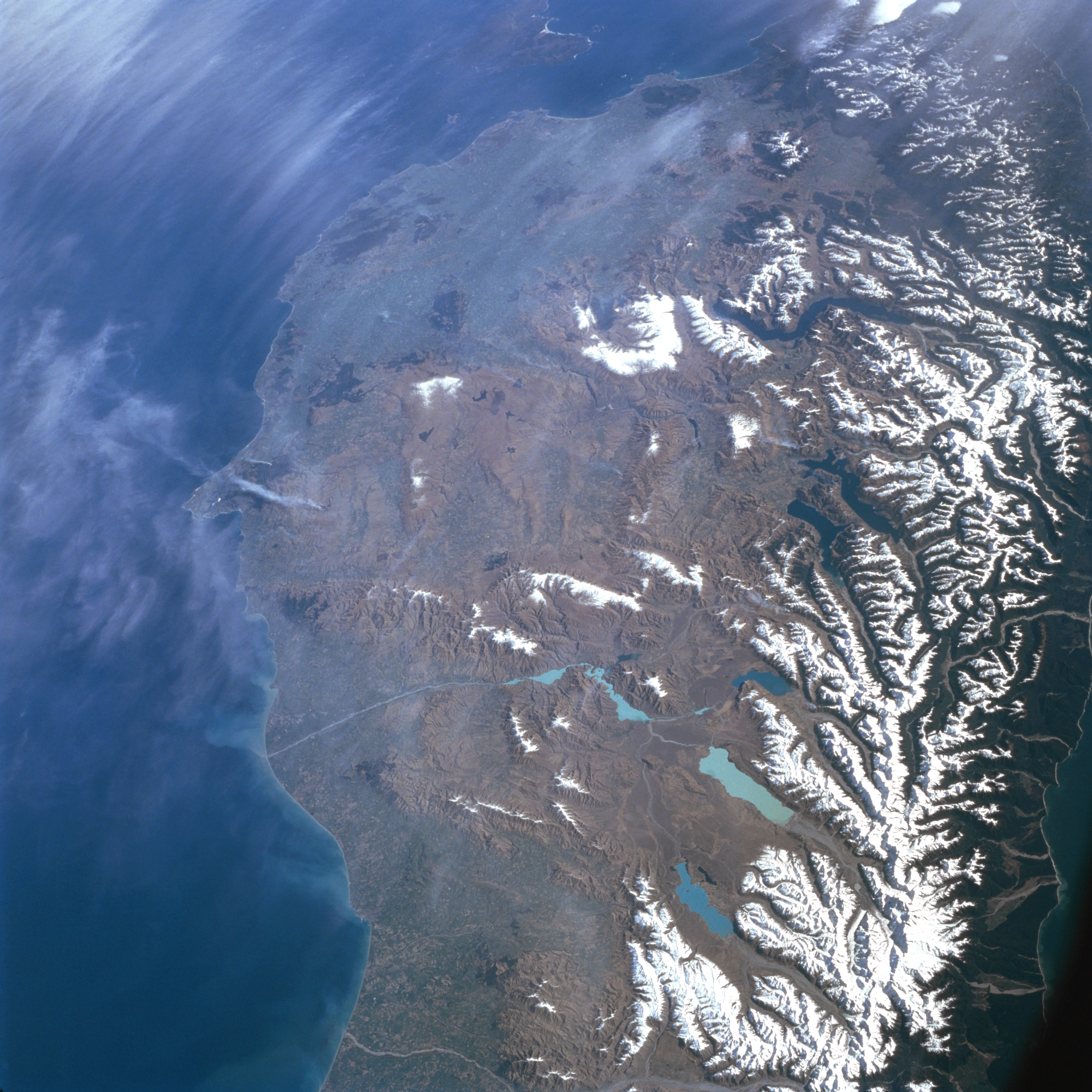
Image Caption: STS079-835-065 Southern Alps, South Island, New Zealand September 1996
This southwest-looking view shows most of southern South Island, New Zealand. Along the right (west) margin of the image, the snow-covered Southern Alps are visible. The Southern Alps parallel the western coast of South Island. The southwest-northeast trending range has 17 peaks higher than 9842 feet (3000 meters) including Mount Cook (Aorangi) at 12316 feet (3754 meters), the tallest peak in New Zealand. There are more than 3100 active glaciers in the Southern Alps. West (right) of the Southern Alps there is little or no coastal plain. Along the west coast, steep-sided valleys and fiords are the prevailing landscape. East (left) of the Alps are extensive foothills and glaciated valleys, many occupied by deep freshwater lakes. There are also large areas that are covered with a glacial fluvial outwash of sand and gravel, and a number of intricately braided rivers. Along the east coast near the bottom left of the image is the Cantebury Plain, the largest area of fertile flat land in New Zealand. The southeastern part of the island near the upper center of the image is an irregular dissected section of land that consists of small plains and basins surrounded by hills. At the upper center of the image, Stewart Island is discernible.
This southwest-looking view shows most of southern South Island, New Zealand. Along the right (west) margin of the image, the snow-covered Southern Alps are visible. The Southern Alps parallel the western coast of South Island. The southwest-northeast trending range has 17 peaks higher than 9842 feet (3000 meters) including Mount Cook (Aorangi) at 12316 feet (3754 meters), the tallest peak in New Zealand. There are more than 3100 active glaciers in the Southern Alps. West (right) of the Southern Alps there is little or no coastal plain. Along the west coast, steep-sided valleys and fiords are the prevailing landscape. East (left) of the Alps are extensive foothills and glaciated valleys, many occupied by deep freshwater lakes. There are also large areas that are covered with a glacial fluvial outwash of sand and gravel, and a number of intricately braided rivers. Along the east coast near the bottom left of the image is the Cantebury Plain, the largest area of fertile flat land in New Zealand. The southeastern part of the island near the upper center of the image is an irregular dissected section of land that consists of small plains and basins surrounded by hills. At the upper center of the image, Stewart Island is discernible.
