STS079-834-66

| NASA Photo ID | STS079-834-66 |
| Focal Length | 250mm |
| Date taken | 1996.09.19 |
| Time taken | 15:45:13 GMT |
Resolutions offered for this image:
4019 x 4019 pixels 640 x 640 pixels 5700 x 5900 pixels 483 x 500 pixels 505 x 480 pixels 479 x 479 pixels
4019 x 4019 pixels 640 x 640 pixels 5700 x 5900 pixels 483 x 500 pixels 505 x 480 pixels 479 x 479 pixels


Cloud masks available for this image:
Spacecraft nadir point: 39.4° N, 87.3° W
Photo center point: 42.0° N, 90.5° W
Photo center point by machine learning:
Photo center point: 42.0° N, 90.5° W
Photo center point by machine learning:
Nadir to Photo Center: Northwest
Spacecraft Altitude: 202 nautical miles (374km)
Country or Geographic Name: | USA-IOWA |
Features: | MISSISSIPPI R., CLINTON |
| Features Found Using Machine Learning: | |
Cloud Cover Percentage: | 0 (no clouds present) |
Sun Elevation Angle: | 44° |
Sun Azimuth: | 137° |
Camera: | Hasselblad |
Focal Length: | 250mm |
Camera Tilt: | 51 degrees |
Format: | 5046: Kodak, natural color positive, Lumiere 100/5046, ASA 100, standard base |
Film Exposure: | Normal |
| Additional Information | |
| Width | Height | Annotated | Cropped | Purpose | Links |
|---|---|---|---|---|---|
| 4019 pixels | 4019 pixels | No | No | Earth From Space collection | Download Image |
| 640 pixels | 640 pixels | No | No | Earth From Space collection | Download Image |
| 5700 pixels | 5900 pixels | No | No | Download Image | |
| 483 pixels | 500 pixels | No | No | Download Image | |
| 505 pixels | 480 pixels | No | No | Download Image | |
| 479 pixels | 479 pixels | Download Image |
Download Packaged File
Download a Google Earth KML for this Image
View photo footprint information
Download a GeoTIFF for this photo
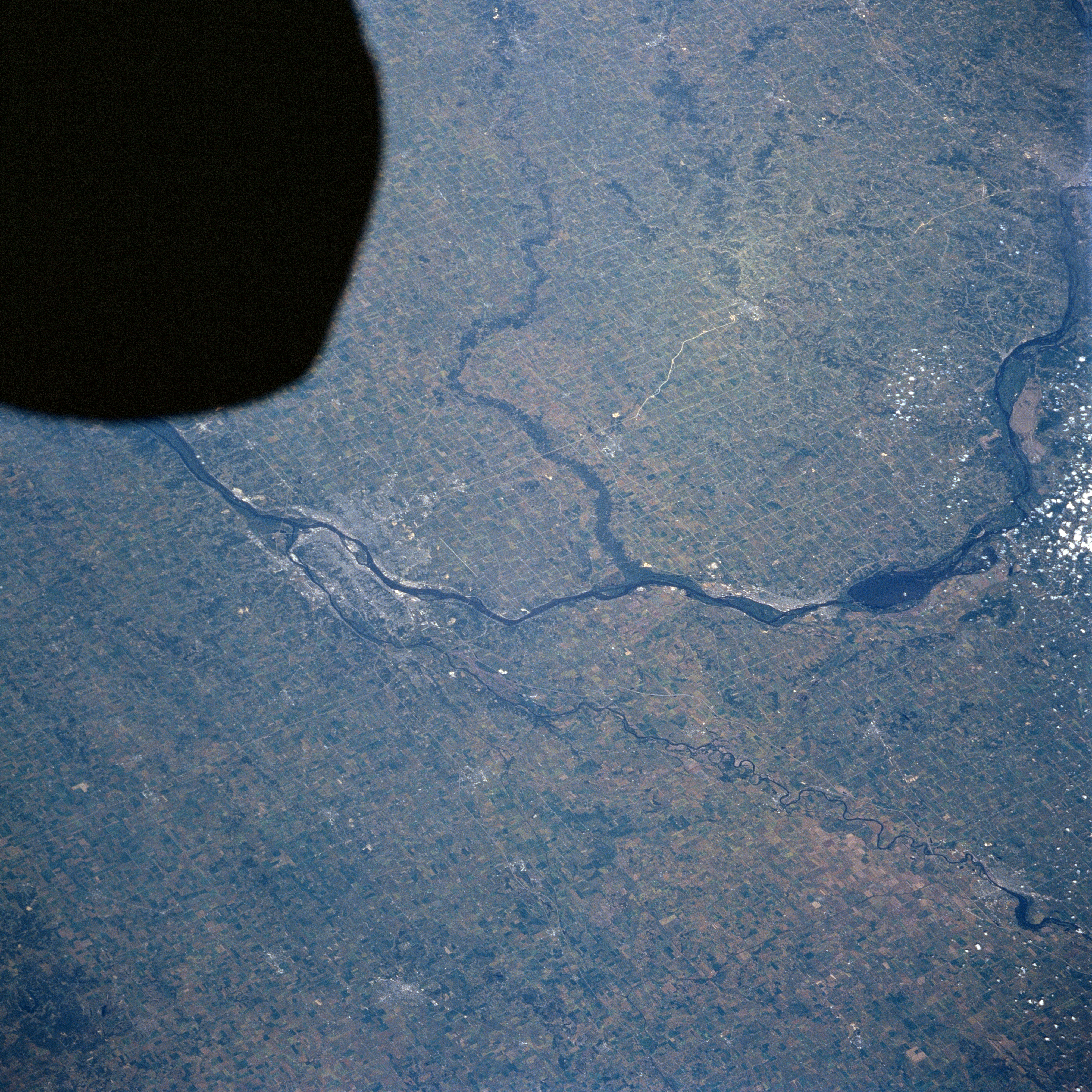
Image Caption: STS079-834-066 Quad Cities, Mississippi River, Iowa September, 1996
This north-northwest-looking view shows the Mississippi River, Clinton, Iowa, and the Quad Cities area of western Illinois and northeast Iowa. Just below the top right of the image, the Mississippi River travels southeastward to just north of Clinton, Iowa, where the river turns to the south. At Clinton, the river makes a turn to the southwest and then to the west as it passes the Quad Cities and exits the frame at the dark area on the image. The Quad Cities are made up of Davenport, Iowa, on the north bank of the Mississippi River, and East Moline, Moline, and Rock Island, Illinois, on the south bank of the Mississippi River. The Wapsipinicon River traverses the scene from the top center of the image near Anamosa, Iowa, and travels in a generally east-southeast direction entering the Mississippi near the center of the image. The Rock River enters the scene just above the bottom right of the image near Sterling, Illinois, and flows generally in a southwest direction entering the Mississippi River just to the west of the Quad Cities.
This north-northwest-looking view shows the Mississippi River, Clinton, Iowa, and the Quad Cities area of western Illinois and northeast Iowa. Just below the top right of the image, the Mississippi River travels southeastward to just north of Clinton, Iowa, where the river turns to the south. At Clinton, the river makes a turn to the southwest and then to the west as it passes the Quad Cities and exits the frame at the dark area on the image. The Quad Cities are made up of Davenport, Iowa, on the north bank of the Mississippi River, and East Moline, Moline, and Rock Island, Illinois, on the south bank of the Mississippi River. The Wapsipinicon River traverses the scene from the top center of the image near Anamosa, Iowa, and travels in a generally east-southeast direction entering the Mississippi near the center of the image. The Rock River enters the scene just above the bottom right of the image near Sterling, Illinois, and flows generally in a southwest direction entering the Mississippi River just to the west of the Quad Cities.
