STS079-810-49
| NASA Photo ID | STS079-810-49 |
| Focal Length | 250mm |
| Date taken | 1996.09.24 |
| Time taken | 06:20:34 GMT |
Resolutions offered for this image:
4096 x 4066 pixels 640 x 635 pixels 5700 x 5900 pixels 483 x 500 pixels 648 x 641 pixels
4096 x 4066 pixels 640 x 635 pixels 5700 x 5900 pixels 483 x 500 pixels 648 x 641 pixels


Cloud masks available for this image:
Spacecraft nadir point: 33.9° N, 34.3° E
Photo center point: 33.0° N, 35.0° E
Photo center point by machine learning:
Photo center point: 33.0° N, 35.0° E
Photo center point by machine learning:
Nadir to Photo Center: Southeast
Spacecraft Altitude: 201 nautical miles (372km)
Country or Geographic Name: | ISRAEL |
Features: | HAIFA, LAKE TIBERIAS |
| Features Found Using Machine Learning: | |
Cloud Cover Percentage: | 0 (no clouds present) |
Sun Elevation Angle: | 33° |
Sun Azimuth: | 117° |
Camera: | Hasselblad |
Focal Length: | 250mm |
Camera Tilt: | 19 degrees |
Format: | 5046: Kodak, natural color positive, Lumiere 100/5046, ASA 100, standard base |
Film Exposure: | Normal |
| Additional Information | |
| Width | Height | Annotated | Cropped | Purpose | Links |
|---|---|---|---|---|---|
| 4096 pixels | 4066 pixels | No | No | Earth From Space collection | Download Image |
| 640 pixels | 635 pixels | No | No | Earth From Space collection | Download Image |
| 5700 pixels | 5900 pixels | No | No | Download Image | |
| 483 pixels | 500 pixels | No | No | Download Image | |
| 648 pixels | 641 pixels | No | No | Download Image |
Download Packaged File
Download a Google Earth KML for this Image
View photo footprint information
Download a GeoTIFF for this photo
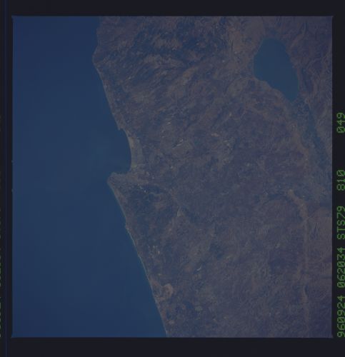
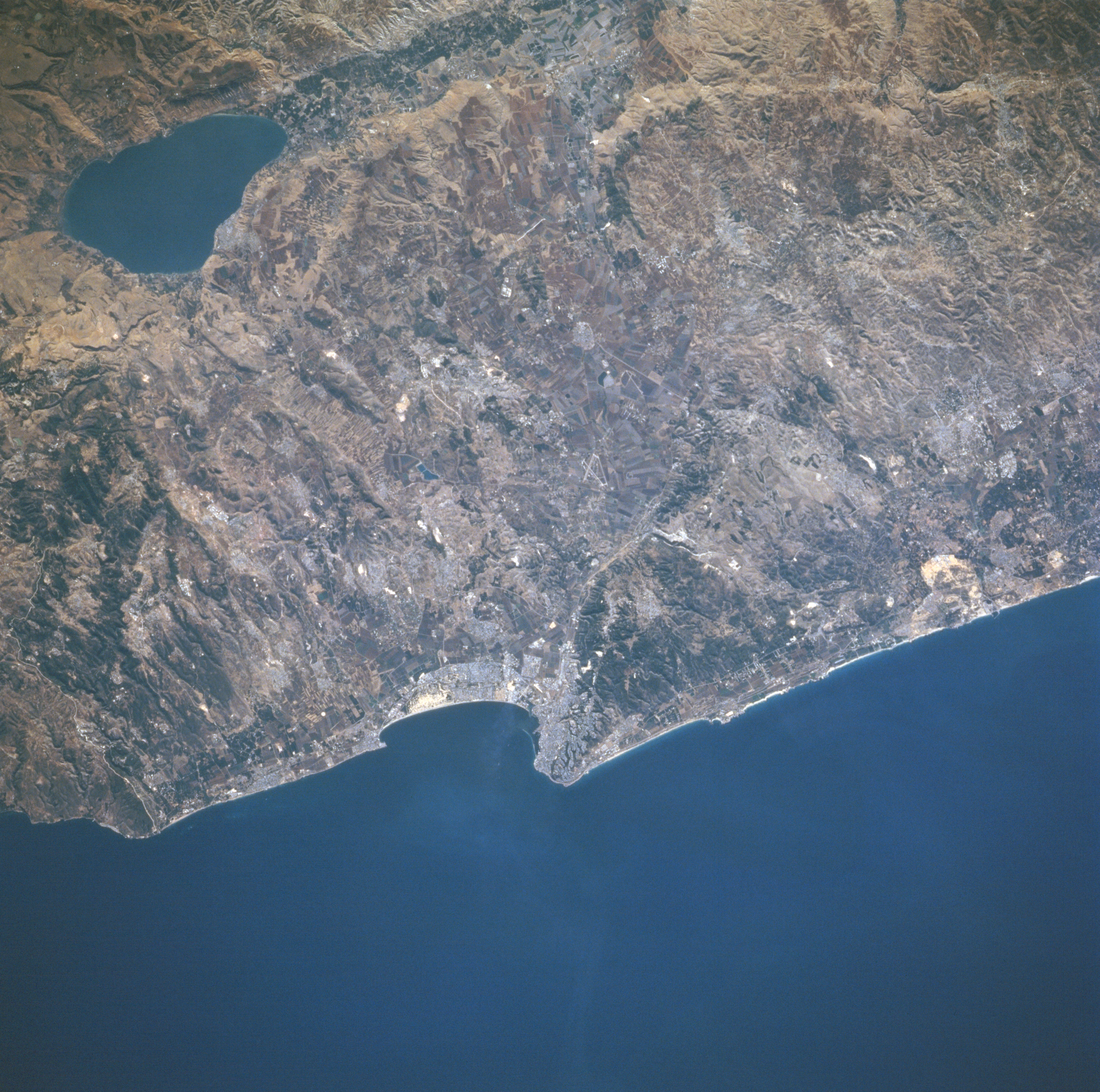
Image Caption: STS079-810-049 Haifa, Lake Tiberias, Israel September 1996
The third largest city in Israel, the coastal city of Haifa, situated midway between the center and bottom center of the image, is visible in this southeast-looking view. Haifa is the main port of Israel and is the country's industrial center as well. Major industries include oil refineries, food processing, shipbuilding, chemicals, electrical equipment, steel, and textiles. In the upper left corner of the image, the pear-shaped freshwater Lake Tiberias (Sea of Galilee) can be seen. Lake Tiberias is 14 miles (23 km) long and has a maximum width of 8 miles (13 km). The lake has a maximum depth of 150 feet (46 meters) and covers an area of 64 square miles (165 square km). Lake Tiberias lies 680 feet (207 meters) below sea level and its bed forms part of the Dead Sea Rift Valley. At one time in the geologic past, Lake Tiberias was part of a great inland sea that extended from the Hula marshes in Northern Israel to a point 40 miles (64 km) south of the Dead Sea. The lake is completely encircled by beach, and bordered by escarpments and plains. Tourism and fishing are the main industries around the lake.
The third largest city in Israel, the coastal city of Haifa, situated midway between the center and bottom center of the image, is visible in this southeast-looking view. Haifa is the main port of Israel and is the country's industrial center as well. Major industries include oil refineries, food processing, shipbuilding, chemicals, electrical equipment, steel, and textiles. In the upper left corner of the image, the pear-shaped freshwater Lake Tiberias (Sea of Galilee) can be seen. Lake Tiberias is 14 miles (23 km) long and has a maximum width of 8 miles (13 km). The lake has a maximum depth of 150 feet (46 meters) and covers an area of 64 square miles (165 square km). Lake Tiberias lies 680 feet (207 meters) below sea level and its bed forms part of the Dead Sea Rift Valley. At one time in the geologic past, Lake Tiberias was part of a great inland sea that extended from the Hula marshes in Northern Israel to a point 40 miles (64 km) south of the Dead Sea. The lake is completely encircled by beach, and bordered by escarpments and plains. Tourism and fishing are the main industries around the lake.
