STS079-785-102

| NASA Photo ID | STS079-785-102 |
| Focal Length | 100mm |
| Date taken | 1996.09.25 |
| Time taken | 14:49:10 GMT |
Resolutions offered for this image:
4067 x 4067 pixels 639 x 639 pixels 5700 x 5900 pixels 483 x 500 pixels
4067 x 4067 pixels 639 x 639 pixels 5700 x 5900 pixels 483 x 500 pixels


Cloud masks available for this image:
Spacecraft nadir point: 10.1° S, 61.0° W
Photo center point: 10.5° S, 62.5° W
Photo center point by machine learning:
Photo center point: 10.5° S, 62.5° W
Photo center point by machine learning:
Nadir to Photo Center: West
Spacecraft Altitude: 200 nautical miles (370km)
Country or Geographic Name: | BRAZIL |
Features: | DEFORESTATION, RIO JAMARI |
| Features Found Using Machine Learning: | |
Cloud Cover Percentage: | 15 (11-25)% |
Sun Elevation Angle: | 71° |
Sun Azimuth: | 63° |
Camera: | Hasselblad |
Focal Length: | 100mm |
Camera Tilt: | 25 degrees |
Format: | 5046: Kodak, natural color positive, Lumiere 100/5046, ASA 100, standard base |
Film Exposure: | Normal |
| Additional Information | |
| Width | Height | Annotated | Cropped | Purpose | Links |
|---|---|---|---|---|---|
| 4067 pixels | 4067 pixels | No | No | Earth From Space collection | Download Image |
| 639 pixels | 639 pixels | No | No | Earth From Space collection | Download Image |
| 5700 pixels | 5900 pixels | No | No | Download Image | |
| 483 pixels | 500 pixels | No | No | Download Image |
Download Packaged File
Download a Google Earth KML for this Image
View photo footprint information
Download a GeoTIFF for this photo
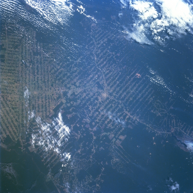
Image Caption: STS079-785-102 Rondonia State, Brazil September 1996
The deforested frontier, located in Rondonia State of west central Brazil, presents a distinctive pattern of clearcut swaths expanding into the Amazon rainforest. The land use pattern that is created by the progressive expansion of agricultural and mining activities is rather unique to Rondonia State. The systematic cutting of the rainforest vegetation usually starts along highways or streams and then side roads are cut through the wilderness at regular interval, thereby creating a very regimented looking landscape of alternating strips of rainforest (dark) and clear cut (lighter) areas. The town of Ariquemes (estimated population of 40000 to 70000 inhabitants) is visible near the center of the picture (small, light colored feature). A short section of highway BR364 is visible as the light-colored, linear feature that extends from north to the southeast through Ariquemes. Another road can also be traced across the landscape, as it heads southwest from Ariquemes. The deforested areas (lighter swaths) reflect the extent to which the land is used for agriculture (ranching and farming) and forestry industries. The cattle industry is a major economic activity in Rondonia at this time.
The deforested frontier, located in Rondonia State of west central Brazil, presents a distinctive pattern of clearcut swaths expanding into the Amazon rainforest. The land use pattern that is created by the progressive expansion of agricultural and mining activities is rather unique to Rondonia State. The systematic cutting of the rainforest vegetation usually starts along highways or streams and then side roads are cut through the wilderness at regular interval, thereby creating a very regimented looking landscape of alternating strips of rainforest (dark) and clear cut (lighter) areas. The town of Ariquemes (estimated population of 40000 to 70000 inhabitants) is visible near the center of the picture (small, light colored feature). A short section of highway BR364 is visible as the light-colored, linear feature that extends from north to the southeast through Ariquemes. Another road can also be traced across the landscape, as it heads southwest from Ariquemes. The deforested areas (lighter swaths) reflect the extent to which the land is used for agriculture (ranching and farming) and forestry industries. The cattle industry is a major economic activity in Rondonia at this time.
