STS079-782-50

| NASA Photo ID | STS079-782-50 |
| Focal Length | 100mm |
| Date taken | 1996.09.17 |
| Time taken | 09:20:00 GMT |
Resolutions offered for this image:
4049 x 4049 pixels 640 x 640 pixels 5700 x 5900 pixels 483 x 500 pixels
4049 x 4049 pixels 640 x 640 pixels 5700 x 5900 pixels 483 x 500 pixels


Cloud masks available for this image:
Spacecraft nadir point: 34.0° N, 31.3° E
Photo center point: 35.0° N, 33.0° E
Photo center point by machine learning:
Photo center point: 35.0° N, 33.0° E
Photo center point by machine learning:
Nadir to Photo Center: Northeast
Spacecraft Altitude: 157 nautical miles (291km)
Country or Geographic Name: | CYPRUS |
Features: | ENTIRE ISLAND, CLOUD EDDY |
| Features Found Using Machine Learning: | |
Cloud Cover Percentage: | 5 (1-10)% |
Sun Elevation Angle: | 58° |
Sun Azimuth: | 166° |
Camera: | Hasselblad |
Focal Length: | 100mm |
Camera Tilt: | 37 degrees |
Format: | 5046: Kodak, natural color positive, Lumiere 100/5046, ASA 100, standard base |
Film Exposure: | Normal |
| Additional Information | |
| Width | Height | Annotated | Cropped | Purpose | Links |
|---|---|---|---|---|---|
| 4049 pixels | 4049 pixels | No | No | Earth From Space collection | Download Image |
| 640 pixels | 640 pixels | No | No | Earth From Space collection | Download Image |
| 5700 pixels | 5900 pixels | No | No | Download Image | |
| 483 pixels | 500 pixels | No | No | Download Image |
Download Packaged File
Download a Google Earth KML for this Image
View photo footprint information
Download a GeoTIFF for this photo
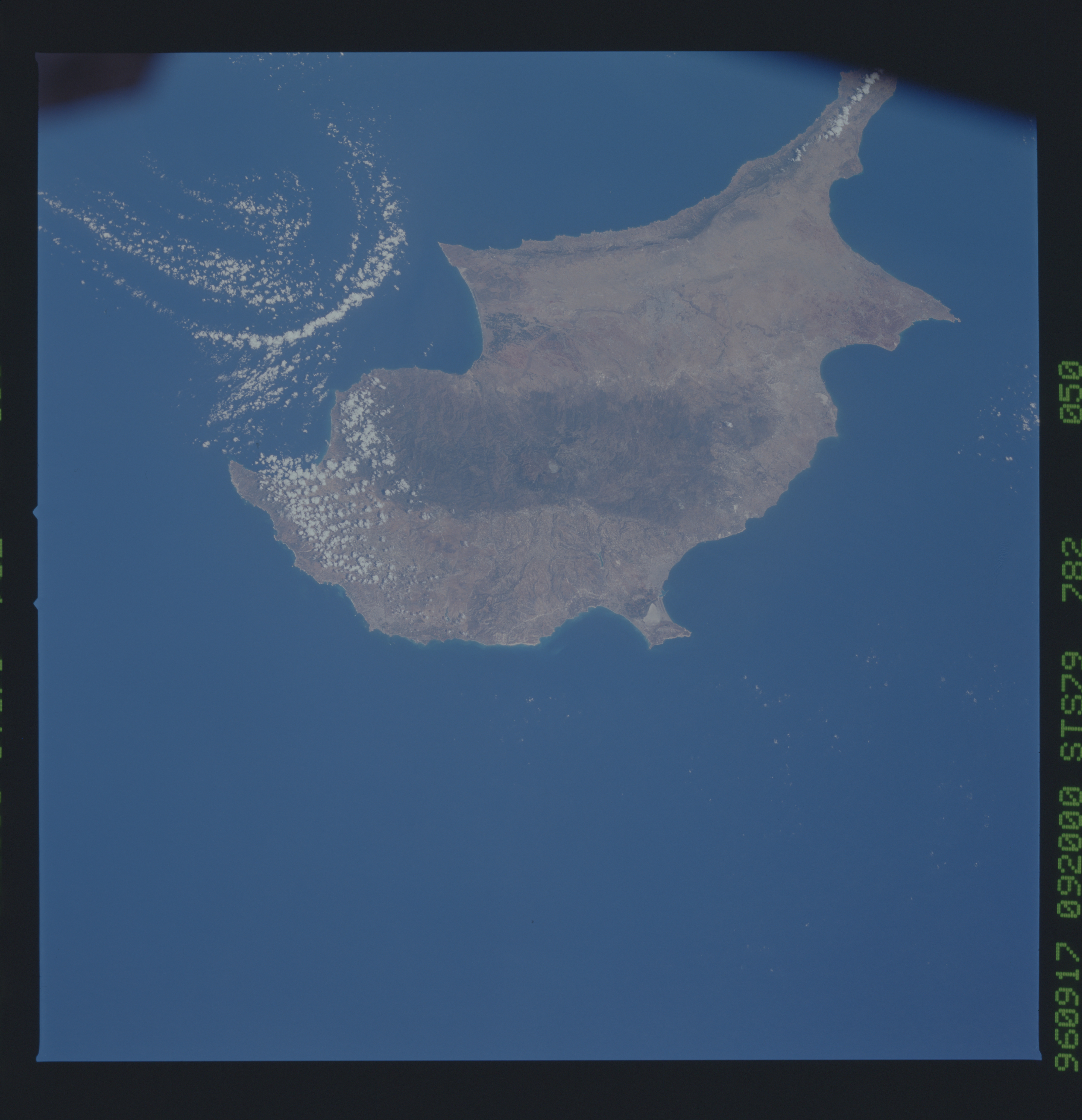
Image Caption: STS079-782-050 The Island of Cyprus September 1996
Covering an area of 3578 sq. miles (9267 sq. km) and located in the eastern Mediterranean Sea, the island of Cyprus can be seen in this northeast-looking view. Cyprus is located 40 miles (60 km) south of Turkey and 60 miles (100 km) west of Syria. There are three main geographic regions on Cyprus. The Troodos Massif, consisting of mostly volcanic rock and some limestone, traverses the southwest portion of the island (darker feature near the center of the image). Iron and copper pyrites are found in the foothills and asbestos and chromium in the higher slopes of the Troodos. The highest elevation in the massif is 6406 feet (1953 meters). Numerous government-owned forests cover the Troodos Massif. On the north coast is the Kyrenia Range, a narrow mountain range reaching elevations of 3000 feet (1000 meters). Consisting mainly of limestone, the range is wooded. Between the two mountain ranges is the Central Plain, where seventy percent of the island's agriculture is located. The capital city of Cyprus, Nicosia, is situated on the Central Plain. The plain consists of a limestone crust and is considered a flat tableland. Heavily forested in ancient times, today the plain is almost treeless.
Covering an area of 3578 sq. miles (9267 sq. km) and located in the eastern Mediterranean Sea, the island of Cyprus can be seen in this northeast-looking view. Cyprus is located 40 miles (60 km) south of Turkey and 60 miles (100 km) west of Syria. There are three main geographic regions on Cyprus. The Troodos Massif, consisting of mostly volcanic rock and some limestone, traverses the southwest portion of the island (darker feature near the center of the image). Iron and copper pyrites are found in the foothills and asbestos and chromium in the higher slopes of the Troodos. The highest elevation in the massif is 6406 feet (1953 meters). Numerous government-owned forests cover the Troodos Massif. On the north coast is the Kyrenia Range, a narrow mountain range reaching elevations of 3000 feet (1000 meters). Consisting mainly of limestone, the range is wooded. Between the two mountain ranges is the Central Plain, where seventy percent of the island's agriculture is located. The capital city of Cyprus, Nicosia, is situated on the Central Plain. The plain consists of a limestone crust and is considered a flat tableland. Heavily forested in ancient times, today the plain is almost treeless.
