STS078-758-46
| NASA Photo ID | STS078-758-46 |
| Focal Length | 250mm |
| Date taken | 1996.06.27 |
| Time taken | 16:17:06 GMT |
Resolutions offered for this image:
4000 x 4000 pixels 639 x 639 pixels 5700 x 5900 pixels 483 x 500 pixels 480 x 478 pixels
4000 x 4000 pixels 639 x 639 pixels 5700 x 5900 pixels 483 x 500 pixels 480 x 478 pixels

Cloud masks available for this image:
Spacecraft nadir point: 34.9° N, 76.5° W
Photo center point: 35.5° N, 76.5° W
Photo center point by machine learning:
Photo center point: 35.5° N, 76.5° W
Photo center point by machine learning:
Nadir to Photo Center: North
Spacecraft Altitude: 144 nautical miles (267km)
Country or Geographic Name: | USA-NORTH CAROLINA |
Features: | PAMLICO RIVER, SEDIMENT |
| Features Found Using Machine Learning: | |
Cloud Cover Percentage: | 10 (1-10)% |
Sun Elevation Angle: | 74° |
Sun Azimuth: | 132° |
Camera: | Hasselblad |
Focal Length: | 250mm |
Camera Tilt: | 14 degrees |
Format: | 2443: Kodak Aerochrome 2443, color IR, thin base, EA-5 process thru June 1999, E-6 process afterward |
Film Exposure: | Normal |
| Additional Information | |
| Width | Height | Annotated | Cropped | Purpose | Links |
|---|---|---|---|---|---|
| 4000 pixels | 4000 pixels | No | No | Earth From Space collection | Download Image |
| 639 pixels | 639 pixels | No | No | Earth From Space collection | Download Image |
| 5700 pixels | 5900 pixels | No | No | Download Image | |
| 483 pixels | 500 pixels | No | No | Download Image | |
| 480 pixels | 478 pixels | Download Image |
Download Packaged File
Download a Google Earth KML for this Image
View photo footprint information
Download a GeoTIFF for this photo
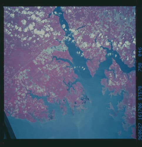
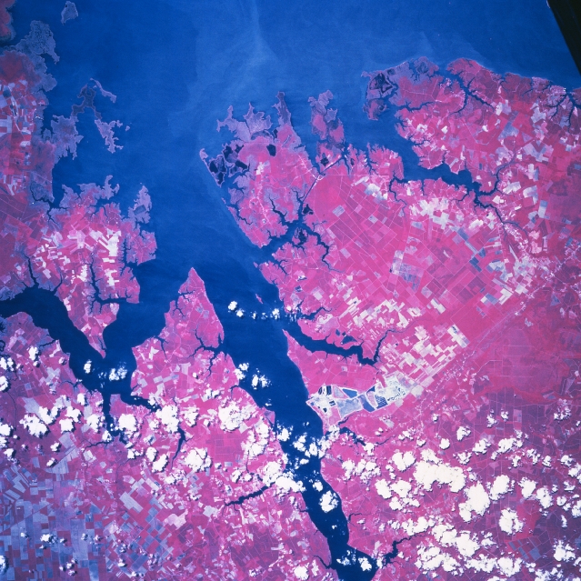
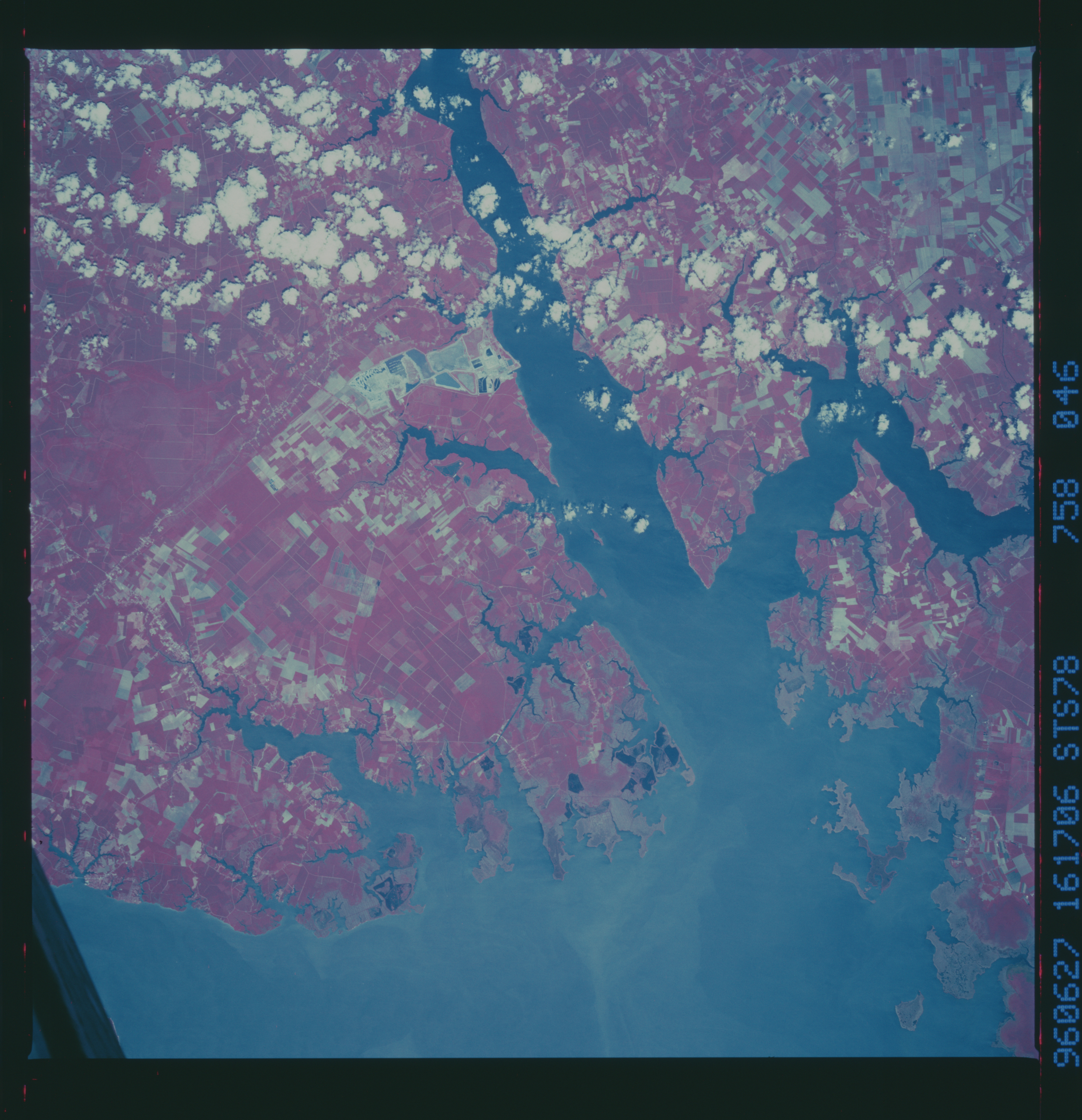
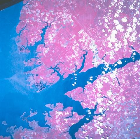
Image Caption: STS078-758-046 Pamlico Sound, North Carolina, USA June 1996
The high quality of this color infrared image of the Pamlico River as it enters the western margin of the Pamlico Sound, graphically shows the usefulness of this type of film to record natural vegetation (green vegetation appears as reddish mauve). Even subtle changes in the reflective pattern within the cultivated fields (mostly angular shaped features) are discernible. The lighter colored areas (non-red colors) show fields that have recently been planted or represent fallowed fields. A series of puffy cumulus clouds, not to be confused with the lighter colored fields, dot the right side of the view. Compare this color infrared image with STS034-83-067, a picture taken with regular color film seven years earlier (1989). While the specific areal coverage for both images is almost identical, the color infrared film makes it easier to discriminate land-water interfaces; swampy, coastal areas; and the individual cultivated field patterns. The expansion of the phosphate mining operation along the south side of the Pamlico River (larger, angular-looking pattern slightly west of center with blue hues) shows significant changes, including features that appear to be spoil banks or mine tailings.
The high quality of this color infrared image of the Pamlico River as it enters the western margin of the Pamlico Sound, graphically shows the usefulness of this type of film to record natural vegetation (green vegetation appears as reddish mauve). Even subtle changes in the reflective pattern within the cultivated fields (mostly angular shaped features) are discernible. The lighter colored areas (non-red colors) show fields that have recently been planted or represent fallowed fields. A series of puffy cumulus clouds, not to be confused with the lighter colored fields, dot the right side of the view. Compare this color infrared image with STS034-83-067, a picture taken with regular color film seven years earlier (1989). While the specific areal coverage for both images is almost identical, the color infrared film makes it easier to discriminate land-water interfaces; swampy, coastal areas; and the individual cultivated field patterns. The expansion of the phosphate mining operation along the south side of the Pamlico River (larger, angular-looking pattern slightly west of center with blue hues) shows significant changes, including features that appear to be spoil banks or mine tailings.
