STS078-751-94
| NASA Photo ID | STS078-751-94 |
| Focal Length | 250mm |
| Date taken | 1996.06.29 |
| Time taken | 17:55:20 GMT |
Resolutions offered for this image:
4096 x 4096 pixels 640 x 640 pixels 5700 x 5900 pixels 483 x 500 pixels 517 x 498 pixels
4096 x 4096 pixels 640 x 640 pixels 5700 x 5900 pixels 483 x 500 pixels 517 x 498 pixels

Cloud masks available for this image:
Spacecraft nadir point: 2.5° S, 55.1° W
Photo center point: 2.0° S, 55.5° W
Photo center point by machine learning:
Photo center point: 2.0° S, 55.5° W
Photo center point by machine learning:
Nadir to Photo Center: Northwest
Spacecraft Altitude: 146 nautical miles (270km)
Country or Geographic Name: | BRAZIL |
Features: | AMAZON RIVER |
| Features Found Using Machine Learning: | |
Cloud Cover Percentage: | 20 (11-25)% |
Sun Elevation Angle: | 49° |
Sun Azimuth: | 311° |
Camera: | Hasselblad |
Focal Length: | 250mm |
Camera Tilt: | 15 degrees |
Format: | 5046: Kodak, natural color positive, Lumiere 100/5046, ASA 100, standard base |
Film Exposure: | Normal |
| Additional Information | |
| Width | Height | Annotated | Cropped | Purpose | Links |
|---|---|---|---|---|---|
| 4096 pixels | 4096 pixels | No | No | Earth From Space collection | Download Image |
| 640 pixels | 640 pixels | No | No | Earth From Space collection | Download Image |
| 5700 pixels | 5900 pixels | No | No | Download Image | |
| 483 pixels | 500 pixels | No | No | Download Image | |
| 517 pixels | 498 pixels | Download Image |
Download Packaged File
Download a Google Earth KML for this Image
View photo footprint information
Download a GeoTIFF for this photo
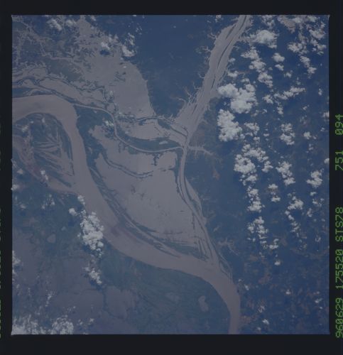
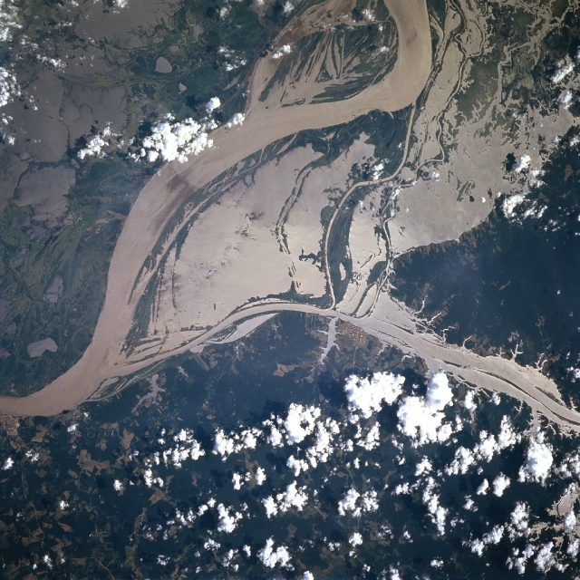
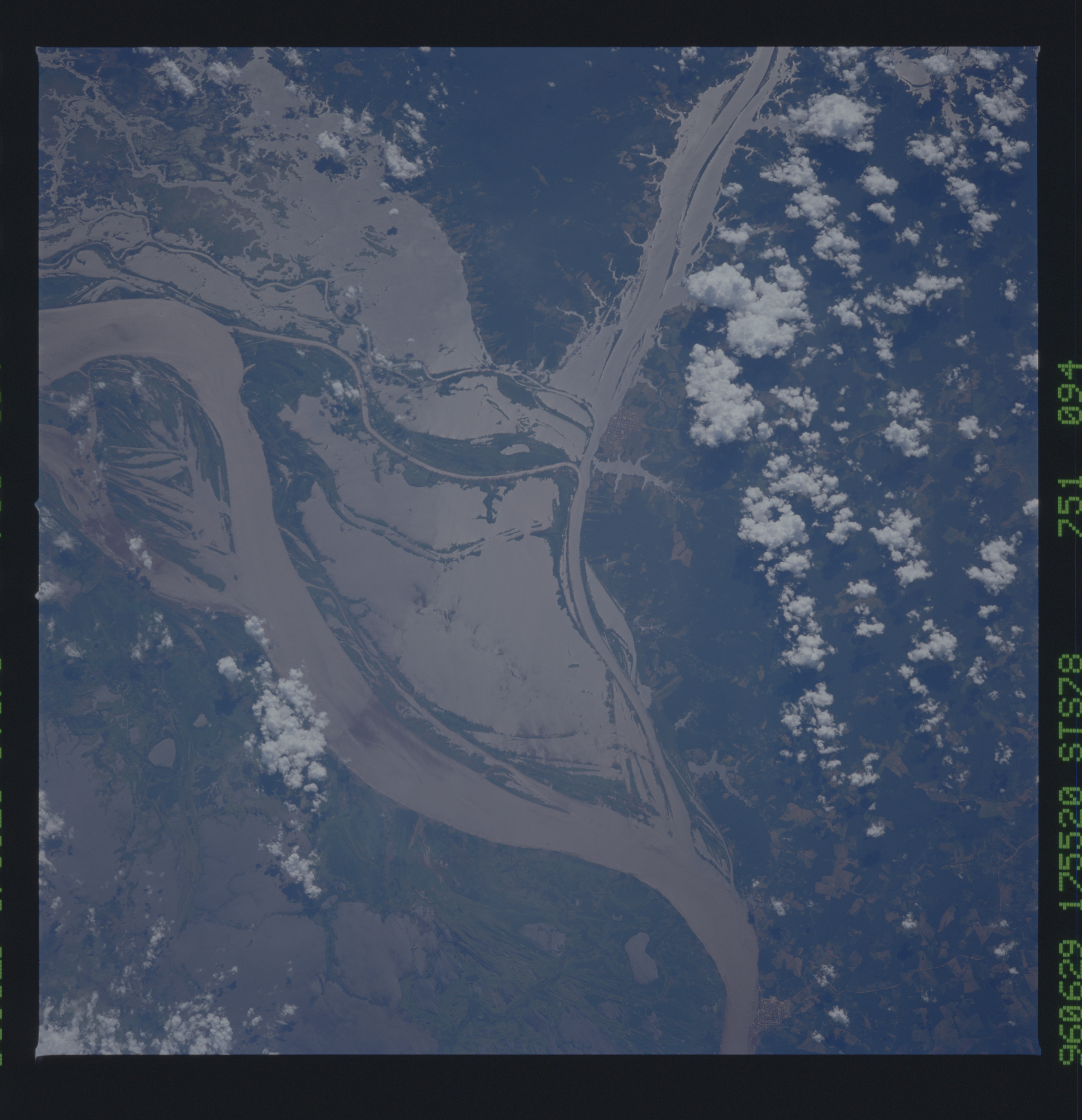
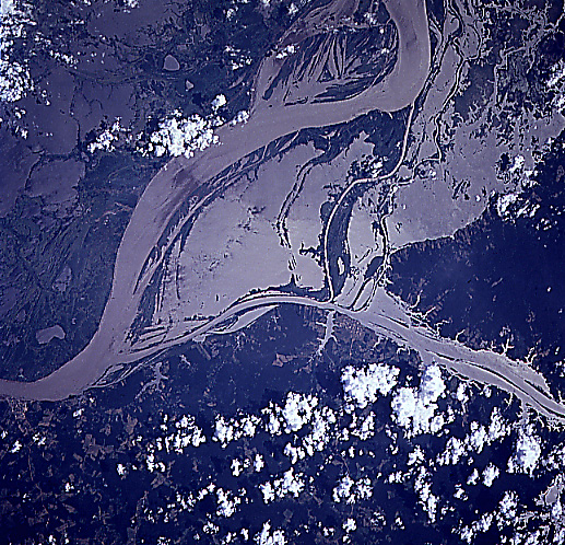
Image Caption: STS078-751-094 Amazon River, Western Para Province, Brazil June 1996
This image shows the flooded condition of a small section of the Amazon River,including the jungle towns of Obidos and Oriximina. The sun's reflection off of the muddy looking river water, called sun glint or sunglitter, helps to identify land-water boundaries in this section of the Amazon River which is roughly midway between Manaus and the Amazon River Delta. By comparing this image to a detailed map of the area it is obvious that the river is flooding in the low lying areas that are adjacent to the floodplain of the main channel of the river. Large areas south of the main channel of the Amazon River are covered by standing water. Patches of cleared land can be identified within the densely vegetated terrain along the northeast side of the Amazon River. The main channel of the Rio Trombetas can be traced southeastward from the right edge of the picture until the river merges with the Amazon just west of the small jungle town of Obidos.
This image shows the flooded condition of a small section of the Amazon River,including the jungle towns of Obidos and Oriximina. The sun's reflection off of the muddy looking river water, called sun glint or sunglitter, helps to identify land-water boundaries in this section of the Amazon River which is roughly midway between Manaus and the Amazon River Delta. By comparing this image to a detailed map of the area it is obvious that the river is flooding in the low lying areas that are adjacent to the floodplain of the main channel of the river. Large areas south of the main channel of the Amazon River are covered by standing water. Patches of cleared land can be identified within the densely vegetated terrain along the northeast side of the Amazon River. The main channel of the Rio Trombetas can be traced southeastward from the right edge of the picture until the river merges with the Amazon just west of the small jungle town of Obidos.
