STS078-747-80
| NASA Photo ID | STS078-747-80 |
| Focal Length | 250mm |
| Date taken | 1996.06.25 |
| Time taken | 08:52:55 GMT |
Resolutions offered for this image:
4078 x 4073 pixels 639 x 639 pixels 5700 x 5900 pixels 483 x 500 pixels
4078 x 4073 pixels 639 x 639 pixels 5700 x 5900 pixels 483 x 500 pixels


Cloud masks available for this image:
Spacecraft nadir point: 37.9° N, 38.3° E
Photo center point: 37.5° N, 38.5° E
Photo center point by machine learning:
Photo center point: 37.5° N, 38.5° E
Photo center point by machine learning:
Nadir to Photo Center: South
Spacecraft Altitude: 145 nautical miles (269km)
Country or Geographic Name: | TURKEY |
Features: | ATATURK RES., SUNGLINT |
| Features Found Using Machine Learning: | |
Cloud Cover Percentage: | 0 (no clouds present) |
Sun Elevation Angle: | 74° |
Sun Azimuth: | 149° |
Camera: | Hasselblad |
Focal Length: | 250mm |
Camera Tilt: | 10 degrees |
Format: | 5046: Kodak, natural color positive, Lumiere 100/5046, ASA 100, standard base |
Film Exposure: | Out of Focus |
| Additional Information | |
| Width | Height | Annotated | Cropped | Purpose | Links |
|---|---|---|---|---|---|
| 4078 pixels | 4073 pixels | No | No | Earth From Space collection | Download Image |
| 639 pixels | 639 pixels | No | No | Earth From Space collection | Download Image |
| 5700 pixels | 5900 pixels | No | No | Download Image | |
| 483 pixels | 500 pixels | No | No | Download Image |
Download Packaged File
Download a Google Earth KML for this Image
View photo footprint information
Download a GeoTIFF for this photo
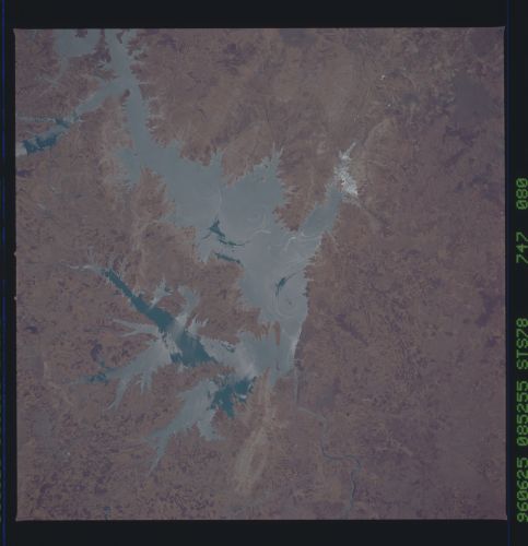
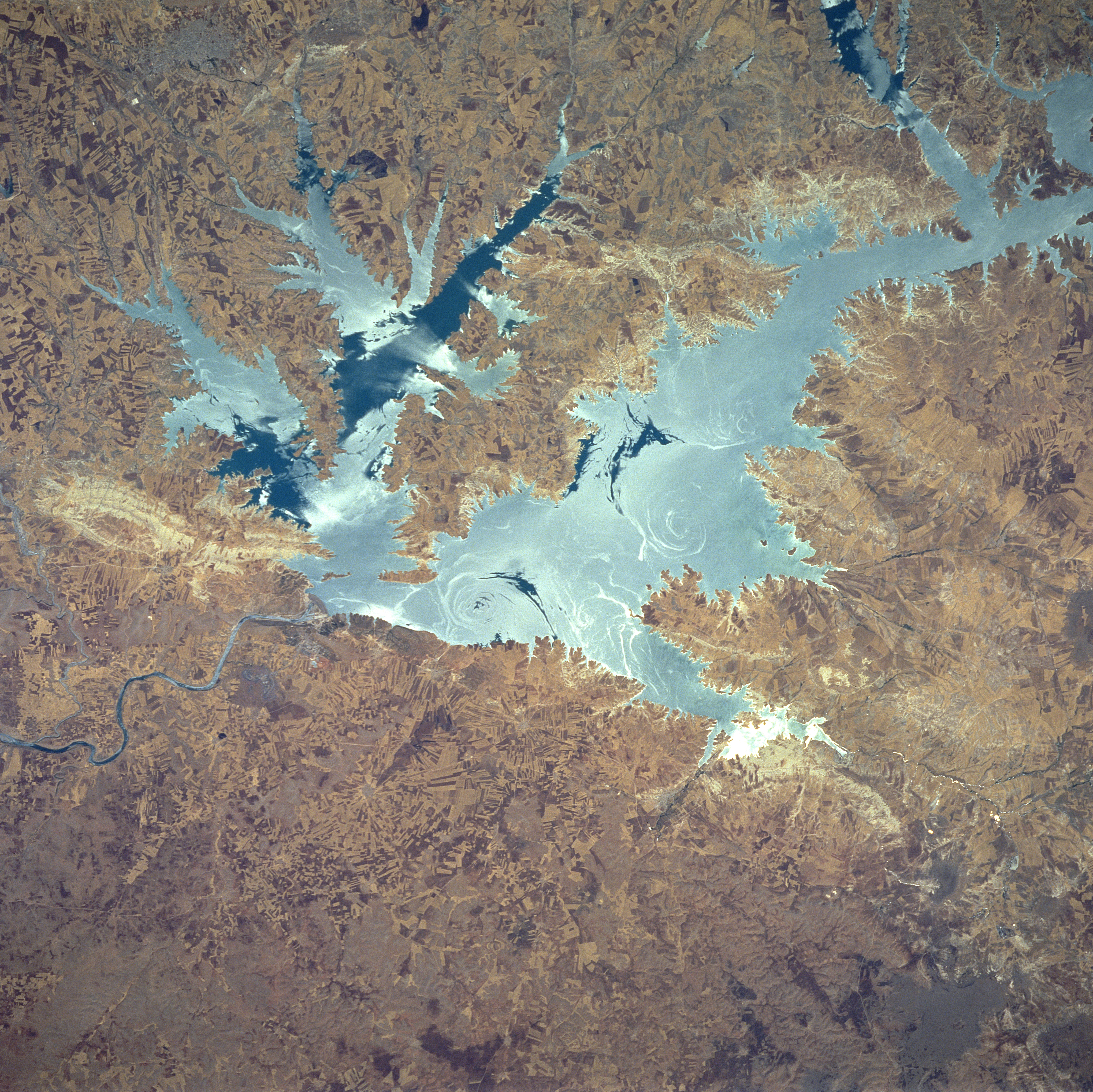
Image Caption: STS078-747-080 Ataturk Reservoir, Turkey June 1996
Presently, the largest man-made lake in Turkey, the Ataturk Reservoir and Dam can be seen in this northeast-looking view. The reservoir, located in south central Turkey on the Euphrates River, was completed in the early 1990's. This dam and other dams further to the north in Turkey on the Euphrates River are causing political and water flow problems between Turkey and its neighbors to the south (Syria and Iraq). Discussions between the three countries to reach an agreeable solution to the problem are ongoing. This particular image was acquired with the waters of the reservoir in sun glint or sun glitter. The sun glint depicts the sun's reflection from the surface of the water. Slicks seen in the water reflect brightly and indicate a smooth water surface. Rough waters give off a diffuse, dull reflection (also reference STS078-747-081). Numerous angular field patterns are visible on the image surrounding the reservoir. The highly reflective surface area immediately to the west of the dam (left center of the image) appears to be an area where rock was extracted for the construction of the dam.
Presently, the largest man-made lake in Turkey, the Ataturk Reservoir and Dam can be seen in this northeast-looking view. The reservoir, located in south central Turkey on the Euphrates River, was completed in the early 1990's. This dam and other dams further to the north in Turkey on the Euphrates River are causing political and water flow problems between Turkey and its neighbors to the south (Syria and Iraq). Discussions between the three countries to reach an agreeable solution to the problem are ongoing. This particular image was acquired with the waters of the reservoir in sun glint or sun glitter. The sun glint depicts the sun's reflection from the surface of the water. Slicks seen in the water reflect brightly and indicate a smooth water surface. Rough waters give off a diffuse, dull reflection (also reference STS078-747-081). Numerous angular field patterns are visible on the image surrounding the reservoir. The highly reflective surface area immediately to the west of the dam (left center of the image) appears to be an area where rock was extracted for the construction of the dam.
