STS078-743-76

| NASA Photo ID | STS078-743-76 |
| Focal Length | 250mm |
| Date taken | 1996.06.25 |
| Time taken | 10:23:57 GMT |
Resolutions offered for this image:
4096 x 4096 pixels 640 x 640 pixels 5700 x 5900 pixels 483 x 500 pixels
4096 x 4096 pixels 640 x 640 pixels 5700 x 5900 pixels 483 x 500 pixels


Cloud masks available for this image:
Spacecraft nadir point: 36.8° N, 21.3° E
Photo center point: 38.0° N, 21.0° E
Photo center point by machine learning:
Photo center point: 38.0° N, 21.0° E
Photo center point by machine learning:
Nadir to Photo Center: North
Spacecraft Altitude: 145 nautical miles (269km)
Country or Geographic Name: | GREECE |
Features: | ZAKINTHOS I., CITY, ROADS |
| Features Found Using Machine Learning: | |
Cloud Cover Percentage: | 5 (1-10)% |
Sun Elevation Angle: | 76° |
Sun Azimuth: | 167° |
Camera: | Hasselblad |
Focal Length: | 250mm |
Camera Tilt: | 27 degrees |
Format: | 5046: Kodak, natural color positive, Lumiere 100/5046, ASA 100, standard base |
Film Exposure: | Normal |
| Additional Information | |
| Width | Height | Annotated | Cropped | Purpose | Links |
|---|---|---|---|---|---|
| 4096 pixels | 4096 pixels | No | No | Earth From Space collection | Download Image |
| 640 pixels | 640 pixels | No | No | Earth From Space collection | Download Image |
| 5700 pixels | 5900 pixels | No | No | Download Image | |
| 483 pixels | 500 pixels | No | No | Download Image |
Download Packaged File
Download a Google Earth KML for this Image
View photo footprint information
Download a GeoTIFF for this photo
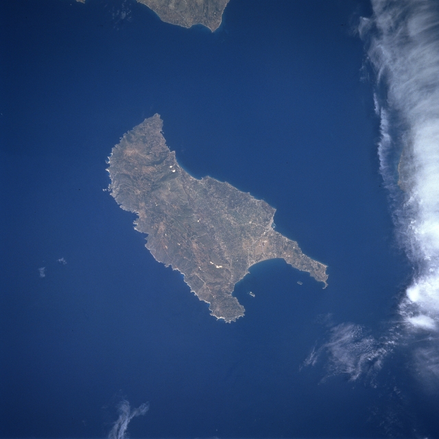
Image Caption: STS078-743-076 Zakinthos Island, Greece June 1996
Located in the Ionian Sea off the west coast of Greece, Zakinthos Island can be seen in this near-nadir view. Zakinthos Island is 25 miles (40 km) long, 12 miles (19 km) wide and covers an area of 157 sq. miles (407 sq. km). The island has a wide fertile plain in its central part with low hills to the west. Wine, currants, citrus fruits, and olive oil are produced on this intensively cultivated island. Zakinthos Island is subject to frequent earthquakes.
Located in the Ionian Sea off the west coast of Greece, Zakinthos Island can be seen in this near-nadir view. Zakinthos Island is 25 miles (40 km) long, 12 miles (19 km) wide and covers an area of 157 sq. miles (407 sq. km). The island has a wide fertile plain in its central part with low hills to the west. Wine, currants, citrus fruits, and olive oil are produced on this intensively cultivated island. Zakinthos Island is subject to frequent earthquakes.
