STS078-737-50
| NASA Photo ID | STS078-737-50 |
| Focal Length | 100mm |
| Date taken | 1996.07.01 |
| Time taken | 06:56:05 GMT |
Resolutions offered for this image:
4049 x 4049 pixels 640 x 640 pixels 5700 x 5900 pixels 483 x 500 pixels
4049 x 4049 pixels 640 x 640 pixels 5700 x 5900 pixels 483 x 500 pixels

Cloud masks available for this image:
Spacecraft nadir point: 38.7° N, 14.9° E
Photo center point: 38.0° N, 15.0° E
Photo center point by machine learning:
Photo center point: 38.0° N, 15.0° E
Photo center point by machine learning:
Nadir to Photo Center: South
Spacecraft Altitude: 140 nautical miles (259km)
Country or Geographic Name: | SICILY |
Features: | MOUNT ETNA, SMOKE, CATANIA |
| Features Found Using Machine Learning: | |
Cloud Cover Percentage: | 0 (no clouds present) |
Sun Elevation Angle: | 36° |
Sun Azimuth: | 87° |
Camera: | Hasselblad |
Focal Length: | 100mm |
Camera Tilt: | 17 degrees |
Format: | 5046: Kodak, natural color positive, Lumiere 100/5046, ASA 100, standard base |
Film Exposure: | Normal |
| Additional Information | |
| Width | Height | Annotated | Cropped | Purpose | Links |
|---|---|---|---|---|---|
| 4049 pixels | 4049 pixels | No | No | Earth From Space collection | Download Image |
| 640 pixels | 640 pixels | No | No | Earth From Space collection | Download Image |
| 5700 pixels | 5900 pixels | No | No | Download Image | |
| 483 pixels | 500 pixels | No | No | Download Image |
Download Packaged File
Download a Google Earth KML for this Image
View photo footprint information
Download a GeoTIFF for this photo
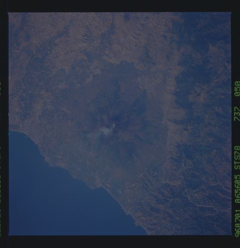
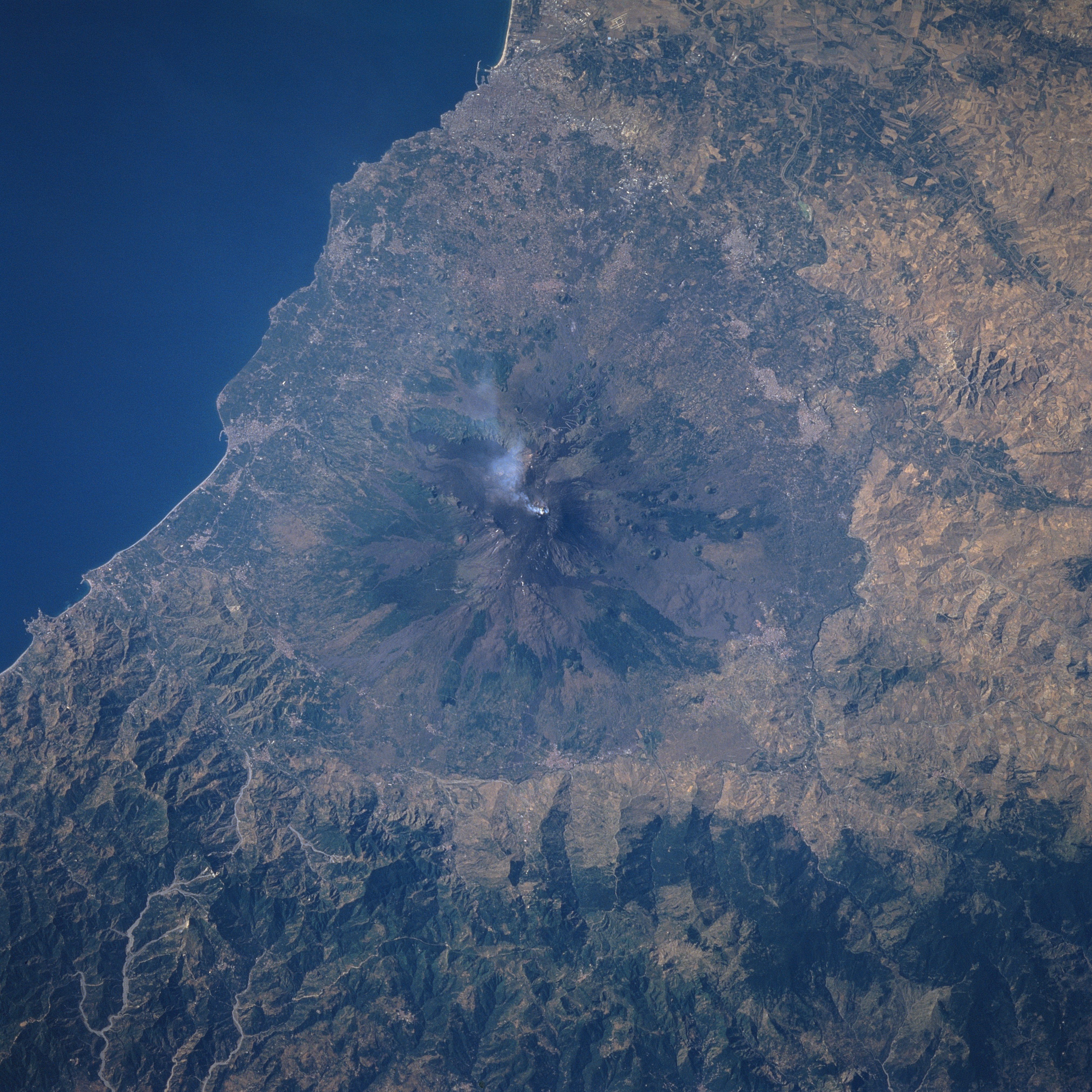
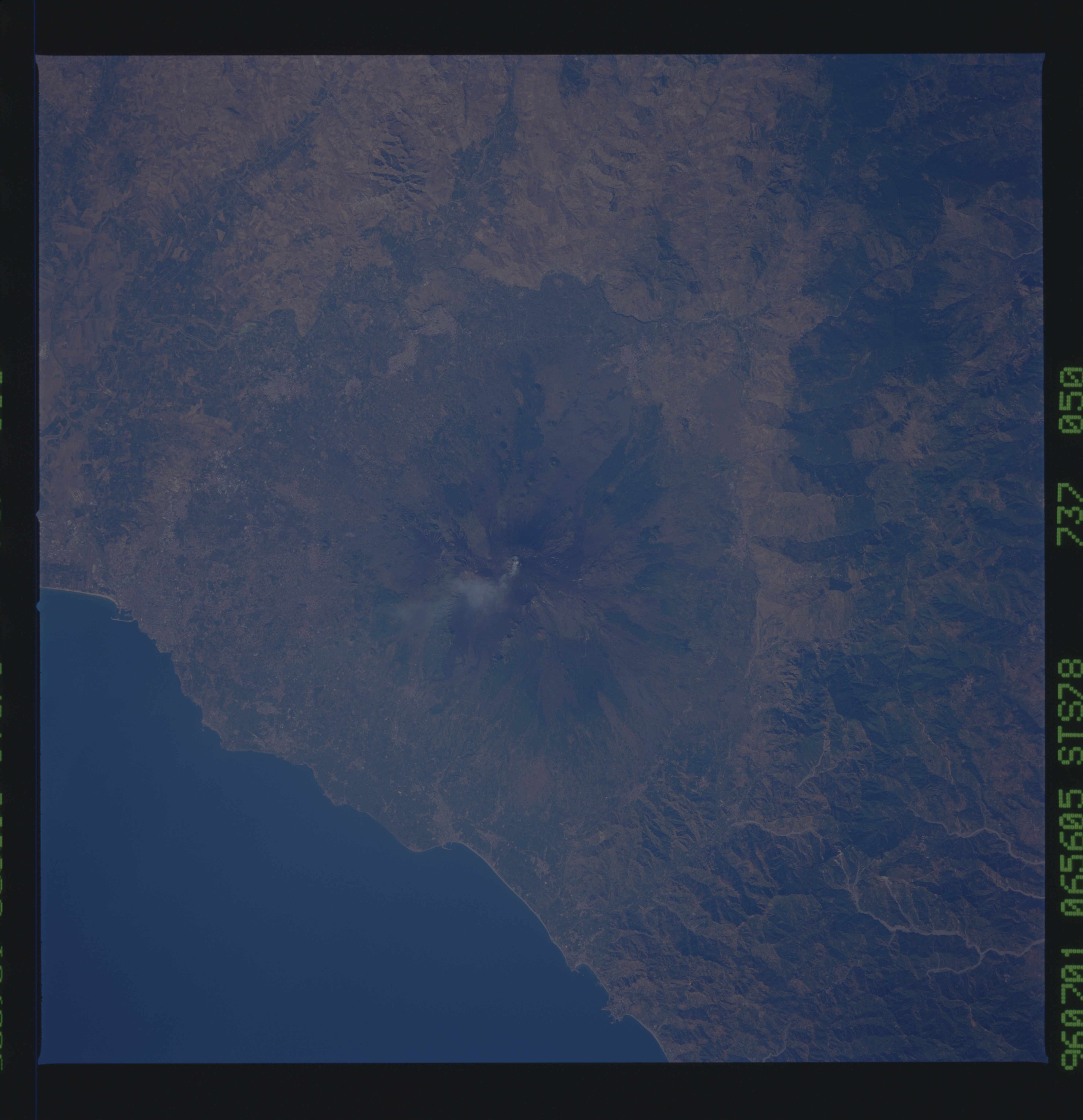
Image Caption: STS078-737-050 Mt. Etna, Sicily, Italy June 1996
Mt. Etna, located in the center of the image, is one of the most active and most studied shield volcanoes in the world. The summit of Mt. Etna is 10991 feet (3350 meters) above sea level. Four small craters are located at the summit. Several cinder cones (generally circular-shaped features) are visible at various locations around the flanks of the volcano. The different colored terrain on the flanks of the volcano indicate lava flows that have occurred at different times and have produced a variety of surface roughness on the slopes of the volcano. One of the reasons that Mt. Etna is closely monitored is to provide advance warning of a major eruption to the surrounding towns and villages that are found around the base of the volcano. Notice that there is a small cloud coming from one of the craters in the summit area at the time this photograph was acquired (STS78-755-039 is a color infrared image of Mt. Etna).
Mt. Etna, located in the center of the image, is one of the most active and most studied shield volcanoes in the world. The summit of Mt. Etna is 10991 feet (3350 meters) above sea level. Four small craters are located at the summit. Several cinder cones (generally circular-shaped features) are visible at various locations around the flanks of the volcano. The different colored terrain on the flanks of the volcano indicate lava flows that have occurred at different times and have produced a variety of surface roughness on the slopes of the volcano. One of the reasons that Mt. Etna is closely monitored is to provide advance warning of a major eruption to the surrounding towns and villages that are found around the base of the volcano. Notice that there is a small cloud coming from one of the craters in the summit area at the time this photograph was acquired (STS78-755-039 is a color infrared image of Mt. Etna).
