STS078-734-23
| NASA Photo ID | STS078-734-23 |
| Focal Length | 250mm |
| Date taken | 1996.06.25 |
| Time taken | 14:45:40 GMT |
Resolutions offered for this image:
3060 x 3060 pixels 1200 x 1200 pixels 4054 x 4054 pixels 640 x 640 pixels 5700 x 5900 pixels 483 x 500 pixels 4200 x 4244 pixels 648 x 675 pixels 479 x 479 pixels 760 x 768 pixels
3060 x 3060 pixels 1200 x 1200 pixels 4054 x 4054 pixels 640 x 640 pixels 5700 x 5900 pixels 483 x 500 pixels 4200 x 4244 pixels 648 x 675 pixels 479 x 479 pixels 760 x 768 pixels


Cloud masks available for this image:
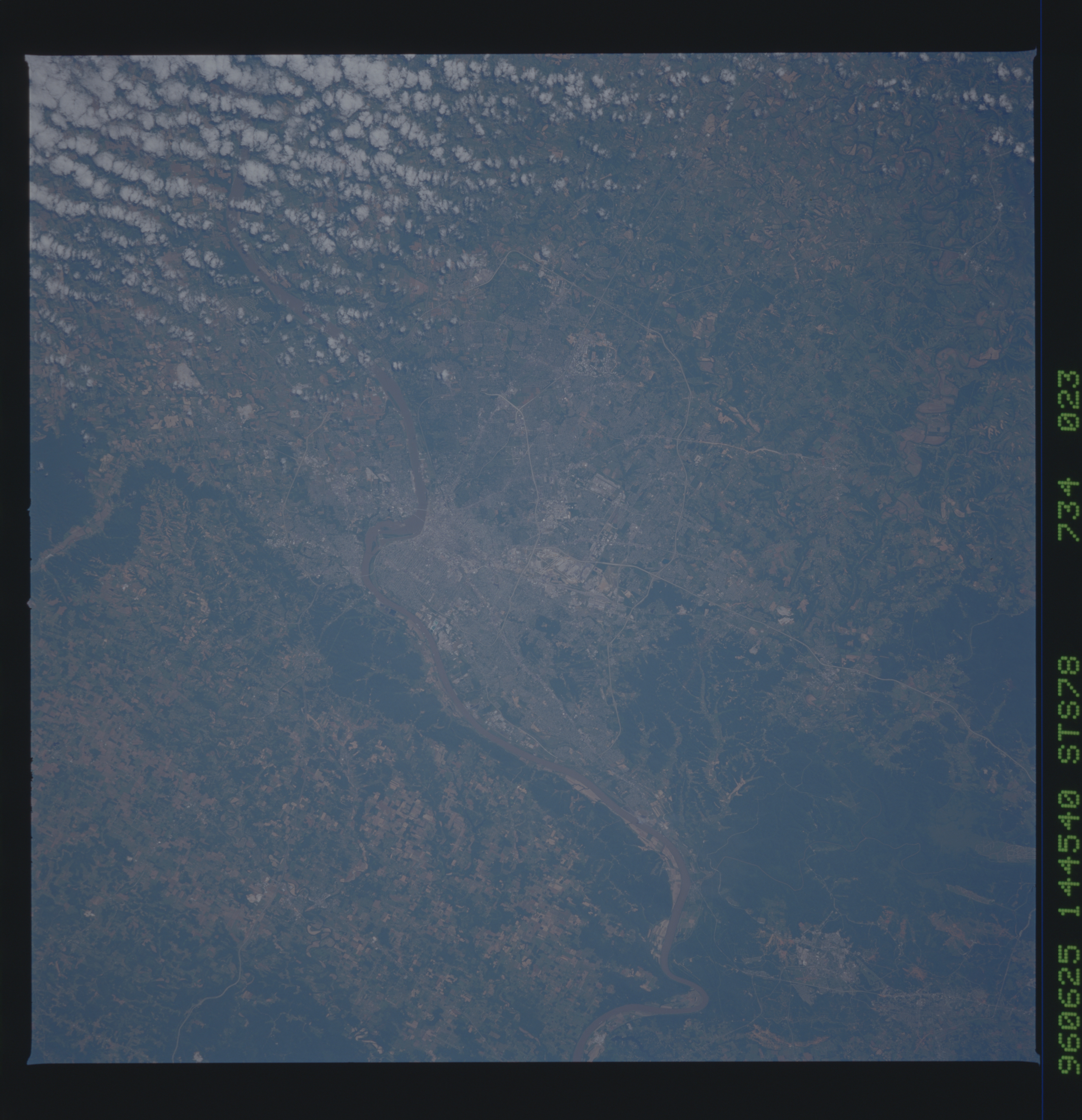
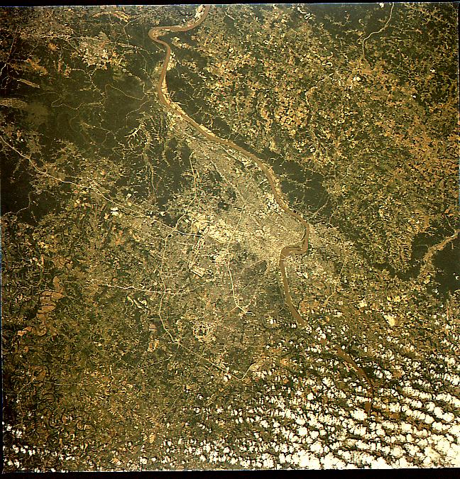
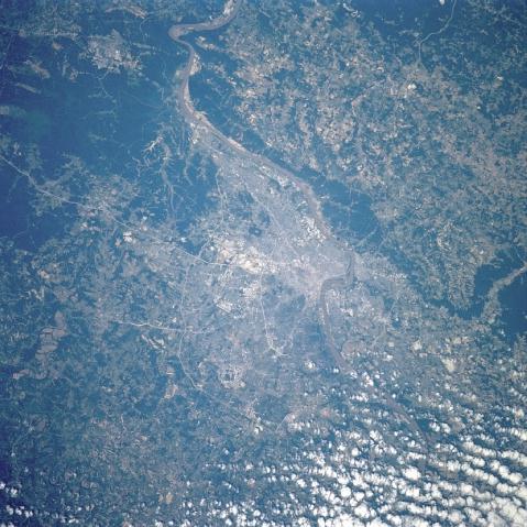
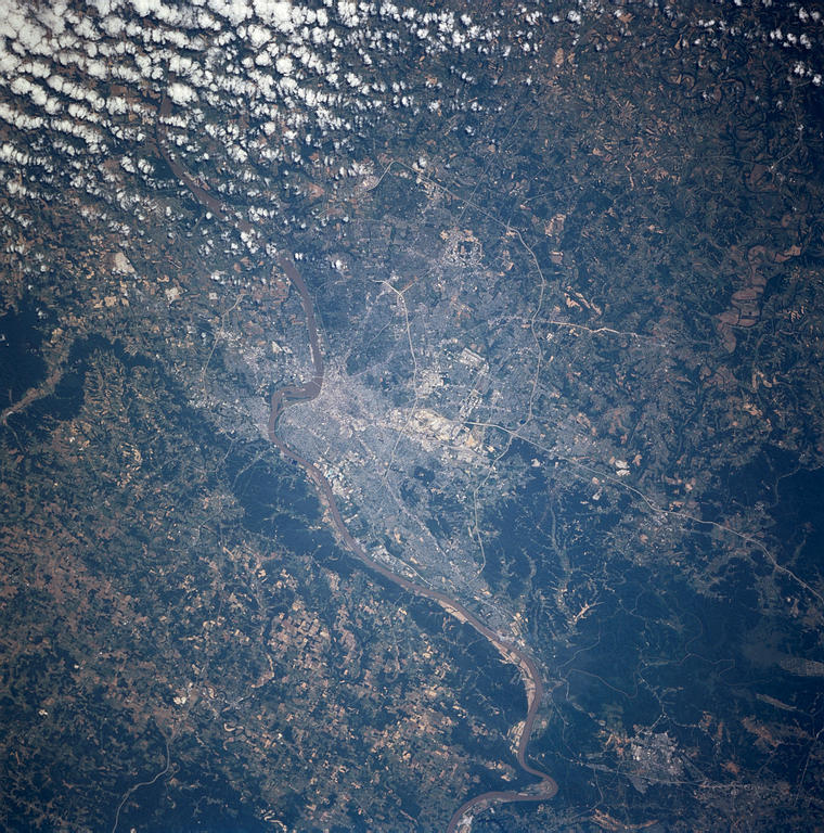
Spacecraft nadir point: 38.2° N, 84.1° W
Photo center point: 38.0° N, 86.0° W
Photo center point by machine learning:
Photo center point: 38.0° N, 86.0° W
Photo center point by machine learning:
Nadir to Photo Center: West
Spacecraft Altitude: 144 nautical miles (267km)
Country or Geographic Name: | USA-KENTUCKY |
Features: | NEW ALBANY, LOUISVILLE |
| Features Found Using Machine Learning: | |
Cloud Cover Percentage: | 10 (1-10)% |
Sun Elevation Angle: | 50° |
Sun Azimuth: | 99° |
Camera: | Hasselblad |
Focal Length: | 250mm |
Camera Tilt: | 39 degrees |
Format: | 5046: Kodak, natural color positive, Lumiere 100/5046, ASA 100, standard base |
Film Exposure: | Normal |
| Additional Information | |
| Width | Height | Annotated | Cropped | Purpose | Links |
|---|---|---|---|---|---|
| 3060 pixels | 3060 pixels | No | No | Cities collection | Download Image |
| 1200 pixels | 1200 pixels | No | No | Cities collection | Download Image |
| 4054 pixels | 4054 pixels | No | No | Earth From Space collection | Download Image |
| 640 pixels | 640 pixels | No | No | Earth From Space collection | Download Image |
| 5700 pixels | 5900 pixels | No | No | Download Image | |
| 483 pixels | 500 pixels | No | No | Download Image | |
| 4200 pixels | 4244 pixels | No | Yes | Download Image | |
| 648 pixels | 675 pixels | No | No | Download Image | |
| 479 pixels | 479 pixels | Download Image | |||
| 760 pixels | 768 pixels | No | Yes | Download Image |
Download Packaged File
Download a Google Earth KML for this Image
View photo footprint information
Download a GeoTIFF for this photo
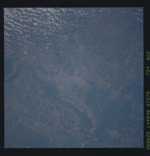
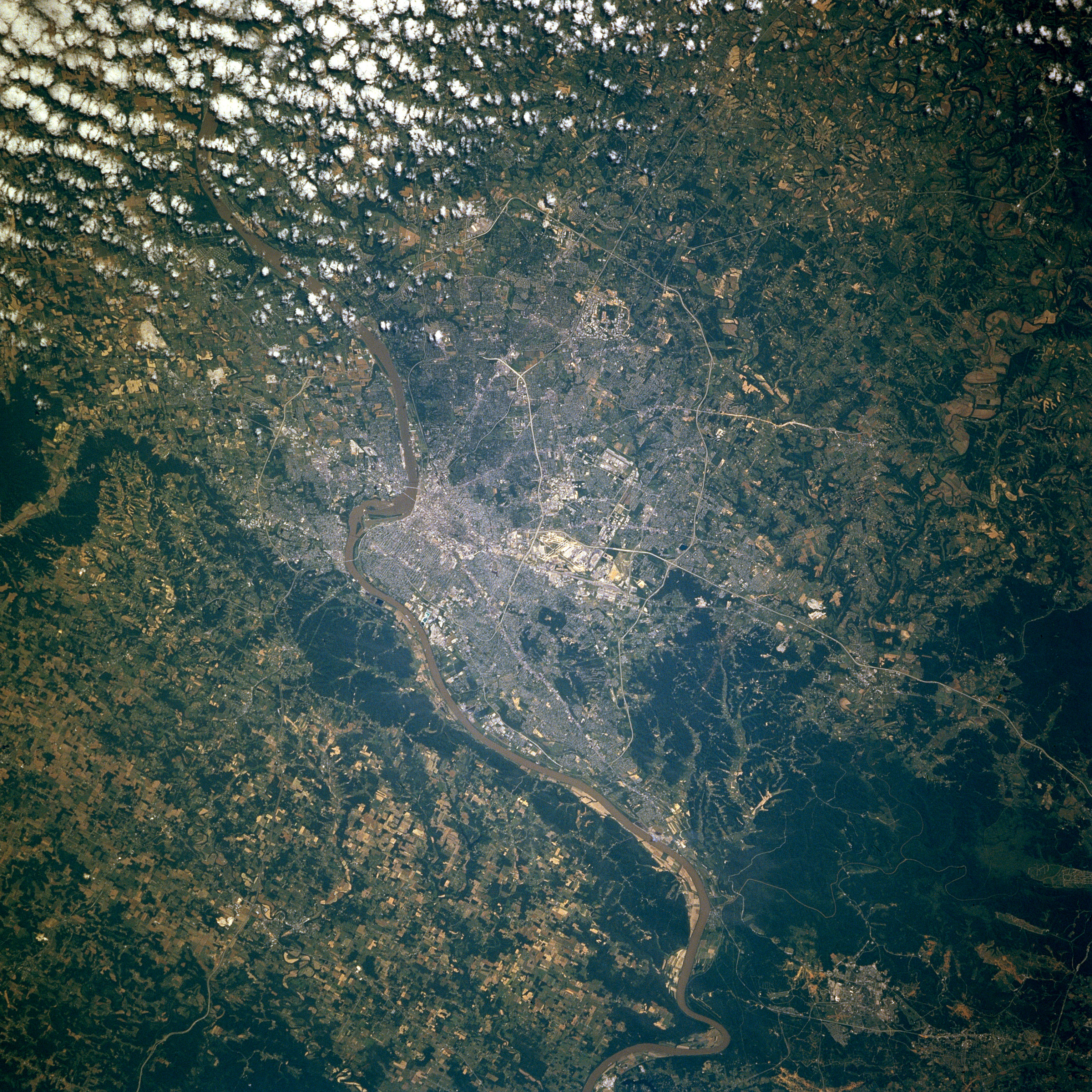
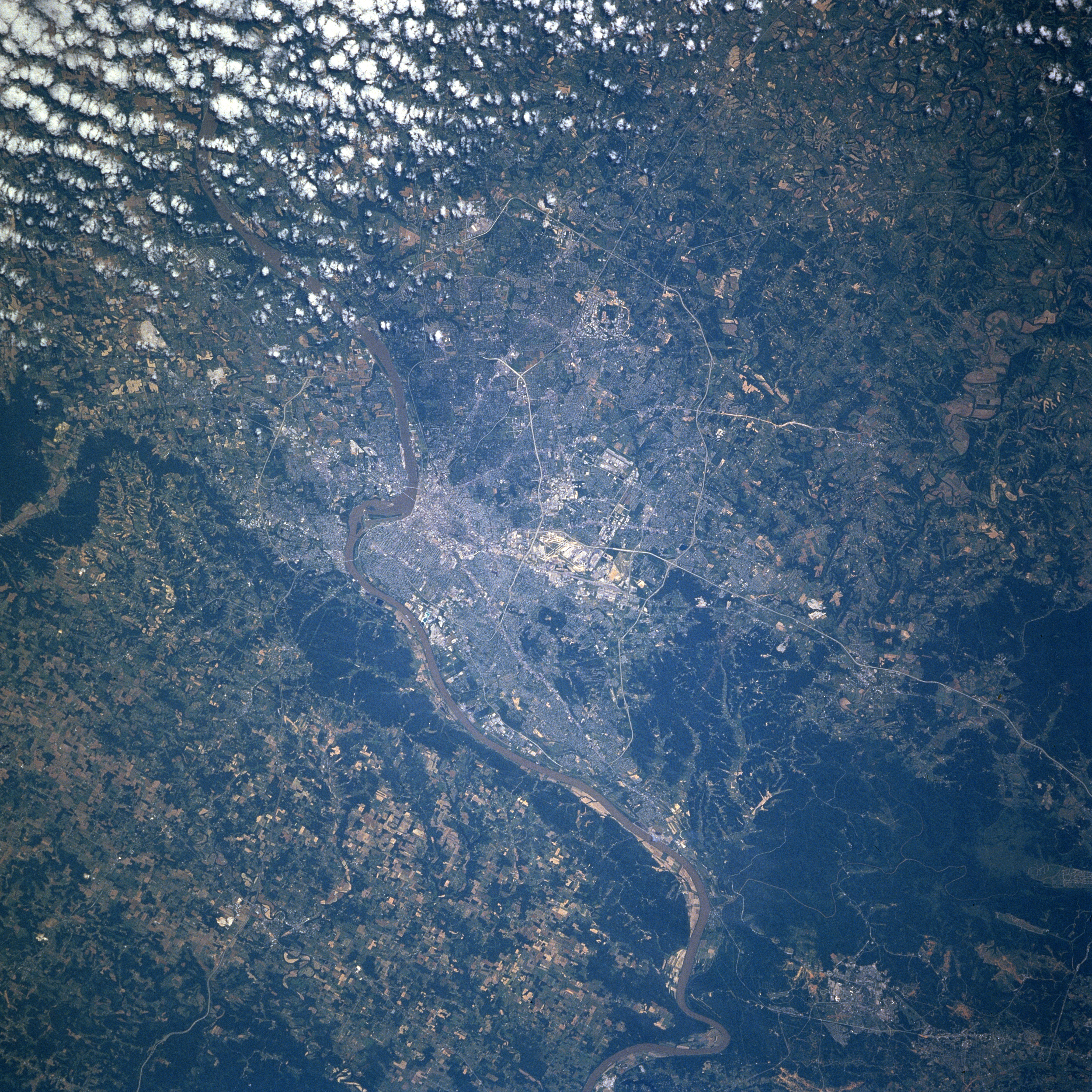
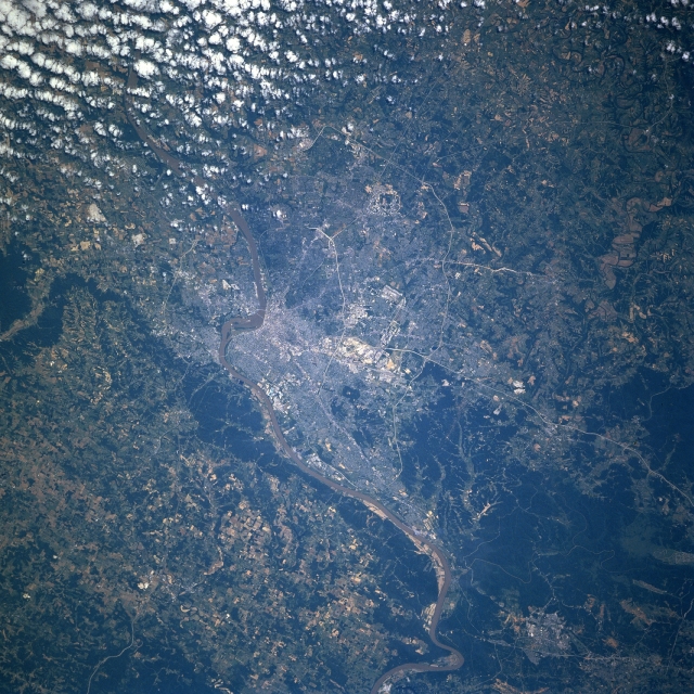
Image Caption: STS078-734-023 Louisville, Kentucky, USA June 1996 Several bridges span the Ohio River, the narrow muddy-looking feature that extends across the image from northeast to southwest. Downtown Louisville is adjacent to the Ohio River just east of the rounded promontory that juts northward into the Ohio River (slightly right of center). Indiana is north of the river and Kentucky is south of the river. Major highways can be traced across the Louisville region. These roads include an inner loop or beltway (Interstate Highway 264) and an outer loop (Interstate Highway 265). Additionally, Interstate Highway 65, a major north-south artery, is especially easy to discern as it enters the south side of the city. A cluster of highly reflective features (center of the picture) shows the location of Standiford Field and a large federal installation. The darker landscape maps the extent of heavily wooded, rugged, undeveloped terrain, located southwest of the urban area. There is also a narrow band of wooded acreage along the north bank of the Ohio River west of Louisville.
