STS078-733-30
| NASA Photo ID | STS078-733-30 |
| Focal Length | 40mm |
| Date taken | 1996.__.__ |
| Time taken | GMT |
Resolutions offered for this image:
4049 x 4049 pixels 640 x 640 pixels 5700 x 5900 pixels 483 x 500 pixels
4049 x 4049 pixels 640 x 640 pixels 5700 x 5900 pixels 483 x 500 pixels


Cloud masks available for this image:
Spacecraft nadir point:
Photo center point: 16.0° S, 69.5° W
Photo center point by machine learning:
Photo center point: 16.0° S, 69.5° W
Photo center point by machine learning:
Nadir to Photo Center:
Spacecraft Altitude: nautical miles (0km)
Country or Geographic Name: | PERU |
Features: | LAKE TITICACA, DRAINAGE |
| Features Found Using Machine Learning: | |
Cloud Cover Percentage: | 20 (11-25)% |
Sun Elevation Angle: | ° |
Sun Azimuth: | ° |
Camera: | Hasselblad |
Focal Length: | 40mm |
Camera Tilt: | Low Oblique |
Format: | 5046: Kodak, natural color positive, Lumiere 100/5046, ASA 100, standard base |
Film Exposure: | Normal |
| Additional Information | |
| Width | Height | Annotated | Cropped | Purpose | Links |
|---|---|---|---|---|---|
| 4049 pixels | 4049 pixels | No | No | Earth From Space collection | Download Image |
| 640 pixels | 640 pixels | No | No | Earth From Space collection | Download Image |
| 5700 pixels | 5900 pixels | No | No | Download Image | |
| 483 pixels | 500 pixels | No | No | Download Image |
Download Packaged File
Download a Google Earth KML for this Image
View photo footprint information
Download a GeoTIFF for this photo
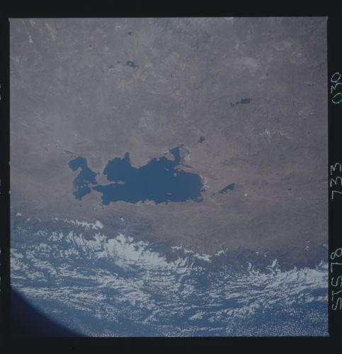
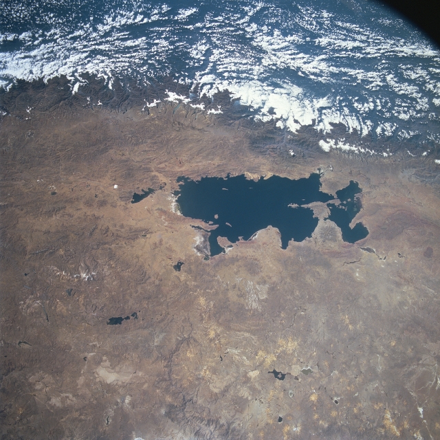
Image Caption: STS078-733-030 Lake Titicaca, Peru and Bolivia June 1996
Located in the high plateau of the Andes Mountains at roughly 12500 feet (3700 meters) above sea level, between Peru and Bolivia is Lake Titicaca (large dark feature at center). The lake is divided by a north-south boundary that partitions the northwest section of the lake to Peru and the southeast section to Bolivia. Climatically, this section of the Altiplano is classified as semi-desert. Most of the precipitation that falls comes with the summer rains. This moisture, or recharge of freshwater into Lake Titicaca, is supplemented by melting snow and ice from the Andes Mountains. This image graphically shows the impact that the Andes Mountains has on the local climate (cloud covered eastern slopes of the Andes versus cloud free conditions on the Altiplano).
Located in the high plateau of the Andes Mountains at roughly 12500 feet (3700 meters) above sea level, between Peru and Bolivia is Lake Titicaca (large dark feature at center). The lake is divided by a north-south boundary that partitions the northwest section of the lake to Peru and the southeast section to Bolivia. Climatically, this section of the Altiplano is classified as semi-desert. Most of the precipitation that falls comes with the summer rains. This moisture, or recharge of freshwater into Lake Titicaca, is supplemented by melting snow and ice from the Andes Mountains. This image graphically shows the impact that the Andes Mountains has on the local climate (cloud covered eastern slopes of the Andes versus cloud free conditions on the Altiplano).
