STS078-732-9
| NASA Photo ID | STS078-732-9 |
| Focal Length | 250mm |
| Date taken | 1996.06.24 |
| Time taken | 10:22:02 GMT |
Resolutions offered for this image:
4096 x 4096 pixels 640 x 640 pixels 5700 x 5900 pixels 483 x 500 pixels
4096 x 4096 pixels 640 x 640 pixels 5700 x 5900 pixels 483 x 500 pixels


Cloud masks available for this image:
Spacecraft nadir point: 39.1° N, 1.4° E
Photo center point: 40.5° N, 0.5° E
Photo center point by machine learning:
Photo center point: 40.5° N, 0.5° E
Photo center point by machine learning:
Nadir to Photo Center: Northwest
Spacecraft Altitude: 145 nautical miles (269km)
Country or Geographic Name: | SPAIN |
Features: | RIO EBRO DELTA, AGR., COAST |
| Features Found Using Machine Learning: | |
Cloud Cover Percentage: | 5 (1-10)% |
Sun Elevation Angle: | 65° |
Sun Azimuth: | 121° |
Camera: | Hasselblad |
Focal Length: | 250mm |
Camera Tilt: | 35 degrees |
Format: | 5046: Kodak, natural color positive, Lumiere 100/5046, ASA 100, standard base |
Film Exposure: | Normal |
| Additional Information | |
| Width | Height | Annotated | Cropped | Purpose | Links |
|---|---|---|---|---|---|
| 4096 pixels | 4096 pixels | No | No | Earth From Space collection | Download Image |
| 640 pixels | 640 pixels | No | No | Earth From Space collection | Download Image |
| 5700 pixels | 5900 pixels | No | No | Download Image | |
| 483 pixels | 500 pixels | No | No | Download Image |
Download Packaged File
Download a Google Earth KML for this Image
View photo footprint information
Download a GeoTIFF for this photo
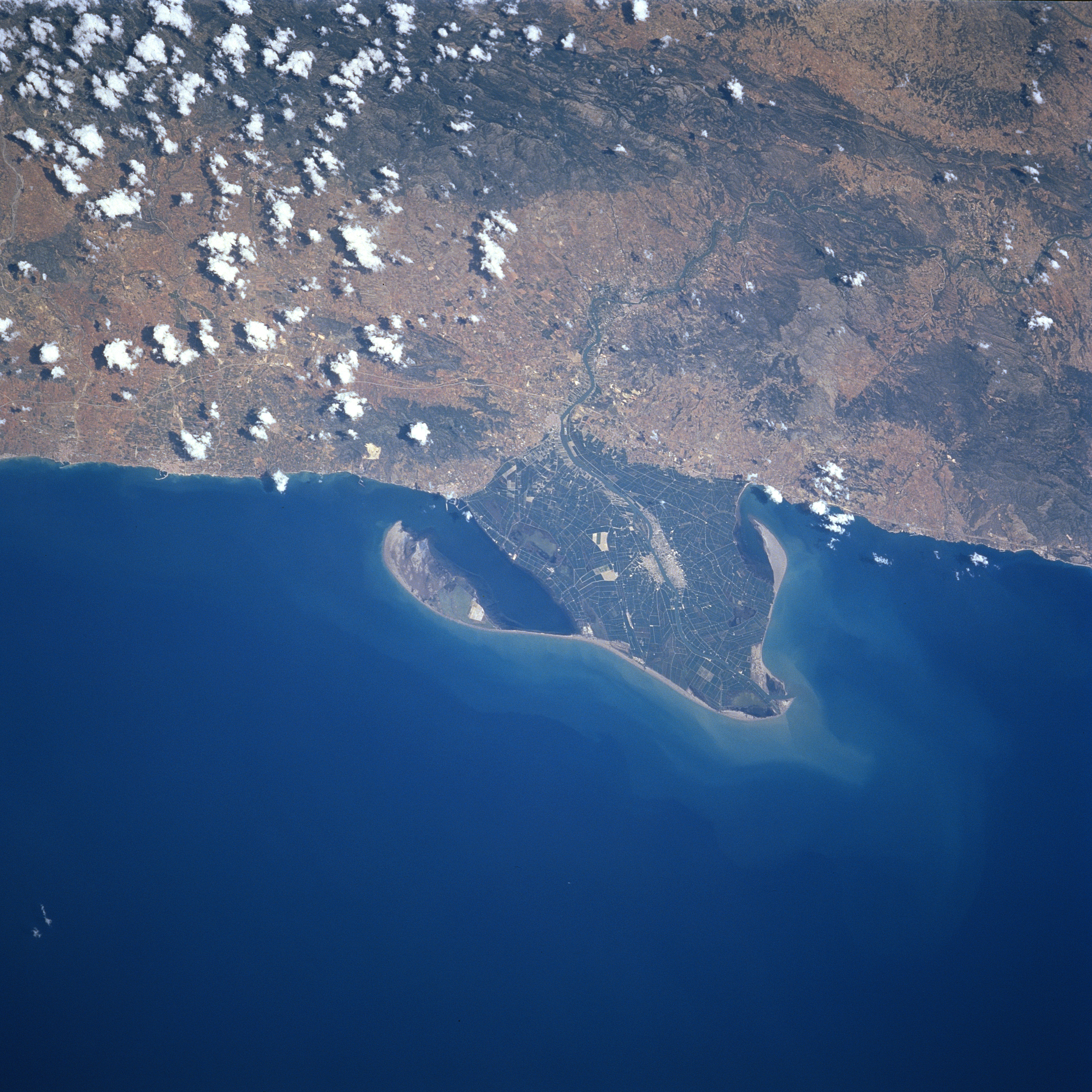
Image Caption: STS078-732-009 Ebro River Delta, Spain June 1996
The deposition of sediment from the Ebro River has created a unique-looking, triangular-shaped delta along the east coast of Spain. The delta is a recently created landform, dating back only a few centuries. The growth of the delta during the 1900's, however, has been dramatically reduced by the construction of dams upstream on the Ebro River and several tributaries. The dams have reduced the flow of water through the delta and the water that does pass through the delta contains less silt. There is evidence (lighter colored water in the coastal waters at the mouth of the river) in the image that sediment continues to pass through the extensive plains of the delta. Numerous canals and ponds interconnect various parts of the delta. A variety of fruits and vegetables are grown in the region with rice farming occupying a large area of the agricultural land. The mountain range (darker areas inland, somewhat obscured by clouds) that parallels the coast is part of the young Catalonian coastal mountains.
The deposition of sediment from the Ebro River has created a unique-looking, triangular-shaped delta along the east coast of Spain. The delta is a recently created landform, dating back only a few centuries. The growth of the delta during the 1900's, however, has been dramatically reduced by the construction of dams upstream on the Ebro River and several tributaries. The dams have reduced the flow of water through the delta and the water that does pass through the delta contains less silt. There is evidence (lighter colored water in the coastal waters at the mouth of the river) in the image that sediment continues to pass through the extensive plains of the delta. Numerous canals and ponds interconnect various parts of the delta. A variety of fruits and vegetables are grown in the region with rice farming occupying a large area of the agricultural land. The mountain range (darker areas inland, somewhat obscured by clouds) that parallels the coast is part of the young Catalonian coastal mountains.
