STS078-732-82

| NASA Photo ID | STS078-732-82 |
| Focal Length | 250mm |
| Date taken | 1996.06.24 |
| Time taken | 10:31:16 GMT |
Resolutions offered for this image:
4084 x 4054 pixels 639 x 635 pixels 5700 x 5900 pixels 483 x 500 pixels 524 x 513 pixels
4084 x 4054 pixels 639 x 635 pixels 5700 x 5900 pixels 483 x 500 pixels 524 x 513 pixels


Cloud masks available for this image:
Spacecraft nadir point: 31.9° N, 44.0° E
Photo center point: 32.5° N, 43.5° E
Photo center point by machine learning:
Photo center point: 32.5° N, 43.5° E
Photo center point by machine learning:
Nadir to Photo Center: Northwest
Spacecraft Altitude: 146 nautical miles (270km)
Country or Geographic Name: | IRAQ |
Features: | LAKE RAZAZAH, DESERT |
| Features Found Using Machine Learning: | |
Cloud Cover Percentage: | 0 (no clouds present) |
Sun Elevation Angle: | 70° |
Sun Azimuth: | 251° |
Camera: | Hasselblad |
Focal Length: | 250mm |
Camera Tilt: | 18 degrees |
Format: | 5046: Kodak, natural color positive, Lumiere 100/5046, ASA 100, standard base |
Film Exposure: | Normal |
| Additional Information | |
| Width | Height | Annotated | Cropped | Purpose | Links |
|---|---|---|---|---|---|
| 4084 pixels | 4054 pixels | No | No | Earth From Space collection | Download Image |
| 639 pixels | 635 pixels | No | No | Earth From Space collection | Download Image |
| 5700 pixels | 5900 pixels | No | No | Download Image | |
| 483 pixels | 500 pixels | No | No | Download Image | |
| 524 pixels | 513 pixels | No | No | Download Image |
Download Packaged File
Download a Google Earth KML for this Image
View photo footprint information
Download a GeoTIFF for this photo
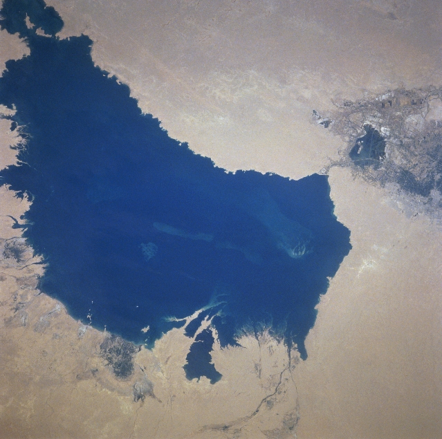
Image Caption: STS078-732-082 Lake Milh, Iraq June 1996
Lake Milh, also known as the Sea of Salt, can be seen in this northeast-looking view. Located west-southwest of Baghdad, Lake Milh is a depression in which excess water from the Euphrates River, is diverted by a controlled escape channel or canal. The lake is rather shallow and water levels change with the seasons. Due to the salts and the changing water levels, few recreational areas exist around the lake.
Lake Milh, also known as the Sea of Salt, can be seen in this northeast-looking view. Located west-southwest of Baghdad, Lake Milh is a depression in which excess water from the Euphrates River, is diverted by a controlled escape channel or canal. The lake is rather shallow and water levels change with the seasons. Due to the salts and the changing water levels, few recreational areas exist around the lake.
