STS075-723-21
| NASA Photo ID | STS075-723-21 |
| Focal Length | 250mm |
| Date taken | 1996.__.__ |
| Time taken | GMT |
Resolutions offered for this image:
3927 x 3872 pixels 640 x 631 pixels 5700 x 5900 pixels 500 x 518 pixels 640 x 480 pixels
3927 x 3872 pixels 640 x 631 pixels 5700 x 5900 pixels 500 x 518 pixels 640 x 480 pixels

Cloud masks available for this image:
Spacecraft nadir point:
Photo center point: 29.5° N, 94.5° W
Photo center point by machine learning:
Photo center point: 29.5° N, 94.5° W
Photo center point by machine learning:
Nadir to Photo Center: Northwest
Spacecraft Altitude: nautical miles (0km)
Country or Geographic Name: | USA-TEXAS |
Features: | GALVESTON & TRINTY BAY |
| Features Found Using Machine Learning: | |
Cloud Cover Percentage: | 0 (no clouds present) |
Sun Elevation Angle: | ° |
Sun Azimuth: | ° |
Camera: | Hasselblad |
Focal Length: | 250mm |
Camera Tilt: | Low Oblique |
Format: | 5046: Kodak, natural color positive, Lumiere 100/5046, ASA 100, standard base |
Film Exposure: | Normal |
| Additional Information | |
| Width | Height | Annotated | Cropped | Purpose | Links |
|---|---|---|---|---|---|
| 3927 pixels | 3872 pixels | No | No | Earth From Space collection | Download Image |
| 640 pixels | 631 pixels | No | No | Earth From Space collection | Download Image |
| 5700 pixels | 5900 pixels | No | No | Download Image | |
| 500 pixels | 518 pixels | No | No | Download Image | |
| 640 pixels | 480 pixels | No | No | Download Image |
Download Packaged File
Download a Google Earth KML for this Image
View photo footprint information
Download a GeoTIFF for this photo
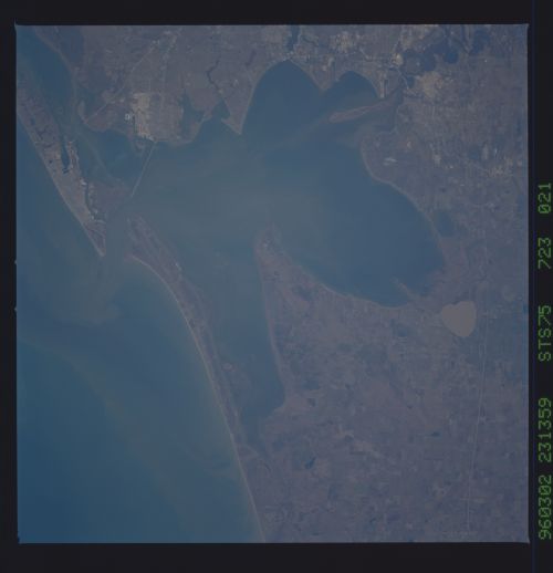
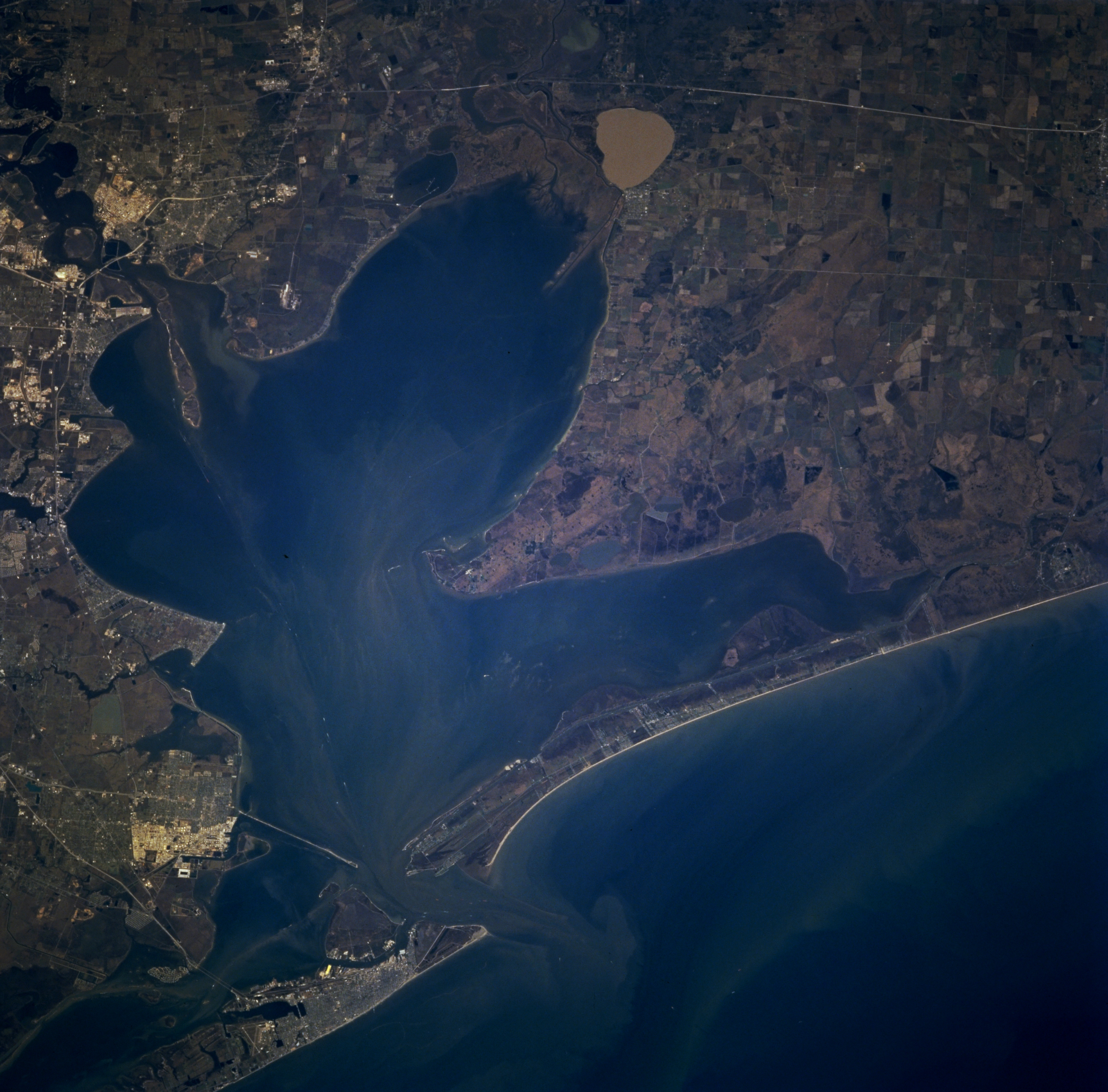
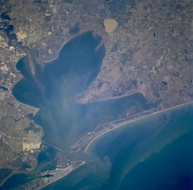
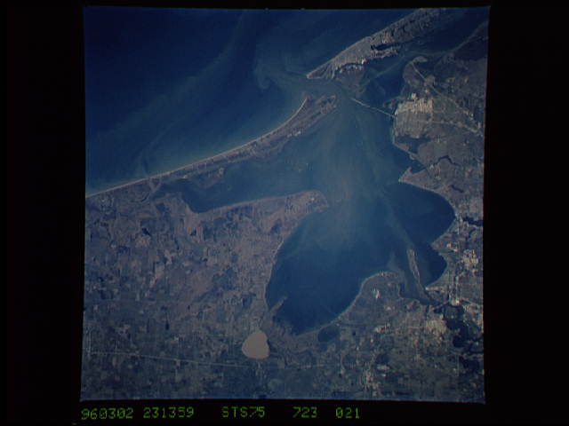
Image Caption: STS075-723-021 Galveston Bay, Texas, U.S.A. March 1996
A shallow, sediment-laden inlet of the Gulf of Mexico, Galveston Bay is featured in this north-northwest-looking, low-oblique photograph. During the last ice age, when sea levels were much lower than now, the mouths of the Trinity River and the San Jacinto River extended southeastward into the Gulf of Mexico. The rivers' estuaries filled and deposited sediment into a shallow basin that became Galveston Bay. As the ice melted, the sea level rose by almost 400 feet (122 meters) filling the present bay to an average depth of 12 feet (4 meters). The present mouth of the Trinity River (just below top center) is in Trinity Bay, upper Galveston Bay. The large sediment-laden, circular body of water east of the Trinity River mouth is Lake Anahuac. The former San Jacinto River estuary (below upper left) is now part of the Houston Ship Channel, which was completed in 1914. Reflective areas along the ship channel indicate numerous oil refineries and petrochemical plants. The completion of the Houston Ship Channel also included dredging a channel in Galveston Bay to the Gulf of Mexico 35 feet (11 meters) deep. Visible are Galveston on the eastern tip of Galveston Island and reflective oil refineries and petrochemical complexes northwest of Galveston in Texas City.
A shallow, sediment-laden inlet of the Gulf of Mexico, Galveston Bay is featured in this north-northwest-looking, low-oblique photograph. During the last ice age, when sea levels were much lower than now, the mouths of the Trinity River and the San Jacinto River extended southeastward into the Gulf of Mexico. The rivers' estuaries filled and deposited sediment into a shallow basin that became Galveston Bay. As the ice melted, the sea level rose by almost 400 feet (122 meters) filling the present bay to an average depth of 12 feet (4 meters). The present mouth of the Trinity River (just below top center) is in Trinity Bay, upper Galveston Bay. The large sediment-laden, circular body of water east of the Trinity River mouth is Lake Anahuac. The former San Jacinto River estuary (below upper left) is now part of the Houston Ship Channel, which was completed in 1914. Reflective areas along the ship channel indicate numerous oil refineries and petrochemical plants. The completion of the Houston Ship Channel also included dredging a channel in Galveston Bay to the Gulf of Mexico 35 feet (11 meters) deep. Visible are Galveston on the eastern tip of Galveston Island and reflective oil refineries and petrochemical complexes northwest of Galveston in Texas City.
