STS075-706-82
| NASA Photo ID | STS075-706-82 |
| Focal Length | 250mm |
| Date taken | 1996.03.02 |
| Time taken | 04:18:11 GMT |
Resolutions offered for this image:
5248 x 5248 pixels 640 x 640 pixels 5700 x 5900 pixels 500 x 518 pixels 640 x 480 pixels
5248 x 5248 pixels 640 x 640 pixels 5700 x 5900 pixels 500 x 518 pixels 640 x 480 pixels


Cloud masks available for this image:
Spacecraft nadir point: 26.3° N, 64.8° E
Photo center point: 24.5° N, 68.0° E
Photo center point by machine learning:
Photo center point: 24.5° N, 68.0° E
Photo center point by machine learning:
Nadir to Photo Center: Southeast
Spacecraft Altitude: 152 nautical miles (282km)
Country or Geographic Name: | PAKISTAN |
Features: | MOUTHS OF THE INDUS, SED. |
| Features Found Using Machine Learning: | |
Cloud Cover Percentage: | 0 (no clouds present) |
Sun Elevation Angle: | 28° |
Sun Azimuth: | 115° |
Camera: | Hasselblad |
Focal Length: | 250mm |
Camera Tilt: | Low Oblique |
Format: | 5046: Kodak, natural color positive, Lumiere 100/5046, ASA 100, standard base |
Film Exposure: | Normal |
| Additional Information | |
| Width | Height | Annotated | Cropped | Purpose | Links |
|---|---|---|---|---|---|
| 5248 pixels | 5248 pixels | No | No | Earth From Space collection | Download Image |
| 640 pixels | 640 pixels | No | No | Earth From Space collection | Download Image |
| 5700 pixels | 5900 pixels | No | No | Download Image | |
| 500 pixels | 518 pixels | No | No | Download Image | |
| 640 pixels | 480 pixels | No | No | Download Image |
Download Packaged File
Download a Google Earth KML for this Image
View photo footprint information
Download a GeoTIFF for this photo
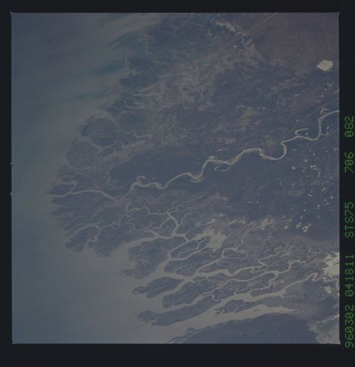
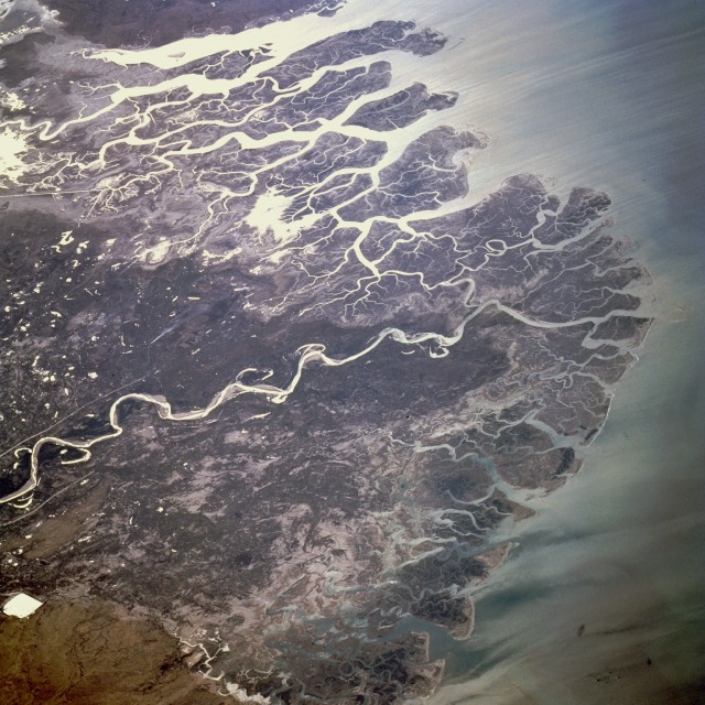
Image Caption: STS075-706-082 Indus River Delta, Pakistan February 1996
The delta of the Indus River, the longest river in southwest Asia, is the highlight of this south-southeast-looking, low-oblique photograph. Fed by snowmelt and glacial meltwater from the mountains of the Tibet Plateau, the Indus River flows 1900 miles (3055 kilometers) before emptying into the Arabian Sea. After leaving the Tibet Plateau, the river flows onto the Punjab Plains of western Pakistan and through a vast alluvial lowland where it receives its major tributary, the Panjnad (five streams), which carries the united waters of the Jhelum, Chenab, Ravi, Beas, and Sutlej. In this severely arid landscape, the rivers form precarious strips of fertile land. At the mouth of the Indus, east of Karachi (not visible in the photograph), the large, swampy Indus River Delta is formed, which, unlike deltas of many other rivers, is composed of clay and infertile soils. The largest flow of the Indus occurs between June and late September, the summer monsoon season. The waters are used primarily for irrigation of agricultural crops; dams have been built to provide flood control and hydroelectricity.
The delta of the Indus River, the longest river in southwest Asia, is the highlight of this south-southeast-looking, low-oblique photograph. Fed by snowmelt and glacial meltwater from the mountains of the Tibet Plateau, the Indus River flows 1900 miles (3055 kilometers) before emptying into the Arabian Sea. After leaving the Tibet Plateau, the river flows onto the Punjab Plains of western Pakistan and through a vast alluvial lowland where it receives its major tributary, the Panjnad (five streams), which carries the united waters of the Jhelum, Chenab, Ravi, Beas, and Sutlej. In this severely arid landscape, the rivers form precarious strips of fertile land. At the mouth of the Indus, east of Karachi (not visible in the photograph), the large, swampy Indus River Delta is formed, which, unlike deltas of many other rivers, is composed of clay and infertile soils. The largest flow of the Indus occurs between June and late September, the summer monsoon season. The waters are used primarily for irrigation of agricultural crops; dams have been built to provide flood control and hydroelectricity.
