STS074-706-23
| NASA Photo ID | STS074-706-23 |
| Focal Length | 100mm |
| Date taken | 1995.11.13 |
| Time taken | 08:38:02 GMT |
Resolutions offered for this image:
4079 x 4085 pixels 639 x 640 pixels 5700 x 5900 pixels 500 x 518 pixels 640 x 480 pixels 521 x 516 pixels
4079 x 4085 pixels 639 x 640 pixels 5700 x 5900 pixels 500 x 518 pixels 640 x 480 pixels 521 x 516 pixels

Cloud masks available for this image:
Spacecraft nadir point: 39.7° N, 88.4° E
Photo center point: 39.0° N, 88.0° E
Photo center point by machine learning:
Photo center point: 39.0° N, 88.0° E
Photo center point by machine learning:
Nadir to Photo Center: Southwest
Spacecraft Altitude: 176 nautical miles (326km)
Country or Geographic Name: | CHINA |
Features: | TAKLA MAKAN DESERT, DUNES |
| Features Found Using Machine Learning: | |
Cloud Cover Percentage: | 5 (1-10)% |
Sun Elevation Angle: | 21° |
Sun Azimuth: | 223° |
Camera: | Hasselblad |
Focal Length: | 100mm |
Camera Tilt: | 15 degrees |
Format: | 5046: Kodak, natural color positive, Lumiere 100/5046, ASA 100, standard base |
Film Exposure: | Normal |
| Additional Information | |
| Width | Height | Annotated | Cropped | Purpose | Links |
|---|---|---|---|---|---|
| 4079 pixels | 4085 pixels | No | No | Earth From Space collection | Download Image |
| 639 pixels | 640 pixels | No | No | Earth From Space collection | Download Image |
| 5700 pixels | 5900 pixels | No | No | Download Image | |
| 500 pixels | 518 pixels | No | No | Download Image | |
| 640 pixels | 480 pixels | No | No | Download Image | |
| 521 pixels | 516 pixels | Download Image |
Download Packaged File
Download a Google Earth KML for this Image
View photo footprint information
Download a GeoTIFF for this photo
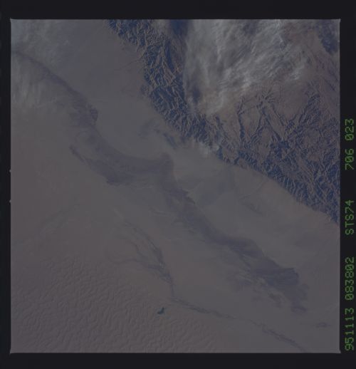
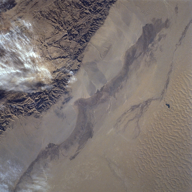
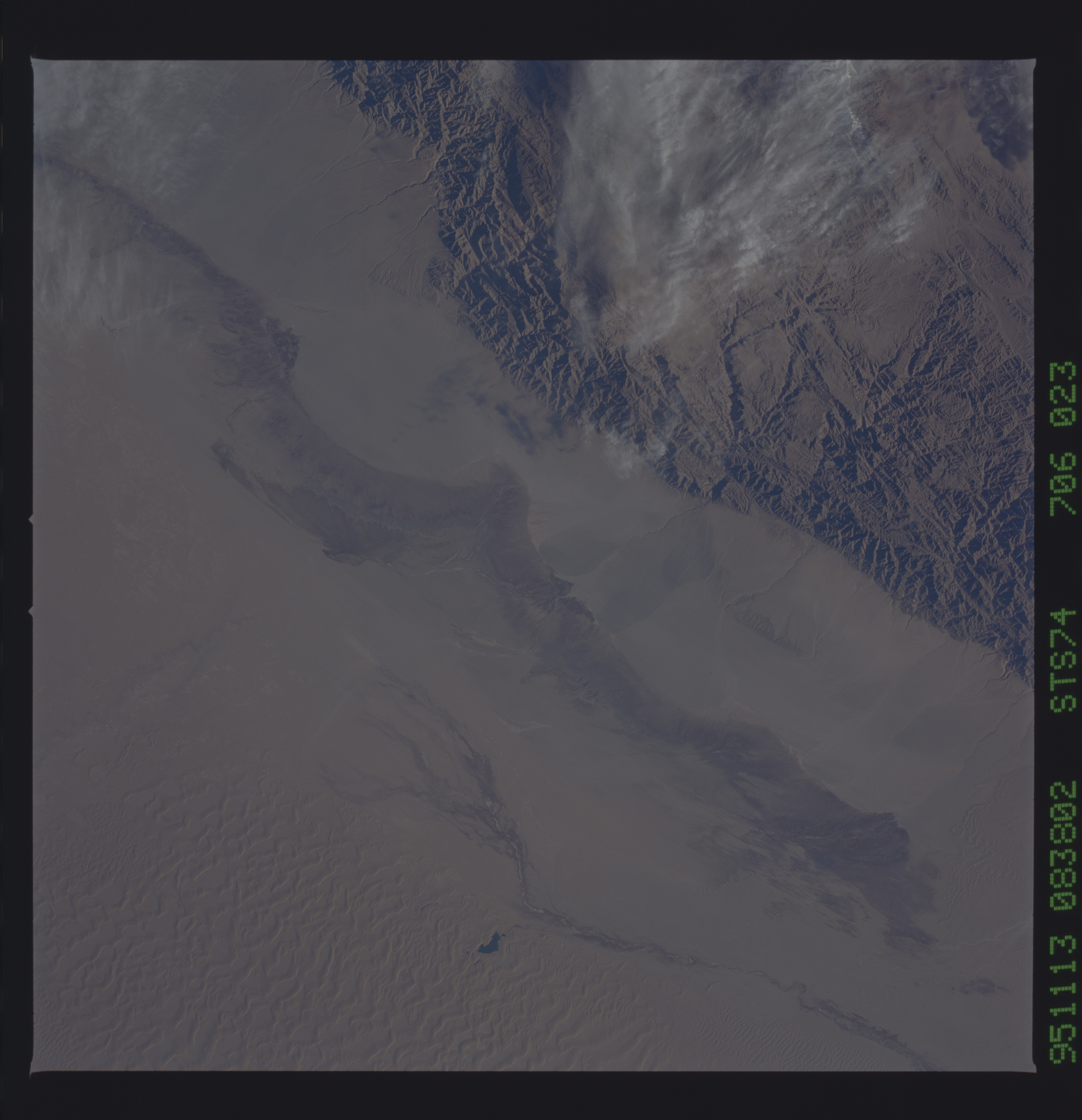
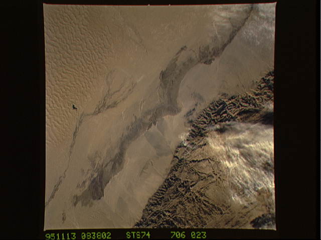
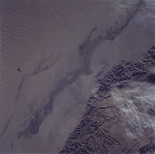
Image Caption: STS074-706-023 Takla Makan Desert, China November 1995
The rugged texture of the Altun Mountains (upper left) that forms part of the northern boundary of the Tibetan Plateau contrasts dramatically with the Takla Makan Desert of western China. Immediately north of the mountains there are large alluvial fans on the north facing slopes, gradually sloping downward in elevation. The elevations from the mountains to the desert floor vary from over 9000 feet (2743 meters) to slightly more than 3000 feet (914 meters) above sea level. The darker swath (diagonal, linear-looking feature) found at the base of the alluvial deposits has more moisture with sparse vegetation. Sand dunes and sand ridges are visible along the northern (lower right) margin of the image. The small dark feature (right center) appears to be a pool of water. The narrow dark swath that parallels the larger swath is a section of the southern route of the Silk Road that was once one of the major corridors linking western China with central Asia.
The rugged texture of the Altun Mountains (upper left) that forms part of the northern boundary of the Tibetan Plateau contrasts dramatically with the Takla Makan Desert of western China. Immediately north of the mountains there are large alluvial fans on the north facing slopes, gradually sloping downward in elevation. The elevations from the mountains to the desert floor vary from over 9000 feet (2743 meters) to slightly more than 3000 feet (914 meters) above sea level. The darker swath (diagonal, linear-looking feature) found at the base of the alluvial deposits has more moisture with sparse vegetation. Sand dunes and sand ridges are visible along the northern (lower right) margin of the image. The small dark feature (right center) appears to be a pool of water. The narrow dark swath that parallels the larger swath is a section of the southern route of the Silk Road that was once one of the major corridors linking western China with central Asia.
