STS073-746-56
| NASA Photo ID | STS073-746-56 |
| Focal Length | 250mm |
| Date taken | 1995.10.23 |
| Time taken | 13:52:37 GMT |
Resolutions offered for this image:
3872 x 3936 pixels 629 x 639 pixels 5700 x 5900 pixels 500 x 518 pixels 640 x 480 pixels 790 x 780 pixels
3872 x 3936 pixels 629 x 639 pixels 5700 x 5900 pixels 500 x 518 pixels 640 x 480 pixels 790 x 780 pixels


Cloud masks available for this image:
Spacecraft nadir point: 34.6° N, 86.5° W
Photo center point: 34.5° N, 87.0° W
Photo center point by machine learning:
Photo center point: 34.5° N, 87.0° W
Photo center point by machine learning:
Nadir to Photo Center: West
Spacecraft Altitude: 145 nautical miles (269km)
Country or Geographic Name: | USA-ALABAMA |
Features: | TN. RIVER, HUNTSVILLE, AGR |
| Features Found Using Machine Learning: | |
Cloud Cover Percentage: | 0 (no clouds present) |
Sun Elevation Angle: | 21° |
Sun Azimuth: | 121° |
Camera: | Hasselblad |
Focal Length: | 250mm |
Camera Tilt: | 12 degrees |
Format: | 2443: Kodak Aerochrome 2443, color IR, thin base, EA-5 process thru June 1999, E-6 process afterward |
Film Exposure: | Normal |
| Additional Information | |
| Width | Height | Annotated | Cropped | Purpose | Links |
|---|---|---|---|---|---|
| 3872 pixels | 3936 pixels | No | No | Earth From Space collection | Download Image |
| 629 pixels | 639 pixels | No | No | Earth From Space collection | Download Image |
| 5700 pixels | 5900 pixels | No | No | Download Image | |
| 500 pixels | 518 pixels | No | No | Download Image | |
| 640 pixels | 480 pixels | No | No | Download Image | |
| 790 pixels | 780 pixels | No | No | Download Image |
Download Packaged File
Download a Google Earth KML for this Image
View photo footprint information
Download a GeoTIFF for this photo
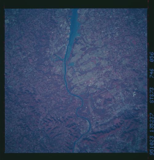
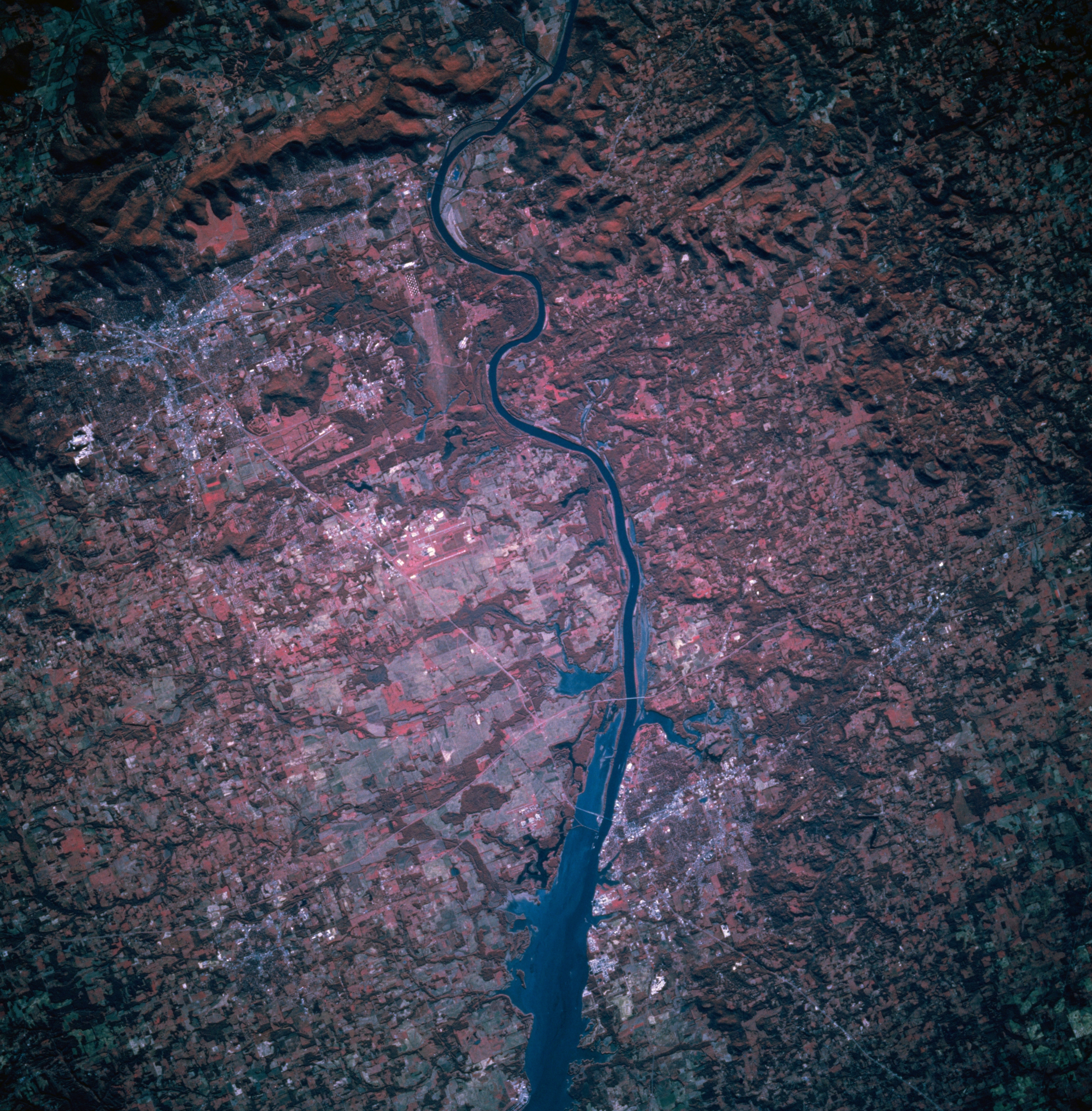
Image Caption: STS073-746-056 Tennessee River, North-Central Alabama, U.S.A. October 1995
This portion of the west-flowing Tennessee River widens as a result of Wheeler Dam that created Wheeler Lake east of Florence (not in this photograph). Barely discernible are Decatur along the south bank of the Tennessee River (near the bottom) and Huntsville to the northeast, whose eastward growth is severely limited by low, north-south-oriented mountains. Two highway bridges cross the Tennessee River near Decatur--easternmost Interstate Highway 65 and thin, light Interstate Highway 565 that connects Decatur and Huntsville. Visible are the dual runways of Huntsville-Madison County Airport (slightly left of center) midway between Huntsville and Decatur. Color infrared film (green vegetation is shown in various shades of red) helps delineate forested mountains, stream bottoms, and woodlands (deeper red) from lighter cultivated fields and grasslands.
This portion of the west-flowing Tennessee River widens as a result of Wheeler Dam that created Wheeler Lake east of Florence (not in this photograph). Barely discernible are Decatur along the south bank of the Tennessee River (near the bottom) and Huntsville to the northeast, whose eastward growth is severely limited by low, north-south-oriented mountains. Two highway bridges cross the Tennessee River near Decatur--easternmost Interstate Highway 65 and thin, light Interstate Highway 565 that connects Decatur and Huntsville. Visible are the dual runways of Huntsville-Madison County Airport (slightly left of center) midway between Huntsville and Decatur. Color infrared film (green vegetation is shown in various shades of red) helps delineate forested mountains, stream bottoms, and woodlands (deeper red) from lighter cultivated fields and grasslands.
