STS073-744-51
| NASA Photo ID | STS073-744-51 |
| Focal Length | 250mm |
| Date taken | 1995.10.27 |
| Time taken | 18:19:55 GMT |
Resolutions offered for this image:
3936 x 3904 pixels 639 x 634 pixels 5700 x 5900 pixels 500 x 518 pixels 640 x 480 pixels
3936 x 3904 pixels 639 x 634 pixels 5700 x 5900 pixels 500 x 518 pixels 640 x 480 pixels


Cloud masks available for this image:
Spacecraft nadir point: 33.4° N, 117.5° W
Photo center point: 34.0° N, 117.5° W
Photo center point by machine learning:
Photo center point: 34.0° N, 117.5° W
Photo center point by machine learning:
Nadir to Photo Center: North
Spacecraft Altitude: 144 nautical miles (267km)
Country or Geographic Name: | USA-CALIFORNIA |
Features: | CITIES, SAN GABRIEL MTS. |
| Features Found Using Machine Learning: | |
Cloud Cover Percentage: | 0 (no clouds present) |
Sun Elevation Angle: | 41° |
Sun Azimuth: | 156° |
Camera: | Hasselblad |
Focal Length: | 250mm |
Camera Tilt: | 14 degrees |
Format: | 2443: Kodak Aerochrome 2443, color IR, thin base, EA-5 process thru June 1999, E-6 process afterward |
Film Exposure: | Normal |
| Additional Information | |
| Width | Height | Annotated | Cropped | Purpose | Links |
|---|---|---|---|---|---|
| 3936 pixels | 3904 pixels | No | No | Earth From Space collection | Download Image |
| 639 pixels | 634 pixels | No | No | Earth From Space collection | Download Image |
| 5700 pixels | 5900 pixels | No | No | Download Image | |
| 500 pixels | 518 pixels | No | No | Download Image | |
| 640 pixels | 480 pixels | No | No | Download Image |
Download Packaged File
Download a Google Earth KML for this Image
View photo footprint information
Download a GeoTIFF for this photo
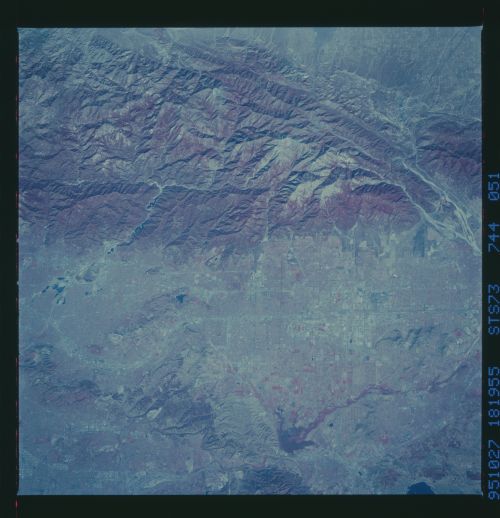
Image Caption: STS073-744-051 Ontario, California, U.S.A. October 1995
The rugged eastern edge of the San Gabriel Mountains contrasts with the urban corridor to the south. Several major highways and the street grid patterns of Covina, Pomona, Ontario, and Fontana are evident in this color infrared photograph. Discernible is a small part of the San Andreas Fault in the northeastern quadrant. Other features include the southwest-flowing Santa Ana River (southeast side of the photograph), the Chino Hills and the Puente Hills (southwest edge of the photograph), and the tributary streams of the San Gabriel River that have cut canyons through the San Gabriel Mountains (northern part of the photograph).
The rugged eastern edge of the San Gabriel Mountains contrasts with the urban corridor to the south. Several major highways and the street grid patterns of Covina, Pomona, Ontario, and Fontana are evident in this color infrared photograph. Discernible is a small part of the San Andreas Fault in the northeastern quadrant. Other features include the southwest-flowing Santa Ana River (southeast side of the photograph), the Chino Hills and the Puente Hills (southwest edge of the photograph), and the tributary streams of the San Gabriel River that have cut canyons through the San Gabriel Mountains (northern part of the photograph).
