STS073-741-67
| NASA Photo ID | STS073-741-67 |
| Focal Length | 250mm |
| Date taken | 1995.10.24 |
| Time taken | 13:53:17 GMT |
Resolutions offered for this image:
3936 x 3904 pixels 639 x 634 pixels 5700 x 5900 pixels 500 x 518 pixels 640 x 480 pixels
3936 x 3904 pixels 639 x 634 pixels 5700 x 5900 pixels 500 x 518 pixels 640 x 480 pixels

Cloud masks available for this image:
Spacecraft nadir point: 38.6° N, 73.9° W
Photo center point: 39.5° N, 74.5° W
Photo center point by machine learning:
Photo center point: 39.5° N, 74.5° W
Photo center point by machine learning:
Nadir to Photo Center: Northwest
Spacecraft Altitude: 144 nautical miles (267km)
Country or Geographic Name: | USA-NEW JERSEY |
Features: | COAST, FOR., ATLANTIC CITY |
| Features Found Using Machine Learning: | |
Cloud Cover Percentage: | 0 (no clouds present) |
Sun Elevation Angle: | 27° |
Sun Azimuth: | 133° |
Camera: | Hasselblad |
Focal Length: | 250mm |
Camera Tilt: | 24 degrees |
Format: | 2443: Kodak Aerochrome 2443, color IR, thin base, EA-5 process thru June 1999, E-6 process afterward |
Film Exposure: | Normal |
| Additional Information | |
| Width | Height | Annotated | Cropped | Purpose | Links |
|---|---|---|---|---|---|
| 3936 pixels | 3904 pixels | No | No | Earth From Space collection | Download Image |
| 639 pixels | 634 pixels | No | No | Earth From Space collection | Download Image |
| 5700 pixels | 5900 pixels | No | No | Download Image | |
| 500 pixels | 518 pixels | No | No | Download Image | |
| 640 pixels | 480 pixels | No | No | Download Image |
Download Packaged File
Download a Google Earth KML for this Image
View photo footprint information
Download a GeoTIFF for this photo
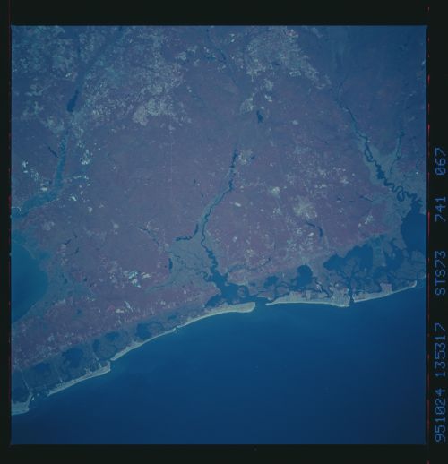
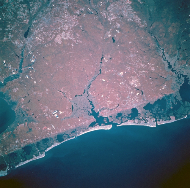
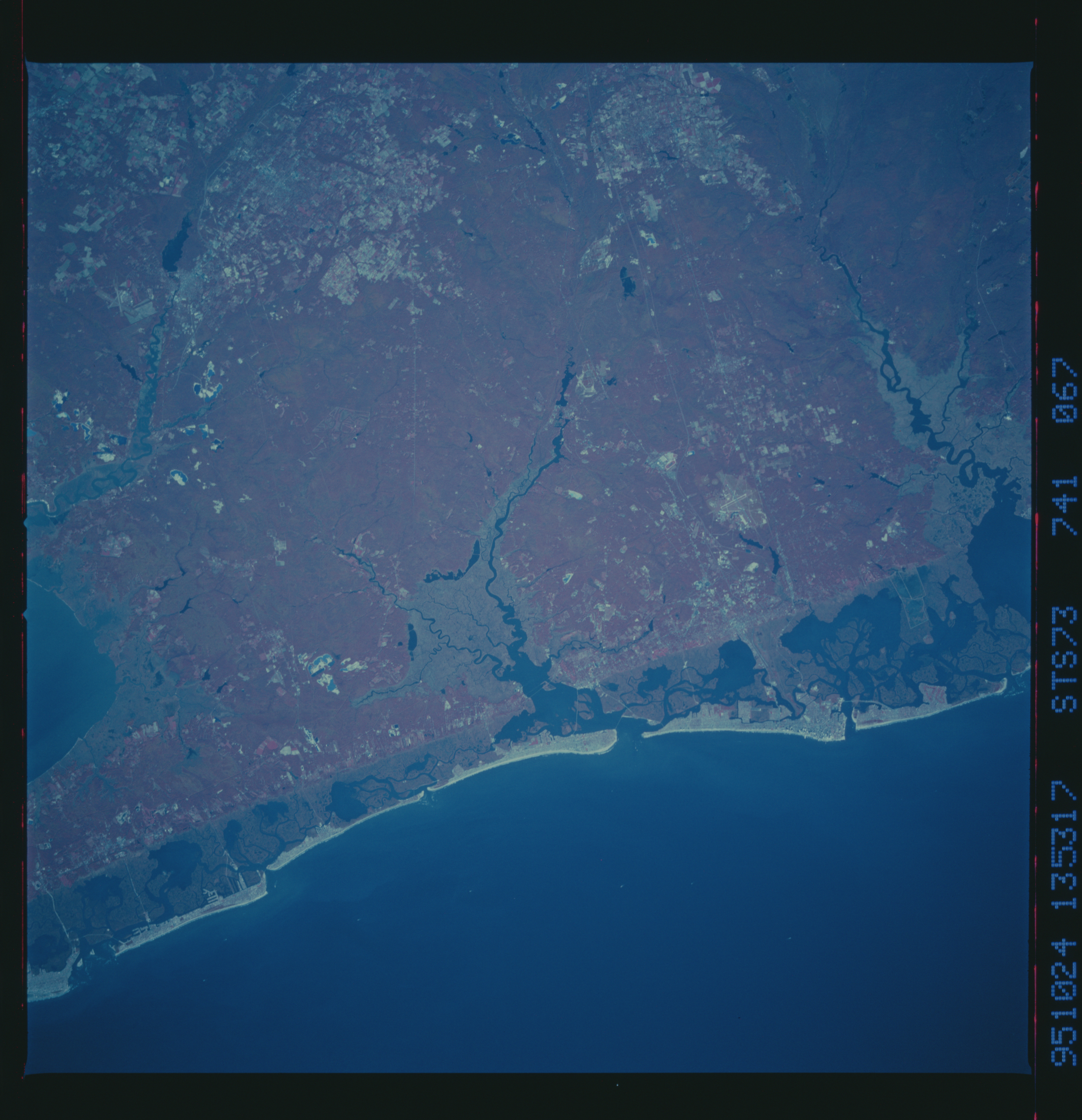
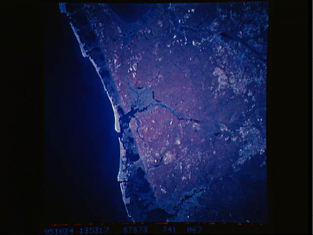
Image Caption: STS073-741-067 Atlantic City Area, New Jersey, U.S.A. October 1995
This is a color infrared image of the Atlantic City area in coastal, southeast New Jersey. The bright red area that dominates the scene is a sizable region of elevated forested land. This densely wooded area is interrupted by three major drainage features in this scene: the Maurice River that flows southward into Delaware Bay (left), the Great Egg Harbor River (darker drainage in the middle of the picture), and the Mullica River (dark, winding feature along the right edge of the image). The sharp linear boundary that extends northeast-southwest across the scene along the coast is a physiographic boundary between the coastal barrier beach-lagoon landscape and the forested uplands. The darker red region just inland from the brighter sandy beach is the marsh vegetation in the coastal lagoons. The sandy beaches of southeast New Jersey have been a major tourist attraction for almost 100 years. The general location of Atlantic City can be identified near the right middle edge of the image where a broad section of the beach extends into the Atlantic Ocean.
This is a color infrared image of the Atlantic City area in coastal, southeast New Jersey. The bright red area that dominates the scene is a sizable region of elevated forested land. This densely wooded area is interrupted by three major drainage features in this scene: the Maurice River that flows southward into Delaware Bay (left), the Great Egg Harbor River (darker drainage in the middle of the picture), and the Mullica River (dark, winding feature along the right edge of the image). The sharp linear boundary that extends northeast-southwest across the scene along the coast is a physiographic boundary between the coastal barrier beach-lagoon landscape and the forested uplands. The darker red region just inland from the brighter sandy beach is the marsh vegetation in the coastal lagoons. The sandy beaches of southeast New Jersey have been a major tourist attraction for almost 100 years. The general location of Atlantic City can be identified near the right middle edge of the image where a broad section of the beach extends into the Atlantic Ocean.
