STS073-708-82
| NASA Photo ID | STS073-708-82 |
| Focal Length | 250mm |
| Date taken | 1995.10.26 |
| Time taken | 09:27:11 GMT |


Cloud masks available for this image:
Spacecraft nadir point: 31.3° N, 32.2° E
Photo center point: 31.5° N, 31.5° E
Photo center point by machine learning:
Photo center point: 31.5° N, 31.5° E
Photo center point by machine learning:
Nadir to Photo Center: West
Spacecraft Altitude: 145 nautical miles (269km)
Camera: | Hasselblad |
Focal Length: | 250mm |
Camera Tilt: | 17 degrees |
Format: | 5046: Kodak, natural color positive, Lumiere 100/5046, ASA 100, standard base |
Film Exposure: | Normal |
| Additional Information | |
| Width | Height | Annotated | Cropped | Purpose | Links |
|---|---|---|---|---|---|
| 5700 pixels | 5900 pixels | No | No | Download Image | |
| 500 pixels | 518 pixels | No | No | Download Image | |
| 640 pixels | 480 pixels | No | No | Download Image |
Download Packaged File
Download a Google Earth KML for this Image
View photo footprint information
Download a GeoTIFF for this photo
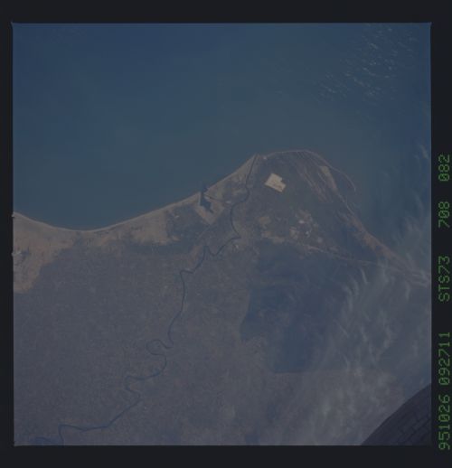
Image Caption: The Damietta exit of the Nile river is the smaller of
the two main branches that form the Nile delta. The Nile is the
longest river in the world at 4160 miles. The delta has been under
intense agriculture since pre-historic times. The High Aswan dam which
was completed in 1970, has reduced the sediment flow into the delta
causing subsidence and reduced nutrient transport. The photography
shows very little sediment entering the Mediterranean Sea. The main
flood season is in the Spring. Egypt has put programs into place to
improve the agriculture in the delta and has tried to expand the
productive lands into the desert. Lake Manzala is on the Eastern side
of the river. An Egyptian military base is located to the West of the
Mouth. The city of Damietta is located South of the river mouth
