STS070-729-67
| NASA Photo ID | STS070-729-67 |
| Focal Length | 250mm |
| Date taken | 1995.07.16 |
| Time taken | 15:54:18 GMT |
Resolutions offered for this image:
4019 x 4019 pixels 640 x 640 pixels 5700 x 5900 pixels 500 x 518 pixels 640 x 480 pixels
4019 x 4019 pixels 640 x 640 pixels 5700 x 5900 pixels 500 x 518 pixels 640 x 480 pixels
Cloud masks available for this image:
Spacecraft nadir point: 12.2° N, 72.1° W
Photo center point: 12.0° N, 70.0° W
Photo center point by machine learning:
Photo center point: 12.0° N, 70.0° W
Photo center point by machine learning:
Nadir to Photo Center: East
Spacecraft Altitude: 153 nautical miles (283km)
Country or Geographic Name: | VENEZUELA |
Features: | PARAGUANA PEN., CORO G. |
| Features Found Using Machine Learning: | |
Cloud Cover Percentage: | 5 (1-10)% |
Sun Elevation Angle: | 73° |
Sun Azimuth: | 55° |
Camera: | Hasselblad |
Focal Length: | 250mm |
Camera Tilt: | 40 degrees |
Format: | 5046: Kodak, natural color positive, Lumiere 100/5046, ASA 100, standard base |
Film Exposure: | Normal |
| Additional Information | |
| Width | Height | Annotated | Cropped | Purpose | Links |
|---|---|---|---|---|---|
| 4019 pixels | 4019 pixels | No | No | Earth From Space collection | Download Image |
| 640 pixels | 640 pixels | No | No | Earth From Space collection | Download Image |
| 5700 pixels | 5900 pixels | No | No | Download Image | |
| 500 pixels | 518 pixels | No | No | Download Image | |
| 640 pixels | 480 pixels | No | No | Download Image |
Download Packaged File
Download a Google Earth KML for this Image
View photo footprint information
Download a GeoTIFF for this photo
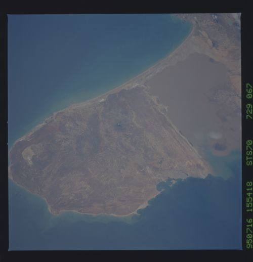
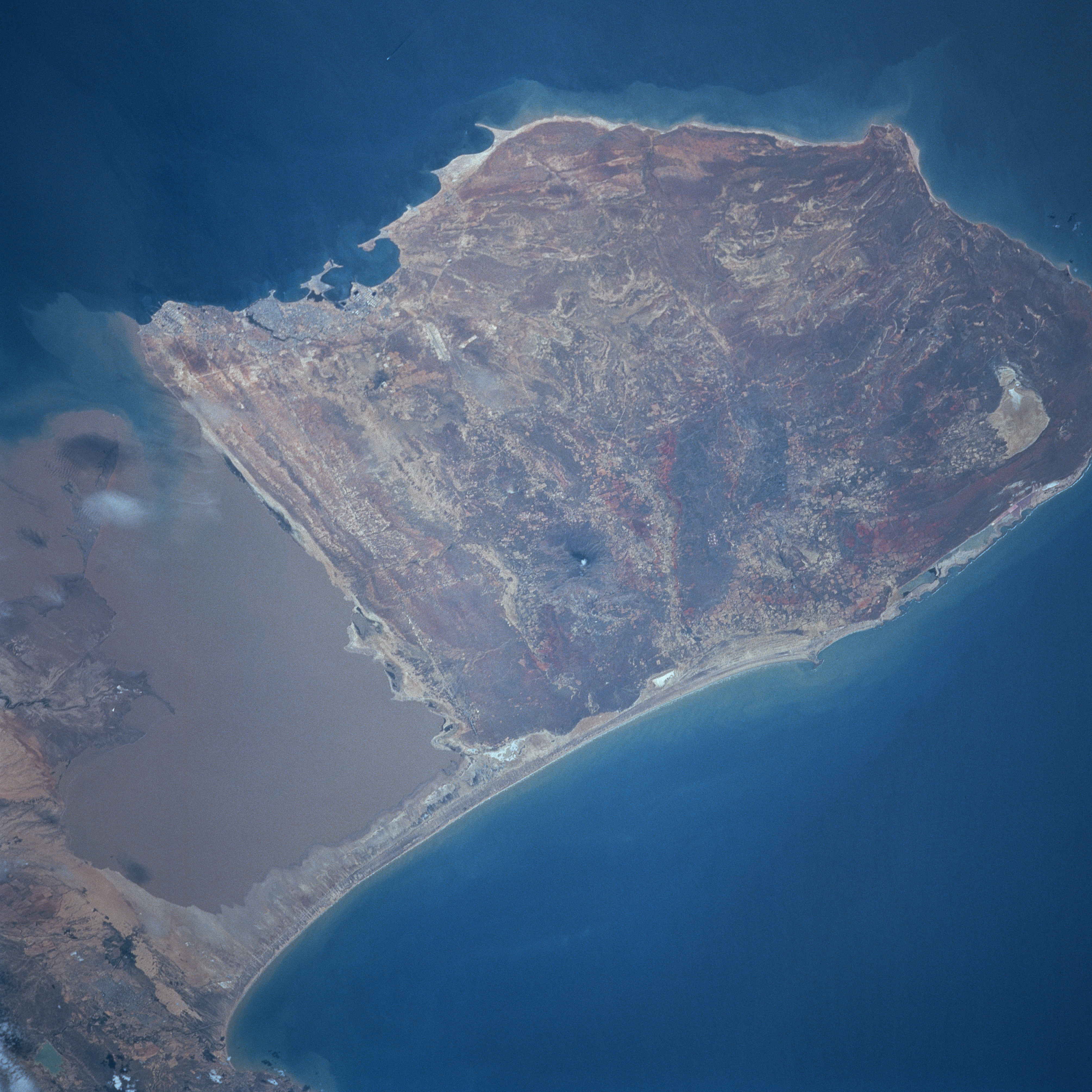
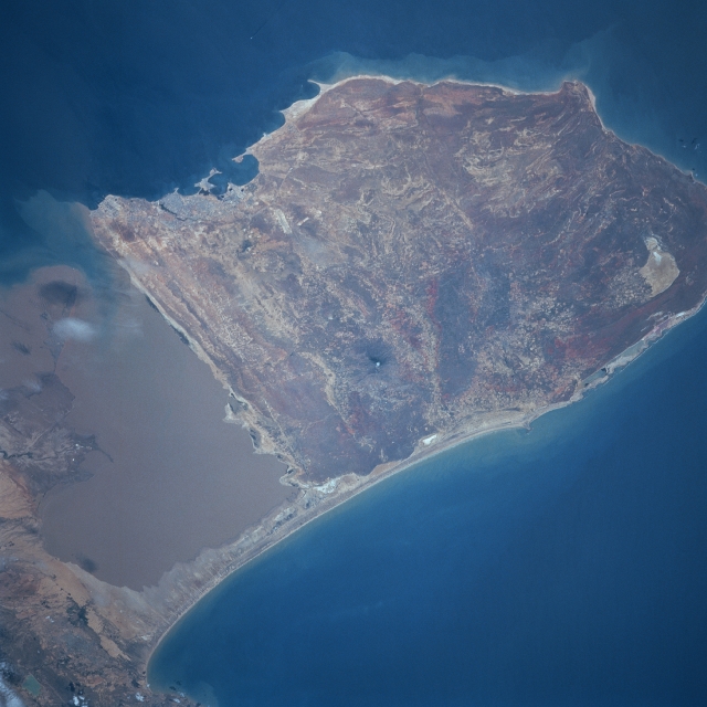
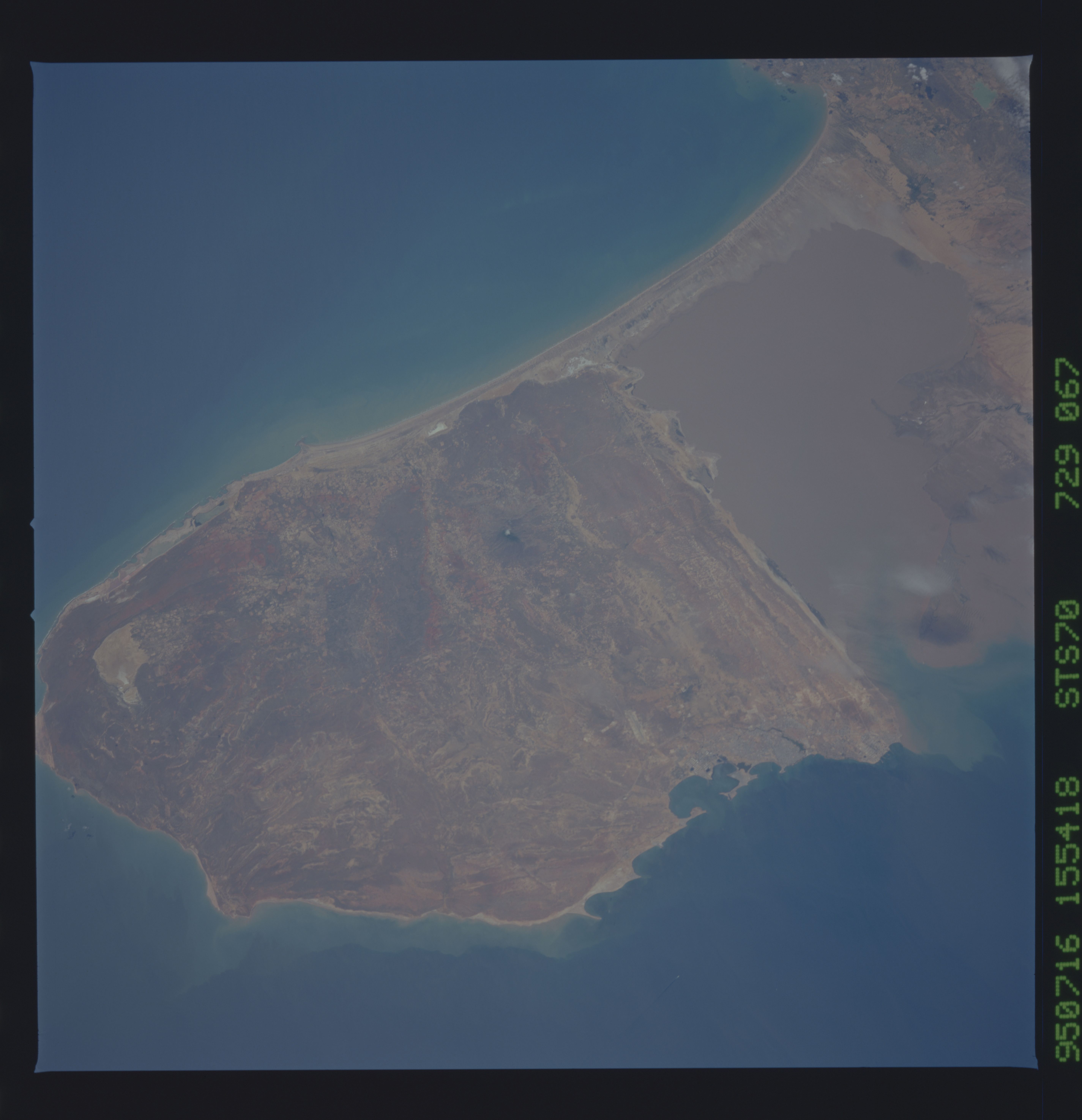
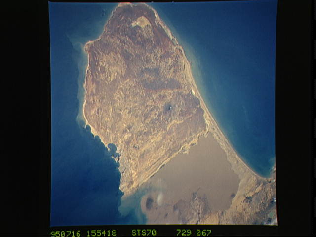
Image Caption: STS070-729-67 Paraguana Peninsula, Venezuela July 1995
The dry, sparsely vegetated, and windswept Paraguana Peninsula is featured in this east-southeast-looking view. Major oil refineries are common along the southwestern coast in the cities of Punta Cardon and Punto Fijo. Numerous sandy beaches dot the north and the eastern coasts. The peninsula is noted as a tourist mecca, offering some of the best windsurfing in the world. Near the center of the view, the rather dark area is the 2723 foot (830 meters) high Mount Santa Ana. Elsewhere the sediment-laden waters of the Gulf of Coro are visible south of the main area of the peninsula, in the right center portion of the image. A small delta extending into the gulf is also visible. Finally, in the upper right portion of the image, the city of Coro can be identified.
The dry, sparsely vegetated, and windswept Paraguana Peninsula is featured in this east-southeast-looking view. Major oil refineries are common along the southwestern coast in the cities of Punta Cardon and Punto Fijo. Numerous sandy beaches dot the north and the eastern coasts. The peninsula is noted as a tourist mecca, offering some of the best windsurfing in the world. Near the center of the view, the rather dark area is the 2723 foot (830 meters) high Mount Santa Ana. Elsewhere the sediment-laden waters of the Gulf of Coro are visible south of the main area of the peninsula, in the right center portion of the image. A small delta extending into the gulf is also visible. Finally, in the upper right portion of the image, the city of Coro can be identified.
