STS070-712-63
| NASA Photo ID | STS070-712-63 |
| Focal Length | 250mm |
| Date taken | 1995.07.16 |
| Time taken | 14:15:13 GMT |
Resolutions offered for this image:
3872 x 3872 pixels 639 x 639 pixels 5700 x 5900 pixels 500 x 518 pixels 640 x 480 pixels
3872 x 3872 pixels 639 x 639 pixels 5700 x 5900 pixels 500 x 518 pixels 640 x 480 pixels


Cloud masks available for this image:
Spacecraft nadir point: 24.9° N, 81.6° W
Photo center point: 26.5° N, 82.0° W
Photo center point by machine learning:
Photo center point: 26.5° N, 82.0° W
Photo center point by machine learning:
Nadir to Photo Center: North
Spacecraft Altitude: 155 nautical miles (287km)
Country or Geographic Name: | USA-FLORIDA |
Features: | FORT MYERS, HARBOR, IS. |
| Features Found Using Machine Learning: | |
Cloud Cover Percentage: | 0 (no clouds present) |
Sun Elevation Angle: | 45° |
Sun Azimuth: | 84° |
Camera: | Hasselblad |
Focal Length: | 250mm |
Camera Tilt: | 32 degrees |
Format: | 5046: Kodak, natural color positive, Lumiere 100/5046, ASA 100, standard base |
Film Exposure: | Normal |
| Additional Information | |
| Width | Height | Annotated | Cropped | Purpose | Links |
|---|---|---|---|---|---|
| 3872 pixels | 3872 pixels | No | No | Earth From Space collection | Download Image |
| 639 pixels | 639 pixels | No | No | Earth From Space collection | Download Image |
| 5700 pixels | 5900 pixels | No | No | Download Image | |
| 500 pixels | 518 pixels | No | No | Download Image | |
| 640 pixels | 480 pixels | No | No | Download Image |
Download Packaged File
Download a Google Earth KML for this Image
View photo footprint information
Download a GeoTIFF for this photo
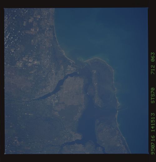
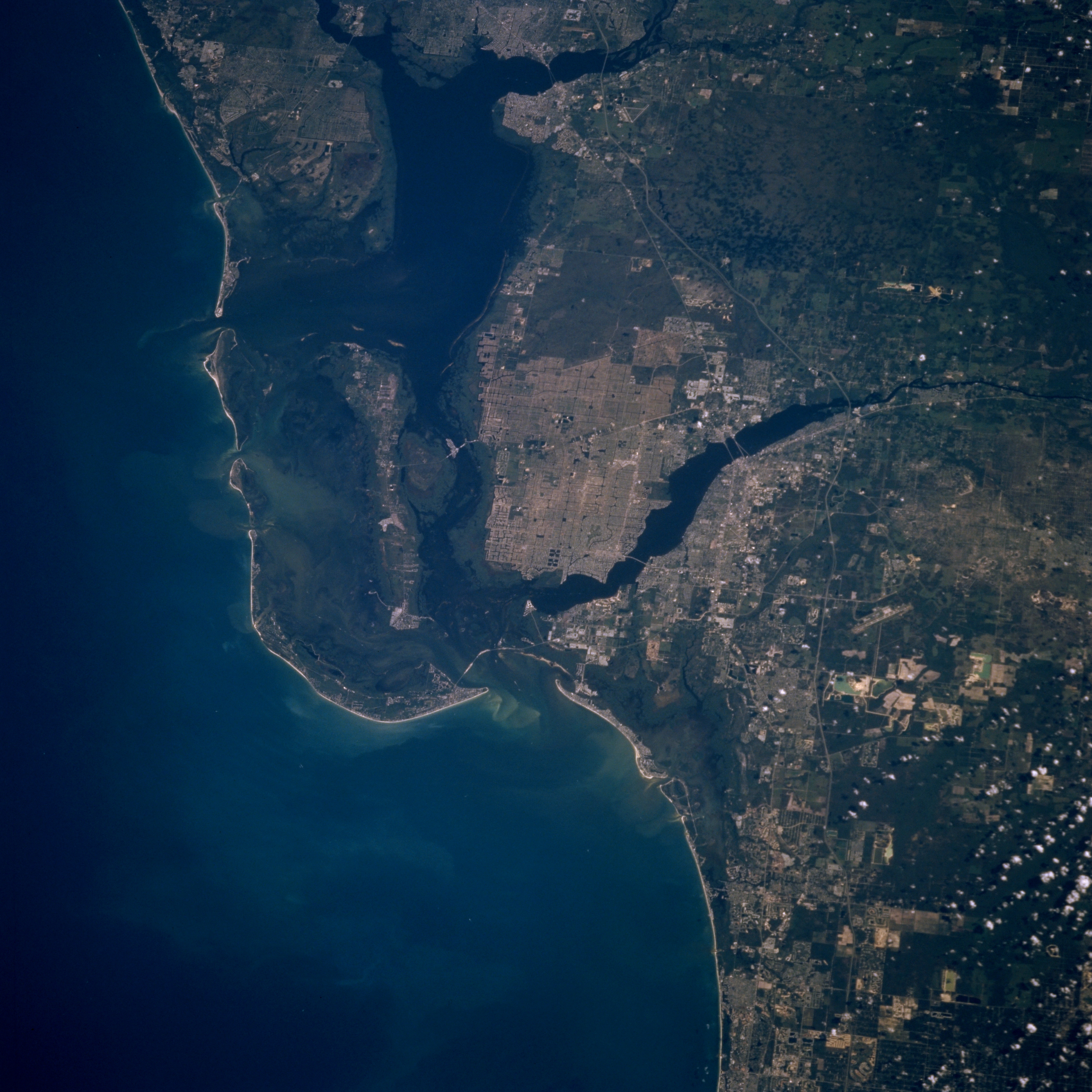
Image Caption: STS070-712-063 Fort Myers, Florida, U.S.A. July 1995
This photograph covers essentially the same area as STS069-718-0053. Readily identifiable from north to south are the mouth of the Peace River at Port Charlotte; Charlotte Harbor; Sanibel and Pine Islands; the expanding cities of North Fort Myers, Cape Coral, and Fort Myers (south of the Caloosahatchee River); and urban and commercial developments south of Fort Myers. Interstate Highway 75 and segments of U.S. Highway 41 are discernible.
This photograph covers essentially the same area as STS069-718-0053. Readily identifiable from north to south are the mouth of the Peace River at Port Charlotte; Charlotte Harbor; Sanibel and Pine Islands; the expanding cities of North Fort Myers, Cape Coral, and Fort Myers (south of the Caloosahatchee River); and urban and commercial developments south of Fort Myers. Interstate Highway 75 and segments of U.S. Highway 41 are discernible.
