STS068-264-6
| NASA Photo ID | STS068-264-6 |
| Focal Length | 100mm |
| Date taken | 1994.10.02 |
| Time taken | 18:32:06 GMT |
Resolutions offered for this image:
3840 x 3904 pixels 629 x 639 pixels 5700 x 5900 pixels 500 x 518 pixels 640 x 480 pixels
3840 x 3904 pixels 629 x 639 pixels 5700 x 5900 pixels 500 x 518 pixels 640 x 480 pixels
Cloud masks available for this image:
Spacecraft nadir point: 39.9° N, 74.9° W
Photo center point: 39.5° N, 76.0° W
Photo center point by machine learning:
Photo center point: 39.5° N, 76.0° W
Photo center point by machine learning:
Nadir to Photo Center: West
Spacecraft Altitude: 118 nautical miles (219km)
Country or Geographic Name: | USA-MARYLAND |
Features: | CHESAPEAKE, DELAWARE BAY |
| Features Found Using Machine Learning: | |
Cloud Cover Percentage: | 10 (1-10)% |
Sun Elevation Angle: | 41° |
Sun Azimuth: | 215° |
Camera: | Hasselblad |
Focal Length: | 100mm |
Camera Tilt: | 31 degrees |
Format: | 5046: Kodak, natural color positive, Lumiere 100/5046, ASA 100, standard base |
Film Exposure: | Normal |
| Additional Information | |
| Width | Height | Annotated | Cropped | Purpose | Links |
|---|---|---|---|---|---|
| 3840 pixels | 3904 pixels | No | No | Earth From Space collection | Download Image |
| 629 pixels | 639 pixels | No | No | Earth From Space collection | Download Image |
| 5700 pixels | 5900 pixels | No | No | Download Image | |
| 500 pixels | 518 pixels | No | No | Download Image | |
| 640 pixels | 480 pixels | No | No | Download Image |
Download Packaged File
Download a Google Earth KML for this Image
View photo footprint information
Download a GeoTIFF for this photo
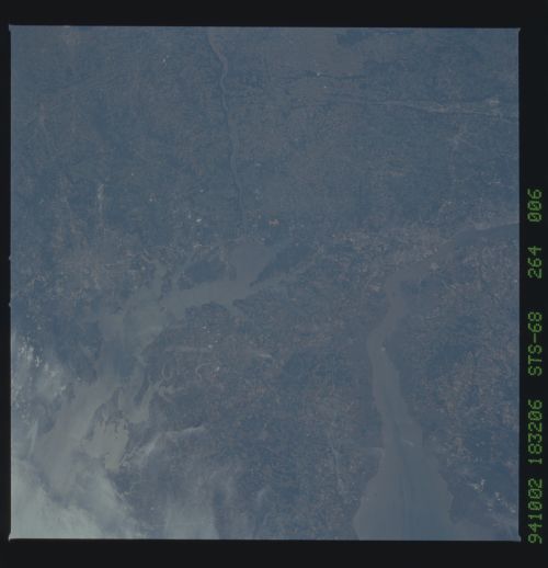
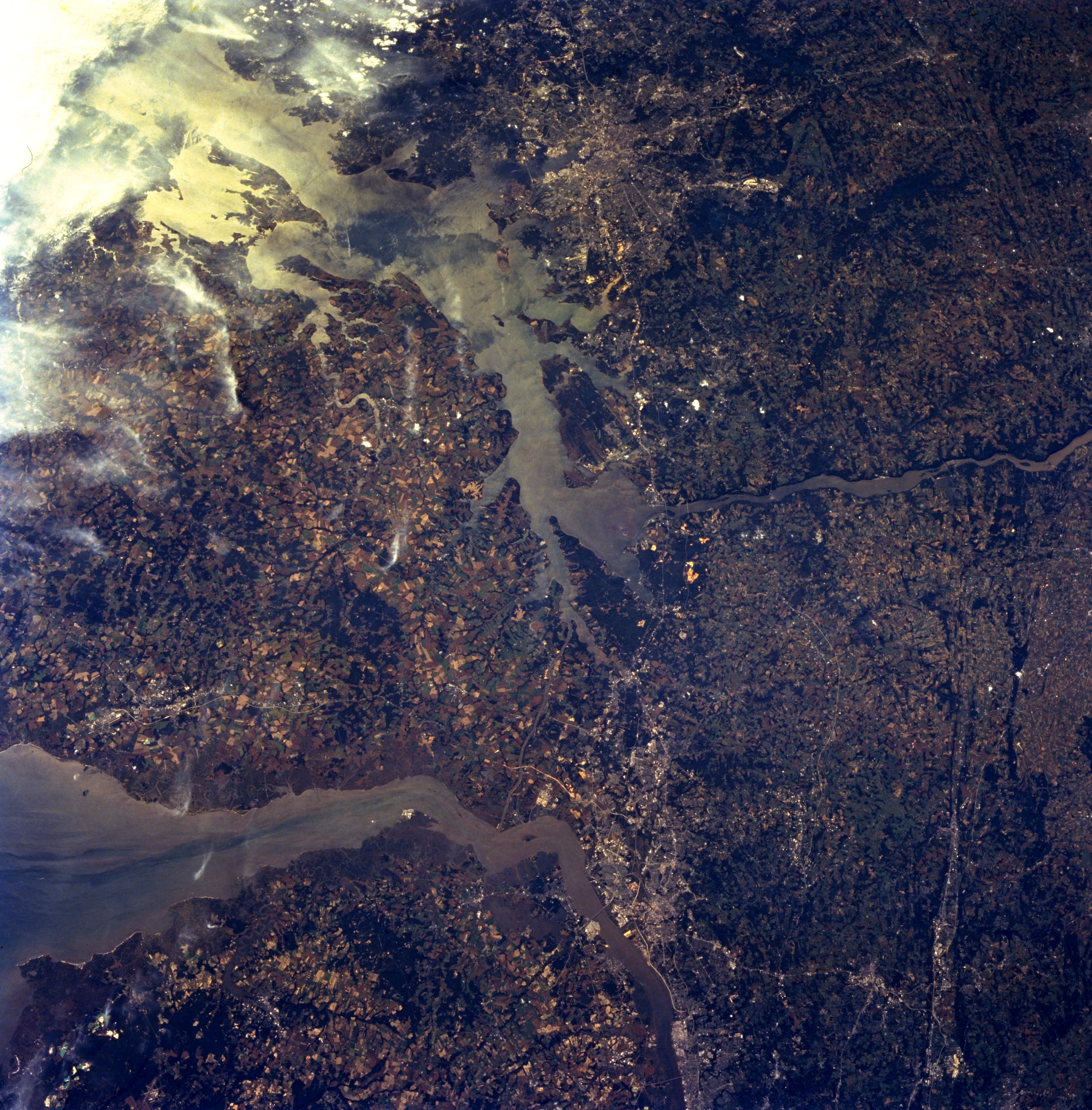
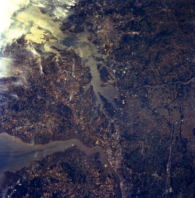
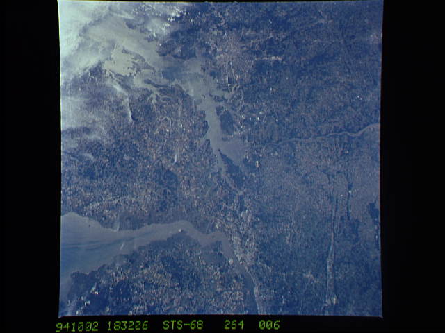
Image Caption: STS068-264-006 Delaware And Upper Chesapeake Bays, Maryland, U.S.A. October 1994
Delaware and upper Chesapeake Bays can be seen in this southwest-looking, low-oblique view. The Susquehanna River enters the scene near right of center (northwest) and flows into Chesapeake Bay (center of the image). The sediment-laden Delaware River enters the scene at the bottom center of the image and flows past Wilmington, Delaware (western shore). The river then turns southeastward into Delaware Bay, an estuary 52 miles (84 km) long, located between the states of New Jersey (bottom left) and Delaware (left center). The Chesapeake and Delaware Canal, part of the Intracoastal Waterway, which connects the Delaware River with the Chesapeake Bay, is barely discernible to the south of Wilmington. Wilmington is a port of entry handling considerable domestic and foreign shipping. The city has vast shipyards and is a large chemical industrial center. Towards the top of the image is the city of Baltimore.
Delaware and upper Chesapeake Bays can be seen in this southwest-looking, low-oblique view. The Susquehanna River enters the scene near right of center (northwest) and flows into Chesapeake Bay (center of the image). The sediment-laden Delaware River enters the scene at the bottom center of the image and flows past Wilmington, Delaware (western shore). The river then turns southeastward into Delaware Bay, an estuary 52 miles (84 km) long, located between the states of New Jersey (bottom left) and Delaware (left center). The Chesapeake and Delaware Canal, part of the Intracoastal Waterway, which connects the Delaware River with the Chesapeake Bay, is barely discernible to the south of Wilmington. Wilmington is a port of entry handling considerable domestic and foreign shipping. The city has vast shipyards and is a large chemical industrial center. Towards the top of the image is the city of Baltimore.
