STS068-214-43
| NASA Photo ID | STS068-214-43 |
| Focal Length | 250mm |
| Date taken | 1994.10.01 |
| Time taken | 00:56:04 GMT |
Resolutions offered for this image:
5294 x 5294 pixels 640 x 640 pixels 5700 x 5900 pixels 500 x 518 pixels 640 x 480 pixels
5294 x 5294 pixels 640 x 640 pixels 5700 x 5900 pixels 500 x 518 pixels 640 x 480 pixels


Cloud masks available for this image:
Spacecraft nadir point: 56.7° N, 152.8° E
Photo center point: 55.0° N, 162.0° E
Photo center point by machine learning:
Photo center point: 55.0° N, 162.0° E
Photo center point by machine learning:
Nadir to Photo Center: East
Spacecraft Altitude: 118 nautical miles (219km)
Country or Geographic Name: | RUSSIAN FEDERATION |
Features: | PAN-VOL. DUST PLUME, CL. |
| Features Found Using Machine Learning: | |
Cloud Cover Percentage: | 15 (11-25)% |
Sun Elevation Angle: | 30° |
Sun Azimuth: | 168° |
Camera: | Hasselblad |
Focal Length: | 250mm |
Camera Tilt: | High Oblique |
Format: | 5046: Kodak, natural color positive, Lumiere 100/5046, ASA 100, standard base |
Film Exposure: | Normal |
| Additional Information | |
| Width | Height | Annotated | Cropped | Purpose | Links |
|---|---|---|---|---|---|
| 5294 pixels | 5294 pixels | No | No | Earth From Space collection | Download Image |
| 640 pixels | 640 pixels | No | No | Earth From Space collection | Download Image |
| 5700 pixels | 5900 pixels | No | No | Download Image | |
| 500 pixels | 518 pixels | No | No | Download Image | |
| 640 pixels | 480 pixels | No | No | Download Image |
Download Packaged File
Download a Google Earth KML for this Image
View photo footprint information
Download a GeoTIFF for this photo
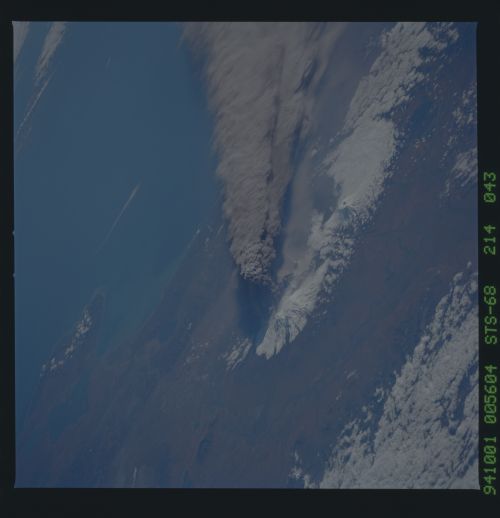
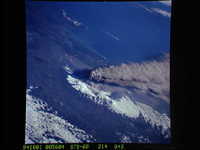
Image Caption: STS068-214-043 Klyuchevskaya Volcano, Kamchatka Peninsula, Russia October 1994
On October 1, 1994, Space Shuttle astronauts successfully took a series of photographs of Klyuchevskaya Volcano erupting near the east-central coast of Kamchatka Peninsula in Russia. This southeast-looking photograph was made as the spacecraft was approaching the volcano from the west. The dark, ash-laden plume rose to an estimated altitude of 6 to 9 miles (10 to 14 kilometers) and drifted southeast of the volcano. Both lava and ash explosions occurred during this eruption. Klyuchevskaya Volcano is reported to be Kamchatka's highest [15 584 feet (4750 meters) above sea level] and most active volcano. Small steam or ash plumes are also visible from subsidiary vents or craters immediately south of the major eruption zone. Other snow-covered stratovolcanoes appear in this complex cluster of volcanoes. The Kamchatka River Valley is seen in the foreground--first as it flows northward, then as it flows eastward, finally emptying into Kamchatka Bay. The blue waters of the Bering Sea are off the east coast of Kamchatka Peninsula. (Refer to photograph STS-068-273-033, which was taken on October 3, 1994, just 2 days after the major eruption occurred, for a near-vertical view of this volcanic complex.)
On October 1, 1994, Space Shuttle astronauts successfully took a series of photographs of Klyuchevskaya Volcano erupting near the east-central coast of Kamchatka Peninsula in Russia. This southeast-looking photograph was made as the spacecraft was approaching the volcano from the west. The dark, ash-laden plume rose to an estimated altitude of 6 to 9 miles (10 to 14 kilometers) and drifted southeast of the volcano. Both lava and ash explosions occurred during this eruption. Klyuchevskaya Volcano is reported to be Kamchatka's highest [15 584 feet (4750 meters) above sea level] and most active volcano. Small steam or ash plumes are also visible from subsidiary vents or craters immediately south of the major eruption zone. Other snow-covered stratovolcanoes appear in this complex cluster of volcanoes. The Kamchatka River Valley is seen in the foreground--first as it flows northward, then as it flows eastward, finally emptying into Kamchatka Bay. The blue waters of the Bering Sea are off the east coast of Kamchatka Peninsula. (Refer to photograph STS-068-273-033, which was taken on October 3, 1994, just 2 days after the major eruption occurred, for a near-vertical view of this volcanic complex.)
