STS068-200-106
| NASA Photo ID | STS068-200-106 |
| Focal Length | 250mm |
| Date taken | 1994.10.02 |
| Time taken | 05:02:03 GMT |
Resolutions offered for this image:
4032 x 4038 pixels 639 x 640 pixels 5700 x 5900 pixels 500 x 518 pixels 640 x 480 pixels
4032 x 4038 pixels 639 x 640 pixels 5700 x 5900 pixels 500 x 518 pixels 640 x 480 pixels
Cloud masks available for this image:
Spacecraft nadir point: 57.1° N, 68.8° E
Photo center point: 57.5° N, 67.0° E
Photo center point by machine learning:
Photo center point: 57.5° N, 67.0° E
Photo center point by machine learning:
Nadir to Photo Center: West
Spacecraft Altitude: 117 nautical miles (217km)
Country or Geographic Name: | RUSSIAN FEDERATION |
Features: | TOBOL RIVER VALLEY |
| Features Found Using Machine Learning: | |
Cloud Cover Percentage: | 0 (no clouds present) |
Sun Elevation Angle: | 24° |
Sun Azimuth: | 143° |
Camera: | Hasselblad |
Focal Length: | 250mm |
Camera Tilt: | 43 degrees |
Format: | 2443: Kodak Aerochrome 2443, color IR, thin base, EA-5 process thru June 1999, E-6 process afterward |
Film Exposure: | Normal |
| Additional Information | |
| Width | Height | Annotated | Cropped | Purpose | Links |
|---|---|---|---|---|---|
| 4032 pixels | 4038 pixels | No | No | Earth From Space collection | Download Image |
| 639 pixels | 640 pixels | No | No | Earth From Space collection | Download Image |
| 5700 pixels | 5900 pixels | No | No | Download Image | |
| 500 pixels | 518 pixels | No | No | Download Image | |
| 640 pixels | 480 pixels | No | No | Download Image |
Download Packaged File
Download a Google Earth KML for this Image
View photo footprint information
Download a GeoTIFF for this photo
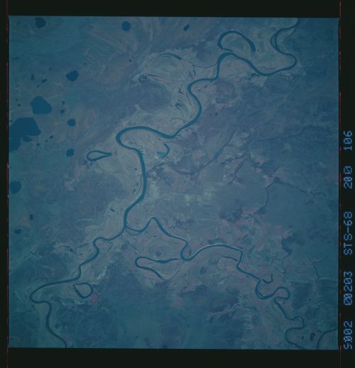
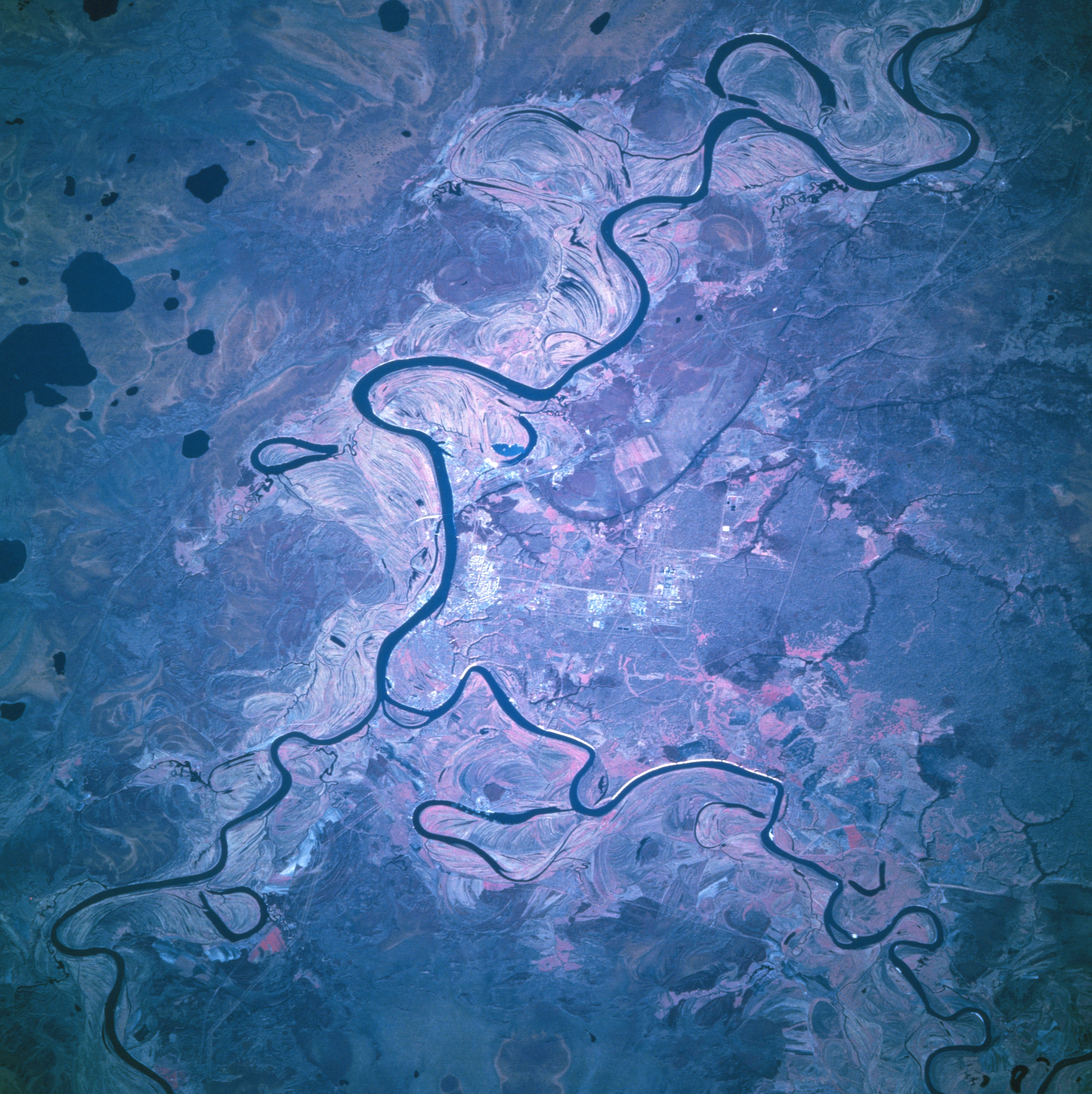
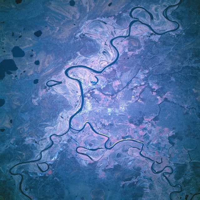
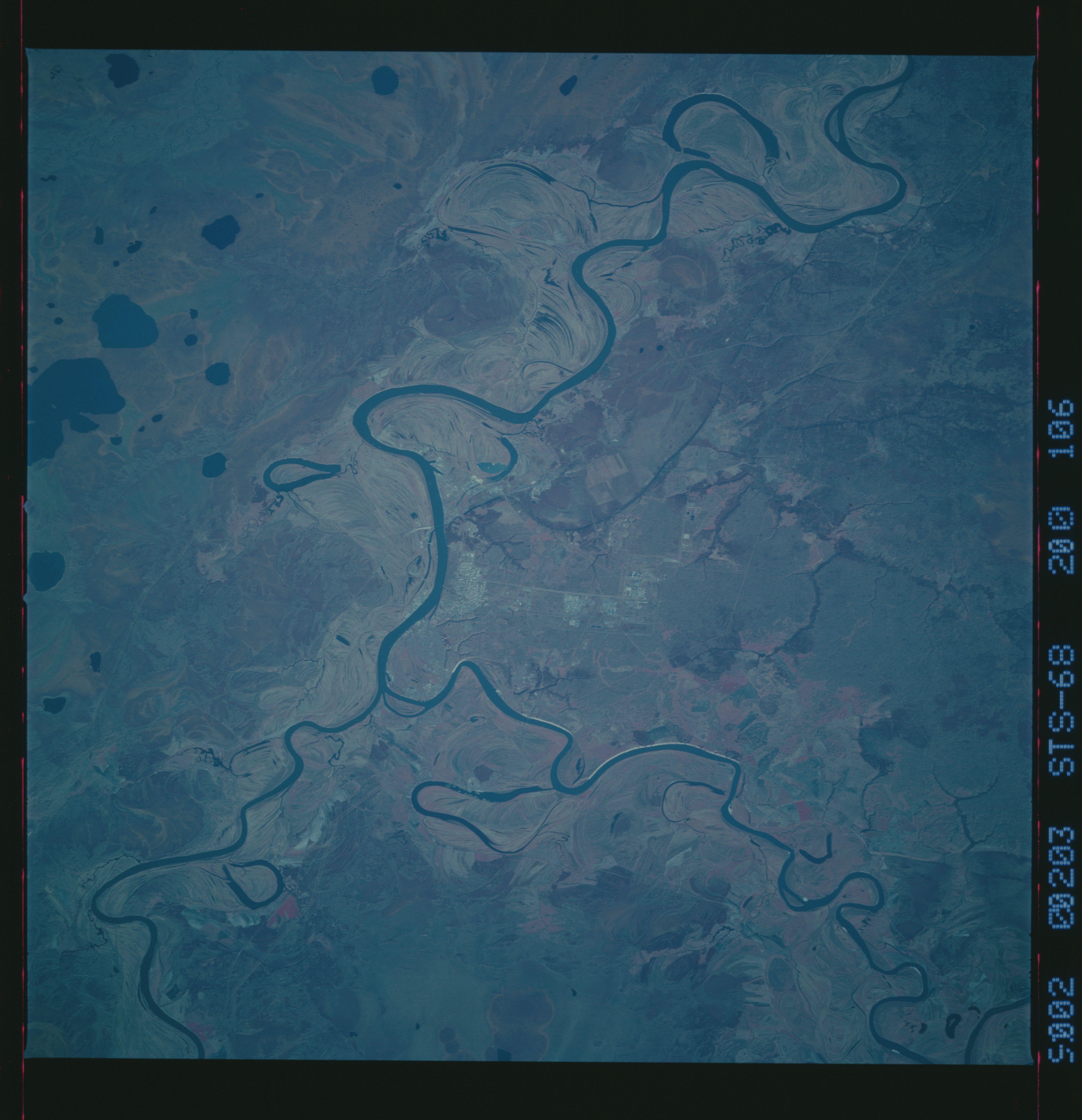
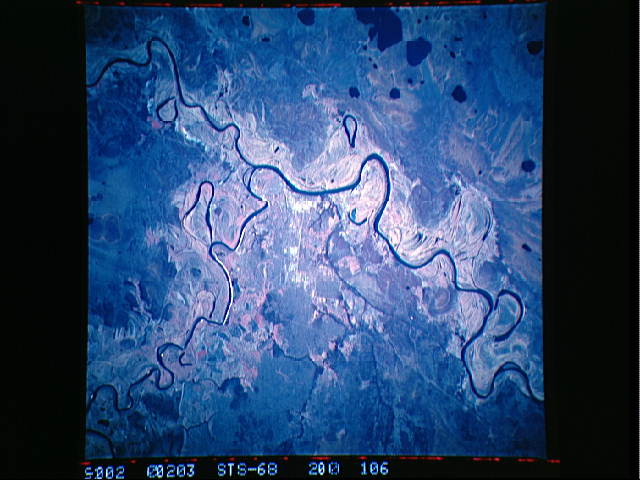
Image Caption: STS068-200-106 Irtysh River, Russia October 1994
The Irtysh River and the Tobol River exhibit dramatic course changes and the rivers merge (slightly below and left of center) near the city of Tobolsk (less than 100000 people). The city is located on the high, eastern bank of the Irtysh River (near center of image). The Irtysh River drains westward (lower right) until it merges with the northerly flowing Tobol River (lower left). After the two rivers merge, the Irtysh River makes a ninety-degree turn to the north. Due to the very flat landscape that characterizes the vast West Siberian Plain, meander scars are pronounced and extensive. Several oxbow lakes (roughly shaped like horseshoes) show the location of former river channels. The dark, mainly oval-shaped features (upper left quadrant) are shallow lakes. The inherent infrared quality of the image (green vegetation is portrayed as shades of red) helps to identify pinkish-looking areas, mainly in the floodplains, where vegetative cover can be discriminated.
The Irtysh River and the Tobol River exhibit dramatic course changes and the rivers merge (slightly below and left of center) near the city of Tobolsk (less than 100000 people). The city is located on the high, eastern bank of the Irtysh River (near center of image). The Irtysh River drains westward (lower right) until it merges with the northerly flowing Tobol River (lower left). After the two rivers merge, the Irtysh River makes a ninety-degree turn to the north. Due to the very flat landscape that characterizes the vast West Siberian Plain, meander scars are pronounced and extensive. Several oxbow lakes (roughly shaped like horseshoes) show the location of former river channels. The dark, mainly oval-shaped features (upper left quadrant) are shallow lakes. The inherent infrared quality of the image (green vegetation is portrayed as shades of red) helps to identify pinkish-looking areas, mainly in the floodplains, where vegetative cover can be discriminated.
