STS068-174-170
| NASA Photo ID | STS068-174-170 |
| Focal Length | 250mm |
| Date taken | 1994.10.06 |
| Time taken | 18:45:02 GMT |

Cloud masks available for this image:
Spacecraft nadir point: 33.7° N, 94.3° W
Photo center point: 33.0° N, 96.0° W
Photo center point by machine learning:
Photo center point: 33.0° N, 96.0° W
Photo center point by machine learning:
Nadir to Photo Center: West
Spacecraft Altitude: 116 nautical miles (215km)
Country or Geographic Name: | USA-TEXAS |
Features: | GREENVILLE, L TAWAKONI |
| Features Found Using Machine Learning: | |
Cloud Cover Percentage: | 5 (1-10)% |
Sun Elevation Angle: | 50° |
Sun Azimuth: | 196° |
Camera: | Linhof |
Focal Length: | 250mm |
Camera Tilt: | 44 degrees |
Format: | 5048: Kodak, natural color positive, Lumiere 100x/5048, ASA 100x, standard base |
Film Exposure: | Normal |
| Additional Information | |
| Width | Height | Annotated | Cropped | Purpose | Links |
|---|---|---|---|---|---|
| 5184 pixels | 4096 pixels | No | No | Earth From Space collection | Download Image |
| 640 pixels | 505 pixels | No | No | Earth From Space collection | Download Image |
| 640 pixels | 480 pixels | No | No | ISD 1 | Download Image |
Download Packaged File
Download a Google Earth KML for this Image
View photo footprint information
Download a GeoTIFF for this photo
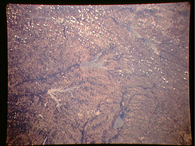
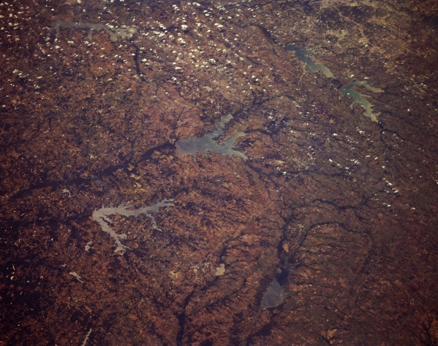
Image Caption: STS068-174-170 Northeast Texas, U.S.A. October 1994
Discernible in this oblique, southwest-looking photograph of northeast Texas are three watersheds--the Trinity River Basin with three large reservoirs [Cedar Creek Reservoir, Lake Ray Hubbard with Interstate Highway 30 crossing its southern end, and Lake Lavon (top right of photograph)]; the Sabine River System with Lake Tawakoni and Lake Folk Reservoir (center of photograph); and the much larger Red River Watershed with dark, east-flowing wooded stream channels, including Lake Cooper, a newly created reservoir, and the South Sulphur River. Visible are part of urban Dallas (upper right corner) and widely scattered cumulus clouds.
Discernible in this oblique, southwest-looking photograph of northeast Texas are three watersheds--the Trinity River Basin with three large reservoirs [Cedar Creek Reservoir, Lake Ray Hubbard with Interstate Highway 30 crossing its southern end, and Lake Lavon (top right of photograph)]; the Sabine River System with Lake Tawakoni and Lake Folk Reservoir (center of photograph); and the much larger Red River Watershed with dark, east-flowing wooded stream channels, including Lake Cooper, a newly created reservoir, and the South Sulphur River. Visible are part of urban Dallas (upper right corner) and widely scattered cumulus clouds.
