STS068-164-124
| NASA Photo ID | STS068-164-124 |
| Focal Length | 250mm |
| Date taken | 1994.10.02 |
| Time taken | 18:29:56 GMT |

Cloud masks available for this image:
Spacecraft nadir point: 45.8° N, 83.3° W
Photo center point: 45.0° N, 85.0° W
Photo center point by machine learning:
Photo center point: 45.0° N, 85.0° W
Photo center point by machine learning:
Nadir to Photo Center: West
Spacecraft Altitude: 118 nautical miles (219km)
Country or Geographic Name: | USA-MICHIGAN |
Features: | GRAND TRAVERSE B, AGRICULTURE, L |
| Features Found Using Machine Learning: | |
Cloud Cover Percentage: | 5 (1-10)% |
Sun Elevation Angle: | 38° |
Sun Azimuth: | 202° |
Camera: | Linhof |
Focal Length: | 250mm |
Camera Tilt: | 44 degrees |
Format: | 5046: Kodak, natural color positive, Lumiere 100/5046, ASA 100, standard base |
Film Exposure: | Normal |
| Additional Information | |
| Width | Height | Annotated | Cropped | Purpose | Links |
|---|---|---|---|---|---|
| 5120 pixels | 4096 pixels | No | No | Earth From Space collection | Download Image |
| 640 pixels | 512 pixels | No | No | Earth From Space collection | Download Image |
| 640 pixels | 480 pixels | No | No | ISD 1 | Download Image |
Download Packaged File
Download a Google Earth KML for this Image
View photo footprint information
Download a GeoTIFF for this photo
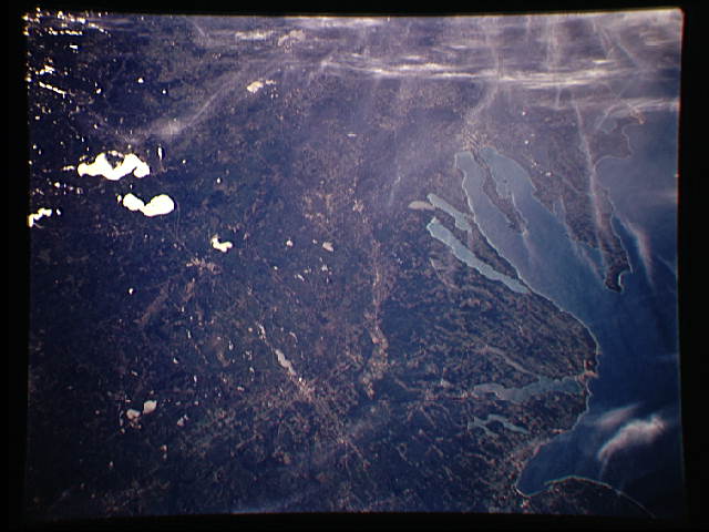
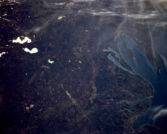
Image Caption: STS068-164-124 Grand Traverse Bay, Michigan, U.S.A October 1994
Featured in this southwest-looking, low-oblique photograph are the northwest forest and agricultural lands adjacent to Grand Traverse Bay (bottom right). An arm of Lake Michigan, the bay, 32 miles (52 kilometers) long and up to 10 miles (16 kilometers) wide, is known for fishing and boating in this popular year-round vacation and resort area. The sandy soils near the shores of Lake Michigan are excellent for fruit-growing, especially cherries. Many lakes are scattered throughout the area--Houghton Lake, the state's largest inland lake, and Higgins Lake to its north (upper left); West and East Twin Lakes to the northeast (lower left); Walloon Lake and larger Charlevoix Lake south of Little Traverse Bay (near bottom right); and elongated Torch Lake and smaller Elk Lake just east of the Grand Traverse Bay shore, at the south end of which is Traverse City (barely discernible).
Featured in this southwest-looking, low-oblique photograph are the northwest forest and agricultural lands adjacent to Grand Traverse Bay (bottom right). An arm of Lake Michigan, the bay, 32 miles (52 kilometers) long and up to 10 miles (16 kilometers) wide, is known for fishing and boating in this popular year-round vacation and resort area. The sandy soils near the shores of Lake Michigan are excellent for fruit-growing, especially cherries. Many lakes are scattered throughout the area--Houghton Lake, the state's largest inland lake, and Higgins Lake to its north (upper left); West and East Twin Lakes to the northeast (lower left); Walloon Lake and larger Charlevoix Lake south of Little Traverse Bay (near bottom right); and elongated Torch Lake and smaller Elk Lake just east of the Grand Traverse Bay shore, at the south end of which is Traverse City (barely discernible).
