STS068-158-C
| NASA Photo ID | STS068-158-C |
| Focal Length | 90mm |
| Date taken | 1994.__.__ |
| Time taken | GMT |

Cloud masks available for this image:
Spacecraft nadir point:
Photo center point: 35.0° N, 79.5° E
Photo center point by machine learning:
Photo center point: 35.0° N, 79.5° E
Photo center point by machine learning:
Nadir to Photo Center:
Spacecraft Altitude: nautical miles (0km)
Country or Geographic Name: | CHINA |
Features: | KUNLUN MTS., TIBET PLAT. |
| Features Found Using Machine Learning: | |
Cloud Cover Percentage: | 5 (1-10)% |
Sun Elevation Angle: | ° |
Sun Azimuth: | ° |
Camera: | Linhof |
Focal Length: | 90mm |
Camera Tilt: | High Oblique |
Format: | 5046: Kodak, natural color positive, Lumiere 100/5046, ASA 100, standard base |
Film Exposure: | Normal |
| Additional Information | |
| Width | Height | Annotated | Cropped | Purpose | Links |
|---|---|---|---|---|---|
| 5611 pixels | 4489 pixels | No | No | Earth From Space collection | Download Image |
| 639 pixels | 512 pixels | No | No | Earth From Space collection | Download Image |
| 640 pixels | 480 pixels | No | No | ISD 1 | Download Image |
Download Packaged File
Download a Google Earth KML for this Image
View photo footprint information
Download a GeoTIFF for this photo
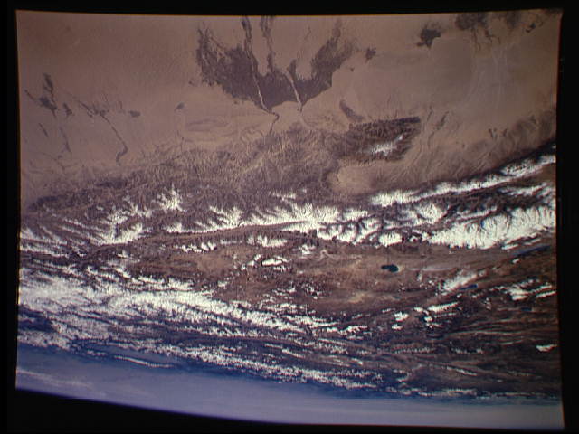
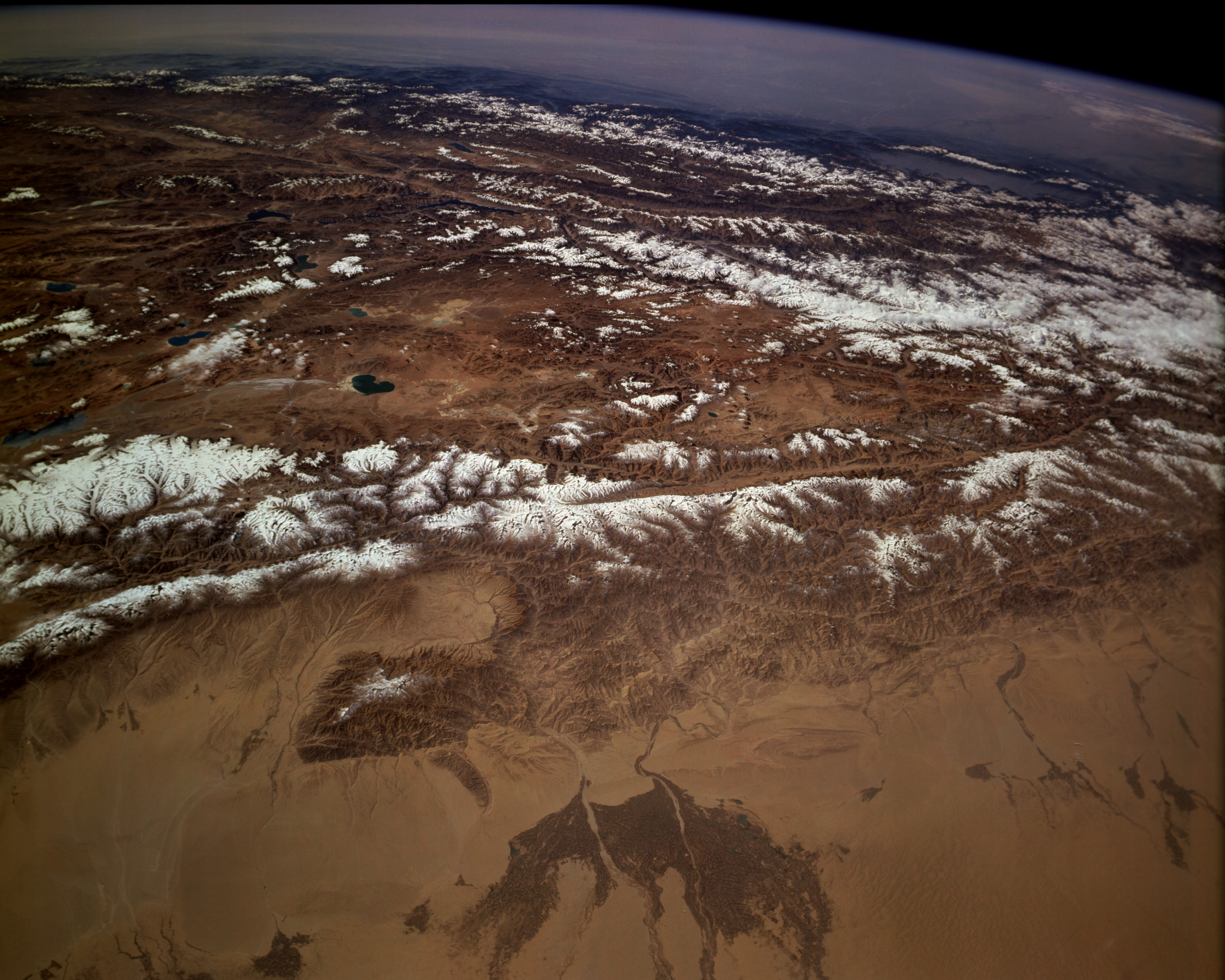
Image Caption: STS068-158-00C Takla Makan Desert, Kunlun Mountains, and Tibetan Plateau, China October 1994
Viewing north to south, three major physiographic features are clearly seen in this panorama of western China--the southern fringe of the Takla Makan Desert, the high Kunlun Mountains, and the Tibetan Plateau. Most of the area shown in this photograph receives less than 10 inches (25 centimeters) of precipitation annually; most surface water that flows through the valleys and into the desert comes from snowmelt in the high mountains. Several major north-flowing watercourses (darker areas) that allow irrigated agriculture extend into the otherwise nonvegetated southern fringe of the Takla Makan Desert. The city of Hotan is not discernible at this scale; however, it lies between two stream channels within the darker delta. The snowcapped, generally east-west trending Kunlun Mountains, with most peaks exceeding 20 000 feet (7000 meters), are a major physical barrier between the Takla Makan Desert and the extensive, elevated, arid Tibetan Plateau. Basin elevations within the plateau average approximately 17 000 feet (5180 meters). The lakes on the plateau result from snowmelt in the surrounding mountains. This mountainous plateau, with most major fault structures having an east-west orientation, was formed and continues to be modified by the collision of the Australian-Indian Plate and the Eurasian Plate.
Viewing north to south, three major physiographic features are clearly seen in this panorama of western China--the southern fringe of the Takla Makan Desert, the high Kunlun Mountains, and the Tibetan Plateau. Most of the area shown in this photograph receives less than 10 inches (25 centimeters) of precipitation annually; most surface water that flows through the valleys and into the desert comes from snowmelt in the high mountains. Several major north-flowing watercourses (darker areas) that allow irrigated agriculture extend into the otherwise nonvegetated southern fringe of the Takla Makan Desert. The city of Hotan is not discernible at this scale; however, it lies between two stream channels within the darker delta. The snowcapped, generally east-west trending Kunlun Mountains, with most peaks exceeding 20 000 feet (7000 meters), are a major physical barrier between the Takla Makan Desert and the extensive, elevated, arid Tibetan Plateau. Basin elevations within the plateau average approximately 17 000 feet (5180 meters). The lakes on the plateau result from snowmelt in the surrounding mountains. This mountainous plateau, with most major fault structures having an east-west orientation, was formed and continues to be modified by the collision of the Australian-Indian Plate and the Eurasian Plate.
