STS067-725A-37

| NASA Photo ID | STS067-725A-37 |
| Focal Length | 250mm |
| Date taken | 1995.03.12 |
| Time taken | 02:07:36 GMT |

Cloud masks available for this image:
Spacecraft nadir point: 25.8° S, 114.7° E
Photo center point: 26.0° S, 114.0° E
Photo center point by machine learning:
Photo center point: 26.0° S, 114.0° E
Photo center point by machine learning:
Nadir to Photo Center: West
Spacecraft Altitude: 192 nautical miles (356km)
Country or Geographic Name: | AUSTRALIA-WA |
Features: | DISAPPOINTMENT REACH, IS. |
| Features Found Using Machine Learning: | |
Cloud Cover Percentage: | 0 (no clouds present) |
Sun Elevation Angle: | 49° |
Sun Azimuth: | 63° |
Camera: | Hasselblad |
Focal Length: | 250mm |
Camera Tilt: | 13 degrees |
Format: | 5046: Kodak, natural color positive, Lumiere 100/5046, ASA 100, standard base |
Film Exposure: | Normal |
| Additional Information | |
| Width | Height | Annotated | Cropped | Purpose | Links |
|---|---|---|---|---|---|
| 5700 pixels | 5900 pixels | No | No | Download Image | |
| 500 pixels | 518 pixels | No | No | Download Image | |
| 640 pixels | 480 pixels | No | No | Download Image |
Download Packaged File
Download a Google Earth KML for this Image
View photo footprint information
Download a GeoTIFF for this photo
Image Caption: is a much closer, more nearly-vertical view of
disappointment Reach and surroundings. Ripple-like patterns extending
at right angles to the tidal flow can be discerned on shoals. Relict
sand dune patterns, crests unvegetated, are evident on the western
side of the estuary. Red mud brought down the Mooramel River on the
east side of the esturary does extend into the shallow water of the
intertidal lagoons. Most of the light-colored water along the coast,
though, represents shoals of lime sediment. Patterns of sediment
distribution by tides, waves, streams, and wind combine to create a
complex and colorful scene.
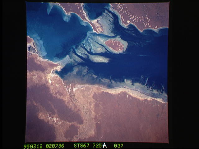
A nearly vertical view of Disappointment Reach and surroundings. Ripple-like patterns extending at right angles to the tidal flow can be discerned on shoals. Relict sand dune patterns, crests unvegetated, are evident on the western side of the estuary. Red mud brought down the Mooramel River on the east side of the estuary does extend into the shallow water of the inter-tidal lagoons. Most of the light-colored water along the coast, represents shoals of lime sediment. Patterns of sediment distribution by tides, waves, streams, and wind combine to create a complex and colorful scene.
disappointment Reach and surroundings. Ripple-like patterns extending
at right angles to the tidal flow can be discerned on shoals. Relict
sand dune patterns, crests unvegetated, are evident on the western
side of the estuary. Red mud brought down the Mooramel River on the
east side of the esturary does extend into the shallow water of the
intertidal lagoons. Most of the light-colored water along the coast,
though, represents shoals of lime sediment. Patterns of sediment
distribution by tides, waves, streams, and wind combine to create a
complex and colorful scene.
A nearly vertical view of Disappointment Reach and surroundings. Ripple-like patterns extending at right angles to the tidal flow can be discerned on shoals. Relict sand dune patterns, crests unvegetated, are evident on the western side of the estuary. Red mud brought down the Mooramel River on the east side of the estuary does extend into the shallow water of the inter-tidal lagoons. Most of the light-colored water along the coast, represents shoals of lime sediment. Patterns of sediment distribution by tides, waves, streams, and wind combine to create a complex and colorful scene.
