STS066-85-76
| NASA Photo ID | STS066-85-76 |
| Focal Length | 250mm |
| Date taken | 1994.11.08 |
| Time taken | 04:09:54 GMT |
Resolutions offered for this image:
4078 x 4096 pixels 637 x 640 pixels 5700 x 5900 pixels 500 x 518 pixels 640 x 480 pixels 525 x 518 pixels
4078 x 4096 pixels 637 x 640 pixels 5700 x 5900 pixels 500 x 518 pixels 640 x 480 pixels 525 x 518 pixels


Cloud masks available for this image:
Spacecraft nadir point: 25.7° N, 85.7° E
Photo center point: 25.5° N, 86.5° E
Photo center point by machine learning:
Photo center point: 25.5° N, 86.5° E
Photo center point by machine learning:
Nadir to Photo Center: East
Spacecraft Altitude: 160 nautical miles (296km)
Country or Geographic Name: | INDIA |
Features: | GANGES R, JAMALPUR AREA |
| Features Found Using Machine Learning: | |
Cloud Cover Percentage: | 0 (no clouds present) |
Sun Elevation Angle: | 40° |
Sun Azimuth: | 144° |
Camera: | Hasselblad |
Focal Length: | 250mm |
Camera Tilt: | 17 degrees |
Format: | 2443: Kodak Aerochrome 2443, color IR, thin base, EA-5 process thru June 1999, E-6 process afterward |
Film Exposure: | Normal |
| Additional Information | |
| Width | Height | Annotated | Cropped | Purpose | Links |
|---|---|---|---|---|---|
| 4078 pixels | 4096 pixels | No | No | Earth From Space collection | Download Image |
| 637 pixels | 640 pixels | No | No | Earth From Space collection | Download Image |
| 5700 pixels | 5900 pixels | No | No | Download Image | |
| 500 pixels | 518 pixels | No | No | Download Image | |
| 640 pixels | 480 pixels | No | No | Download Image | |
| 525 pixels | 518 pixels | Download Image |
Download Packaged File
Download a Google Earth KML for this Image
View photo footprint information
Download a GeoTIFF for this photo
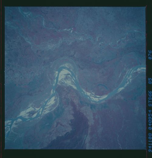
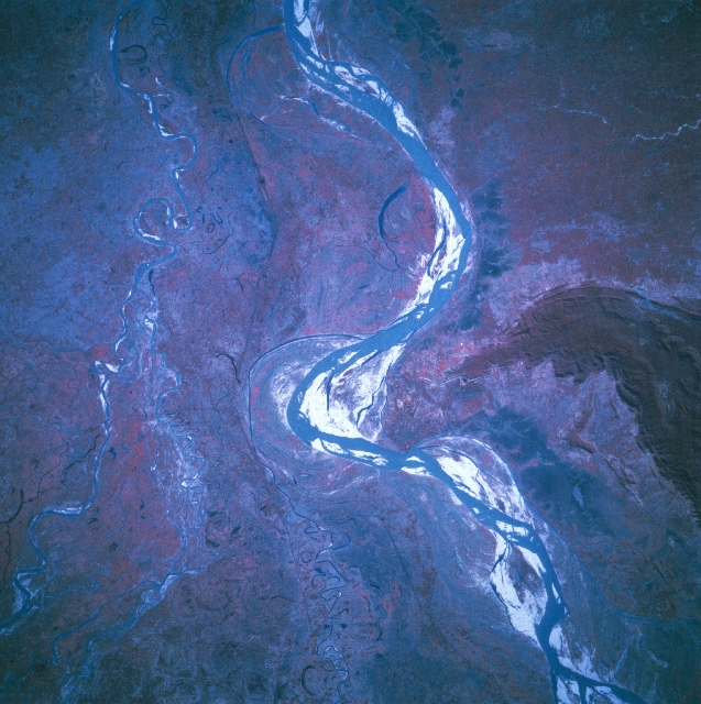
Image Caption: STS066-085-076 Ganges River, India November 1994
The eastward flowing Ganges River (upper left to bottom center) makes a dramatic but brief course change around the northern end of hills (center of image) that protrude northward. Two small Indian towns, Monghyr and Jamalpur, are located along the western edge of the hilly protrusion. The highly reflective (white-looking) surfaces within the broad floodplain of the Ganges River are sandbars. Note that some of the sandbars have green vegetation (represented by shades of red) growing on the sandy, alluvial soils. The reddish colors (green vegetation) of this color infrared image maps vegetation density differences throughout the scene. The hills, for example, (left center) with their deep reds shows a dense forest cover, while the lighter pinks map agricultural lands or areas of less dense vegetation. The color infrared film also helps to identify numerous scars on the landscape that are attributable to course changes in the Ganges River. The dark linear feature that skirts (runs vertically, top to bottom) the northern border of the Ganges floodplain is a railroad right of way that has been built on a levee. The meandering Ghugri River, a tributary of the Ganges, is visible near the right margin of the image.
The eastward flowing Ganges River (upper left to bottom center) makes a dramatic but brief course change around the northern end of hills (center of image) that protrude northward. Two small Indian towns, Monghyr and Jamalpur, are located along the western edge of the hilly protrusion. The highly reflective (white-looking) surfaces within the broad floodplain of the Ganges River are sandbars. Note that some of the sandbars have green vegetation (represented by shades of red) growing on the sandy, alluvial soils. The reddish colors (green vegetation) of this color infrared image maps vegetation density differences throughout the scene. The hills, for example, (left center) with their deep reds shows a dense forest cover, while the lighter pinks map agricultural lands or areas of less dense vegetation. The color infrared film also helps to identify numerous scars on the landscape that are attributable to course changes in the Ganges River. The dark linear feature that skirts (runs vertically, top to bottom) the northern border of the Ganges floodplain is a railroad right of way that has been built on a levee. The meandering Ghugri River, a tributary of the Ganges, is visible near the right margin of the image.
