STS066-85-18

| NASA Photo ID | STS066-85-18 |
| Focal Length | 250mm |
| Date taken | 1994.11.07 |
| Time taken | 21:58:20 GMT |
Resolutions offered for this image:
4068 x 4068 pixels 639 x 639 pixels 5700 x 5900 pixels 500 x 518 pixels 640 x 480 pixels 521 x 520 pixels
4068 x 4068 pixels 639 x 639 pixels 5700 x 5900 pixels 500 x 518 pixels 640 x 480 pixels 521 x 520 pixels


Cloud masks available for this image:
Spacecraft nadir point: 6.7° S, 157.6° E
Photo center point: 7.0° S, 157.0° E
Photo center point by machine learning:
Photo center point: 7.0° S, 157.0° E
Photo center point by machine learning:
Nadir to Photo Center: Southwest
Spacecraft Altitude: 159 nautical miles (294km)
Country or Geographic Name: | SOLOMON ISLANDS |
Features: | CHOISEUL ISLAND |
| Features Found Using Machine Learning: | |
Cloud Cover Percentage: | 5 (1-10)% |
Sun Elevation Angle: | 41° |
Sun Azimuth: | 106° |
Camera: | Hasselblad |
Focal Length: | 250mm |
Camera Tilt: | 14 degrees |
Format: | 2443: Kodak Aerochrome 2443, color IR, thin base, EA-5 process thru June 1999, E-6 process afterward |
Film Exposure: | Normal |
| Additional Information | |
| Width | Height | Annotated | Cropped | Purpose | Links |
|---|---|---|---|---|---|
| 4068 pixels | 4068 pixels | No | No | Earth From Space collection | Download Image |
| 639 pixels | 639 pixels | No | No | Earth From Space collection | Download Image |
| 5700 pixels | 5900 pixels | No | No | Download Image | |
| 500 pixels | 518 pixels | No | No | Download Image | |
| 640 pixels | 480 pixels | No | No | Download Image | |
| 521 pixels | 520 pixels | Download Image |
Download Packaged File
Download a Google Earth KML for this Image
View photo footprint information
Download a GeoTIFF for this photo
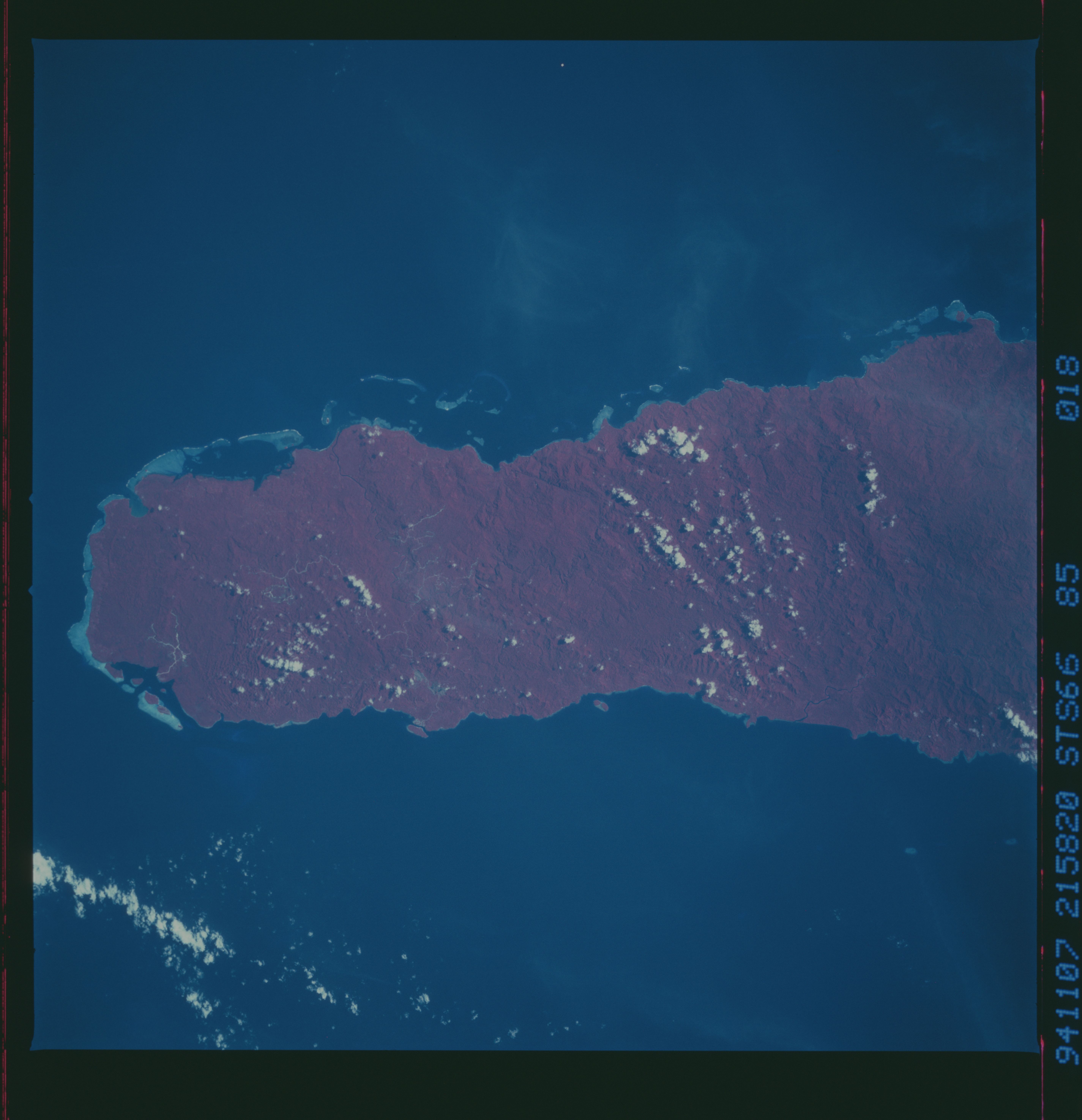
Image Caption: STS066-085-018 Choiseul Island, Solomon Islands November 1994
Choiseul Island is one of several volcanic islands that make up the island nation of the Solomon Islands in the southwest Pacific Ocean. The axis of this double chain of islands is oriented northwest to southeast. As viewed in this color infrared image, (dense green rainforest are presented in shades of red), Choiseul Island is characterized by thickly forested mountains. A few roads (thin, light-colored lines) can be traced through parts of the dense jungle near the northwest end of the island. Several small islands and coral reefs (lighter-colored areas) are visible along the northwest tip of the island and along the northeast coast.
Choiseul Island is one of several volcanic islands that make up the island nation of the Solomon Islands in the southwest Pacific Ocean. The axis of this double chain of islands is oriented northwest to southeast. As viewed in this color infrared image, (dense green rainforest are presented in shades of red), Choiseul Island is characterized by thickly forested mountains. A few roads (thin, light-colored lines) can be traced through parts of the dense jungle near the northwest end of the island. Several small islands and coral reefs (lighter-colored areas) are visible along the northwest tip of the island and along the northeast coast.
