STS066-208-25
| NASA Photo ID | STS066-208-25 |
| Focal Length | mm |
| Date taken | 1994.11.__ |
| Time taken | GMT |
Resolutions offered for this image:
3460 x 2249 pixels 639 x 415 pixels 1780 x 2717 pixels 1631 x 1123 pixels
3460 x 2249 pixels 639 x 415 pixels 1780 x 2717 pixels 1631 x 1123 pixels
Cloud masks available for this image:
Spacecraft nadir point:
Photo center point: 28.0° N, 87.0° E
Photo center point by machine learning:
Photo center point: 28.0° N, 87.0° E
Photo center point by machine learning:
Nadir to Photo Center:
Spacecraft Altitude: nautical miles (0km)
Country or Geographic Name: | NEPAL |
Features: | MOUNT EVEREST |
| Features Found Using Machine Learning: | |
Cloud Cover Percentage: | 0 (no clouds present) |
Sun Elevation Angle: | ° |
Sun Azimuth: | ° |
Camera: | Nikon 35mm film camera |
Focal Length: | mm |
Camera Tilt: | Low Oblique |
Format: | 5096: Kodak, color negative, Gold Super 200, ASA 200, standard base |
Film Exposure: | |
| Additional Information | |
| Width | Height | Annotated | Cropped | Purpose | Links |
|---|---|---|---|---|---|
| 3460 pixels | 2249 pixels | No | No | Earth From Space collection | Download Image |
| 639 pixels | 415 pixels | No | No | Earth From Space collection | Download Image |
| 1780 pixels | 2717 pixels | Download Image | |||
| 1631 pixels | 1123 pixels | Download Image |
Download Packaged File
Download a Google Earth KML for this Image
View photo footprint information
Download a GeoTIFF for this photo
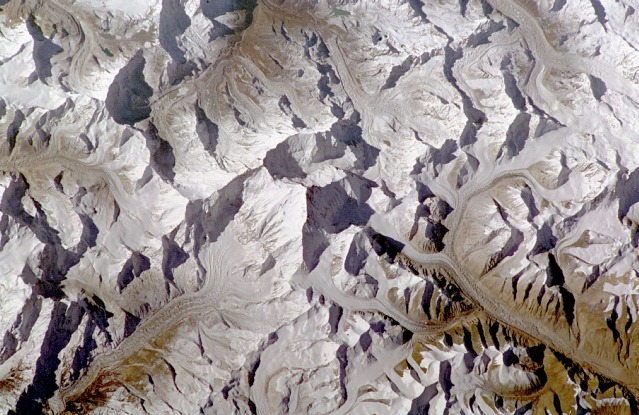
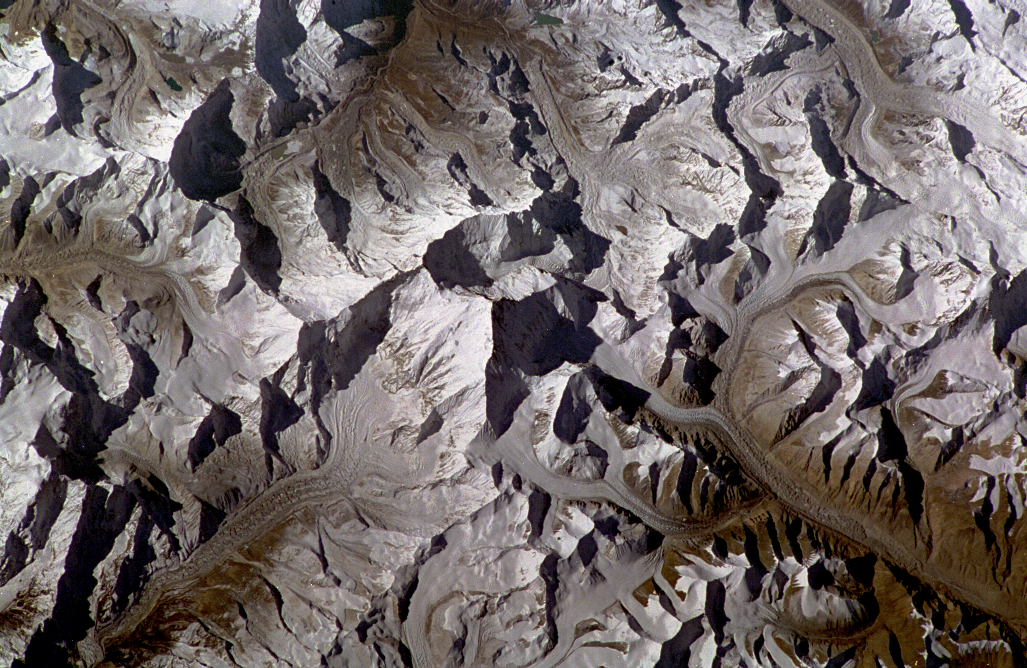
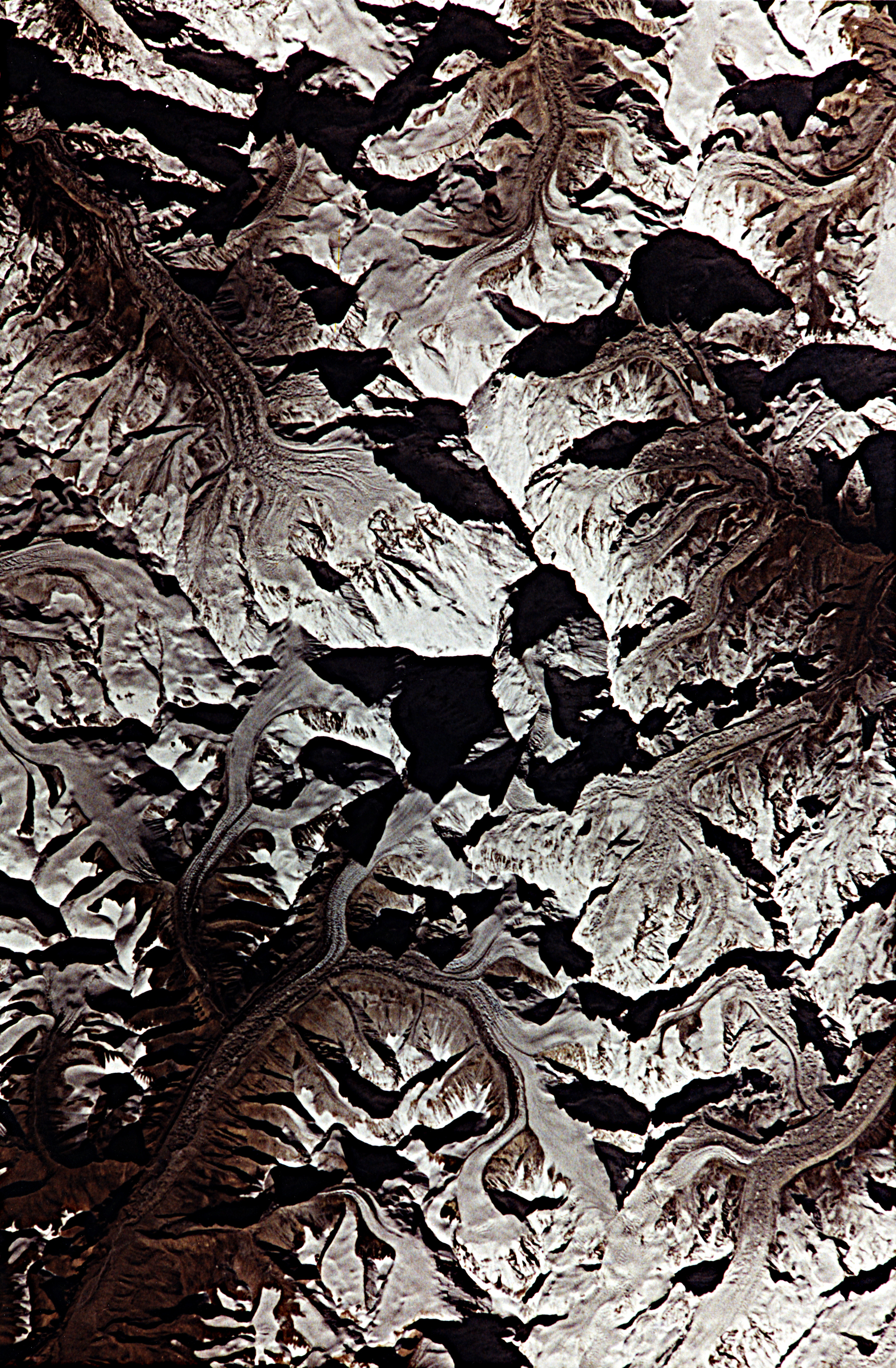
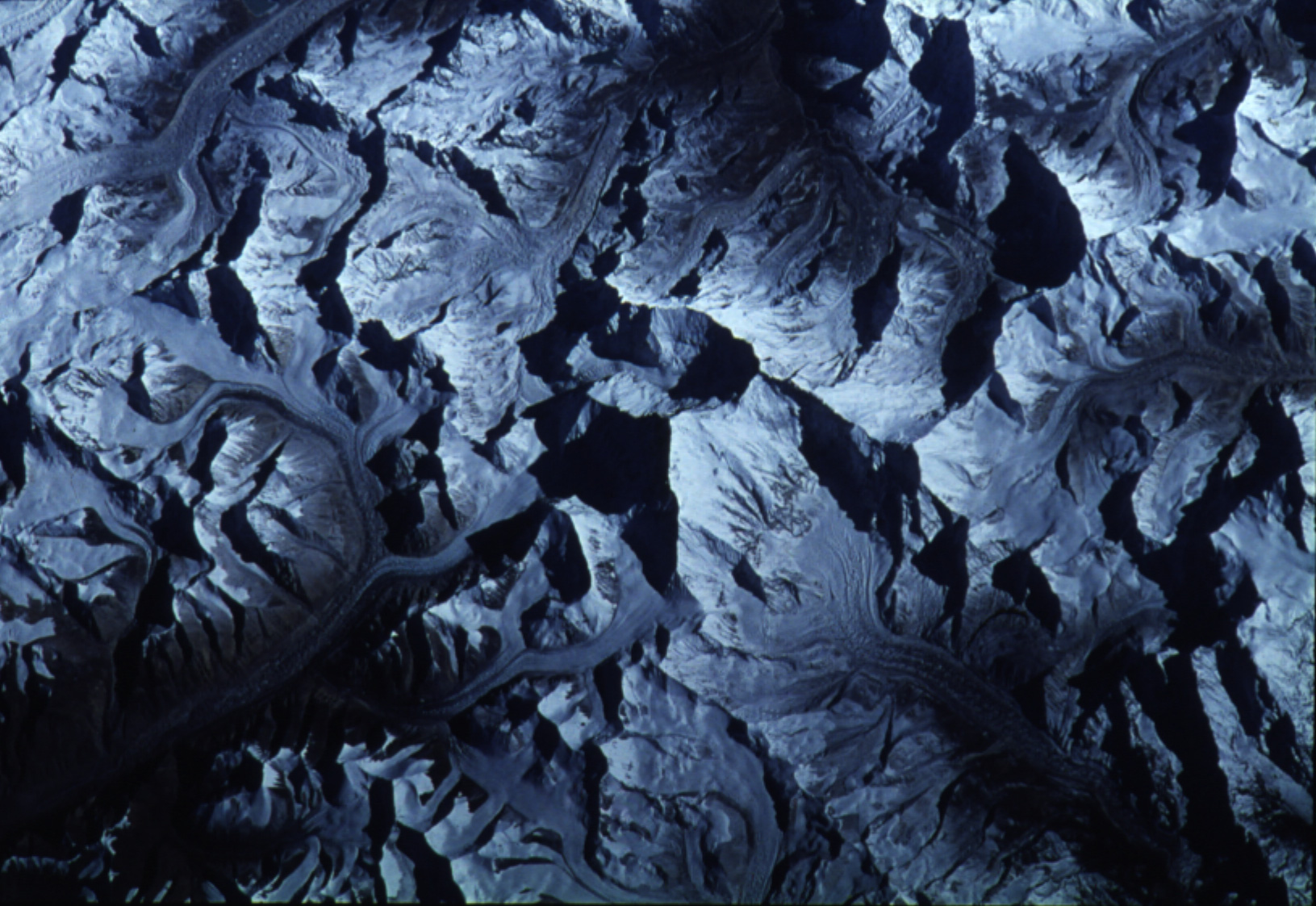
Image Caption: STS066-208-25 Mount Everest, Tibet and Nepal November 1994
This spectacular, south-looking, low-oblique photograph shows the highest mountain in the world, Mount Everest (center of the photograph). The photograph was taken during the morning, and shadows are west of the high features; Mount Everest casts the largest shadow. Located on the border between Tibet and Nepal in the central Himalaya Mountains, Everest soars 29 028 feet (8854 meters) above sea level. Mount Everest began to form millions of years ago, as did the whole Himalayan Range, when the India subcontinent collided with Asia. Deep layers of rock were folded and refolded, creating Everest and the other great, rugged peaks of the Himalayas. Further modeling by the erosive action of wind, rain, snow, and ice--especially in the form of glaciers--honed Everest to its present dreadful contours. The mountain as viewed in this photograph resembles a U-shape with the opening at its northwest end and the summit at the north end. The area known as the South Col appears southeast of Everest. The peaks of Lhotse and Nuptse emerge south and southwest of South Col, respectively. Several large, impressive glaciers radiating from the mountaintop still occupy the rugged valleys. The Khumbu Glacier, which flows west-northwest and then turns to the southwest upon reaching the base of the mountain, is the route taken by many mountain climbers. The photograph emphasizes the formidable terrain on which many mountain climbers have forfeited their lives seeking the pinnacle. The summit of Mount Everest was finally reached by Sir Edmund Hillary of New Zealand and his Sherpa, Tenzing Norkay of Nepal, on May 28, 1953.
This spectacular, south-looking, low-oblique photograph shows the highest mountain in the world, Mount Everest (center of the photograph). The photograph was taken during the morning, and shadows are west of the high features; Mount Everest casts the largest shadow. Located on the border between Tibet and Nepal in the central Himalaya Mountains, Everest soars 29 028 feet (8854 meters) above sea level. Mount Everest began to form millions of years ago, as did the whole Himalayan Range, when the India subcontinent collided with Asia. Deep layers of rock were folded and refolded, creating Everest and the other great, rugged peaks of the Himalayas. Further modeling by the erosive action of wind, rain, snow, and ice--especially in the form of glaciers--honed Everest to its present dreadful contours. The mountain as viewed in this photograph resembles a U-shape with the opening at its northwest end and the summit at the north end. The area known as the South Col appears southeast of Everest. The peaks of Lhotse and Nuptse emerge south and southwest of South Col, respectively. Several large, impressive glaciers radiating from the mountaintop still occupy the rugged valleys. The Khumbu Glacier, which flows west-northwest and then turns to the southwest upon reaching the base of the mountain, is the route taken by many mountain climbers. The photograph emphasizes the formidable terrain on which many mountain climbers have forfeited their lives seeking the pinnacle. The summit of Mount Everest was finally reached by Sir Edmund Hillary of New Zealand and his Sherpa, Tenzing Norkay of Nepal, on May 28, 1953.
