STS066-158-102
| NASA Photo ID | STS066-158-102 |
| Focal Length | 250mm |
| Date taken | 1994.11.__ |
| Time taken | GMT |

Cloud masks available for this image:
Spacecraft nadir point:
Photo center point: 36.5° N, 88.5° W
Photo center point by machine learning:
Photo center point: 36.5° N, 88.5° W
Photo center point by machine learning:
Nadir to Photo Center:
Spacecraft Altitude: nautical miles (0km)
Country or Geographic Name: | USA-KENTUCKY |
Features: | KENTUCKY LAKE AREA |
| Features Found Using Machine Learning: | |
Cloud Cover Percentage: | 5 (1-10)% |
Sun Elevation Angle: | ° |
Sun Azimuth: | ° |
Camera: | Linhof |
Focal Length: | 250mm |
Camera Tilt: | Low Oblique |
Format: | 5046: Kodak, natural color positive, Lumiere 100/5046, ASA 100, standard base |
Film Exposure: | Normal |
| Additional Information | |
| Width | Height | Annotated | Cropped | Purpose | Links |
|---|---|---|---|---|---|
| 5120 pixels | 4096 pixels | No | No | Earth From Space collection | Download Image |
| 640 pixels | 512 pixels | No | No | Earth From Space collection | Download Image |
| 640 pixels | 480 pixels | No | No | ISD 1 | Download Image |
Download Packaged File
Download a Google Earth KML for this Image
View photo footprint information
Download a GeoTIFF for this photo
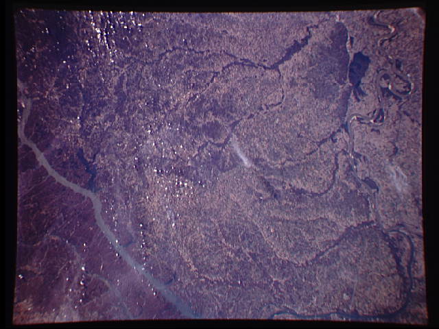
Image Caption: STS066-158-102 Western Kentucky, U.S.A. November 1994
Featured in this photograph of western Kentucky are three bodies of water--from west to east, the meandering Mississippi River with lighter sandbars in its main channel, the Ohio River, and Kentucky Lake. A small section of the Ohio River, which merges with the Mississippi River just beyond the scope of this photograph, is apparent (top left). Long, wide Kentucky Lake appears farthest east. The dendritic drainage pattern shows that most of the land between the Mississippi River and Kentucky Lake drains westward into the Mississippi River.
Featured in this photograph of western Kentucky are three bodies of water--from west to east, the meandering Mississippi River with lighter sandbars in its main channel, the Ohio River, and Kentucky Lake. A small section of the Ohio River, which merges with the Mississippi River just beyond the scope of this photograph, is apparent (top left). Long, wide Kentucky Lake appears farthest east. The dendritic drainage pattern shows that most of the land between the Mississippi River and Kentucky Lake drains westward into the Mississippi River.
