STS066-152-22
| NASA Photo ID | STS066-152-22 |
| Focal Length | 90mm |
| Date taken | 1994.11.06 |
| Time taken | 12:42:21 GMT |
Resolutions offered for this image:
640 x 480 pixels
640 x 480 pixels
Cloud masks available for this image:
Spacecraft nadir point: 25.1° S, 68.8° W
Photo center point: 25.5° S, 67.5° W
Photo center point by machine learning:
Photo center point: 25.5° S, 67.5° W
Photo center point by machine learning:
Nadir to Photo Center: East
Spacecraft Altitude: 160 nautical miles (296km)
Country or Geographic Name: | ARGENTINA |
Features: | ARIZARO SALAR, ANDES MTS |
| Features Found Using Machine Learning: | |
Cloud Cover Percentage: | 0 (no clouds present) |
Sun Elevation Angle: | 39° |
Sun Azimuth: | 91° |
Camera: | Linhof |
Focal Length: | 90mm |
Camera Tilt: | 27 degrees |
Format: | 5046: Kodak, natural color positive, Lumiere 100/5046, ASA 100, standard base |
Film Exposure: | Normal |
| Additional Information | |
| Width | Height | Annotated | Cropped | Purpose | Links |
|---|---|---|---|---|---|
| 640 pixels | 480 pixels | No | No | ISD 1 | Download Image |
Download Packaged File
Download a Google Earth KML for this Image
View photo footprint information
Download a GeoTIFF for this photo
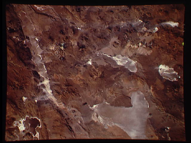
Image Caption: This photograph captures the exotic volcanic terrain of the Altiplano of the Central Andes. Some of the remarkable details include the west-pointing wind streaks, resulting from fine dust being transported across the Andes by the high winds; paleo (old) shorelines along the margins of the salars (or dry lake beds), recording the changes in water levels on the high Altiplano; beautiful alluvial fans emptying onto some of salars; and the hundreds of volcanic land forms which can be mapped and interpreted to help decipher the volcanic history of the region.
