STS066-127-79

| NASA Photo ID | STS066-127-79 |
| Focal Length | 100mm |
| Date taken | 1994.11.08 |
| Time taken | 05:43:51 GMT |
Resolutions offered for this image:
4096 x 4096 pixels 640 x 640 pixels 5700 x 5900 pixels 500 x 518 pixels 640 x 480 pixels 525 x 513 pixels
4096 x 4096 pixels 640 x 640 pixels 5700 x 5900 pixels 500 x 518 pixels 640 x 480 pixels 525 x 513 pixels


Cloud masks available for this image:
Spacecraft nadir point: 36.5° N, 72.3° E
Photo center point: 34.5° N, 74.5° E
Photo center point by machine learning:
Photo center point: 34.5° N, 74.5° E
Photo center point by machine learning:
Nadir to Photo Center: Southeast
Spacecraft Altitude: 160 nautical miles (296km)
Country or Geographic Name: | INDIA |
Features: | HIMALAYAS, PIR PANJAL RA |
| Features Found Using Machine Learning: | |
Cloud Cover Percentage: | 0 (no clouds present) |
Sun Elevation Angle: | 35° |
Sun Azimuth: | 159° |
Camera: | Hasselblad |
Focal Length: | 100mm |
Camera Tilt: | 48 degrees |
Format: | 5046: Kodak, natural color positive, Lumiere 100/5046, ASA 100, standard base |
Film Exposure: | Normal |
| Additional Information | |
| Width | Height | Annotated | Cropped | Purpose | Links |
|---|---|---|---|---|---|
| 4096 pixels | 4096 pixels | No | No | Earth From Space collection | Download Image |
| 640 pixels | 640 pixels | No | No | Earth From Space collection | Download Image |
| 5700 pixels | 5900 pixels | No | No | Download Image | |
| 500 pixels | 518 pixels | No | No | Download Image | |
| 640 pixels | 480 pixels | No | No | Download Image | |
| 525 pixels | 513 pixels | Download Image |
Download Packaged File
Download a Google Earth KML for this Image
View photo footprint information
Download a GeoTIFF for this photo
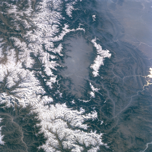
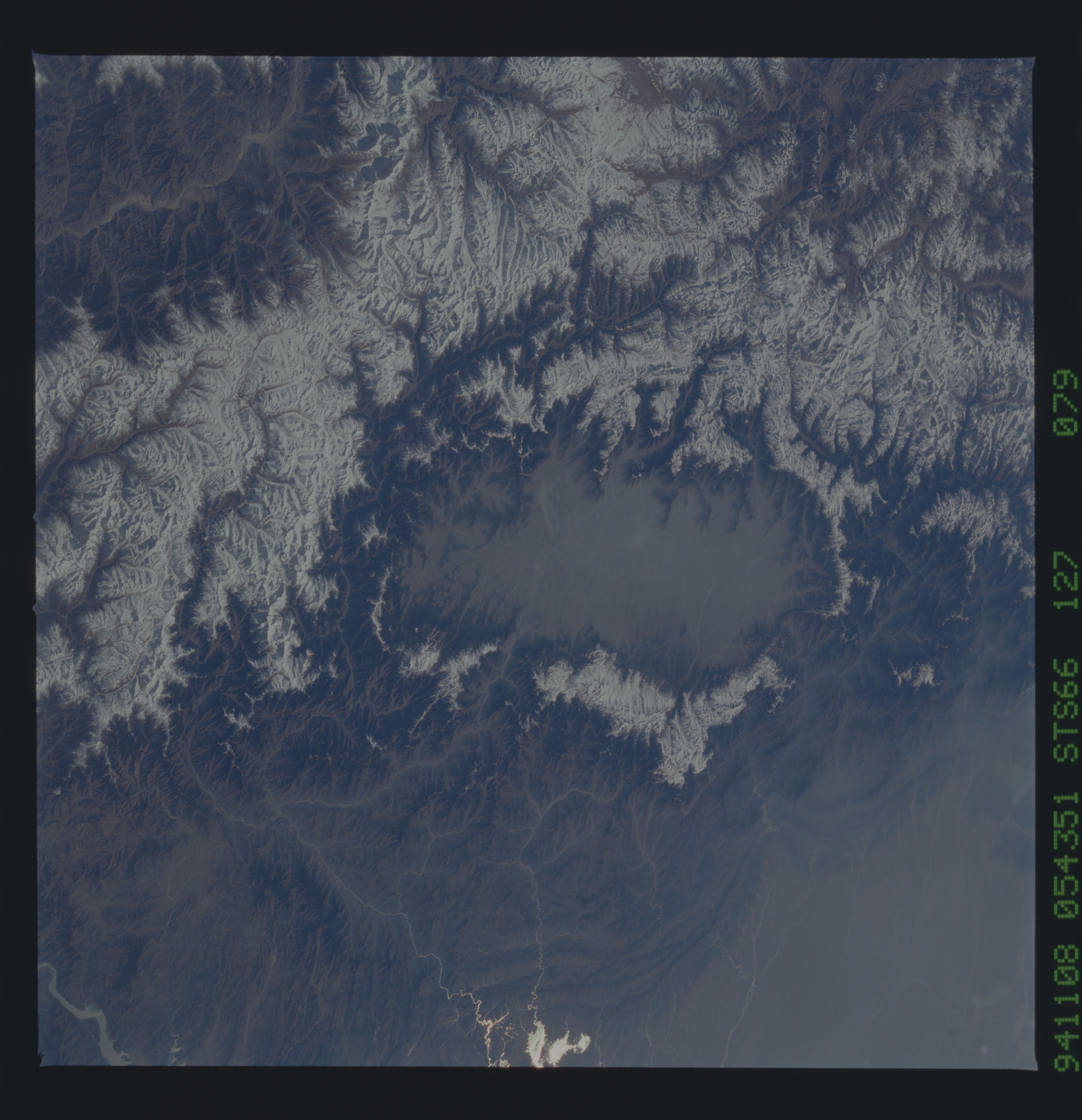
Image Caption: STS066-127-079 Vale of Kashmir, India November 1994
Located in the Indian state of Jammu and Kashmir, the hazy valley in the center of the image is the Vale of Kashmir. The Vale of Kashmir is surrounded by rugged mountains, many which exceed 17000 feet (5180 meters) in elevation. The valley floor averages about 5400 feet (1645 meters). These snow-covered mountains are part of the western extension of the Himalaya Mountains. The Jhelum River (thin, light-colored linear feature), a westerly draining tributary of the Indus River, can be traced through a deep gorge in the mountains along the northwest side of the Vale of Kashmir. Several other streams are visible as they drain westward into the Indus River Basin. A small section of the Indus River is also visible in the lower left corner of the image where the river has carved a large valley through the western end of the Himalaya Mountains.
Located in the Indian state of Jammu and Kashmir, the hazy valley in the center of the image is the Vale of Kashmir. The Vale of Kashmir is surrounded by rugged mountains, many which exceed 17000 feet (5180 meters) in elevation. The valley floor averages about 5400 feet (1645 meters). These snow-covered mountains are part of the western extension of the Himalaya Mountains. The Jhelum River (thin, light-colored linear feature), a westerly draining tributary of the Indus River, can be traced through a deep gorge in the mountains along the northwest side of the Vale of Kashmir. Several other streams are visible as they drain westward into the Indus River Basin. A small section of the Indus River is also visible in the lower left corner of the image where the river has carved a large valley through the western end of the Himalaya Mountains.
