STS066-117-63

| NASA Photo ID | STS066-117-63 |
| Focal Length | 100mm |
| Date taken | 1994.11.09 |
| Time taken | 05:38:57 GMT |
Resolutions offered for this image:
5321 x 5214 pixels 639 x 627 pixels 5700 x 5900 pixels 500 x 518 pixels 640 x 480 pixels
5321 x 5214 pixels 639 x 627 pixels 5700 x 5900 pixels 500 x 518 pixels 640 x 480 pixels


Cloud masks available for this image:
Spacecraft nadir point: 2.6° S, 37.7° E
Photo center point: 3.0° S, 37.5° E
Photo center point by machine learning:
Photo center point: 3.0° S, 37.5° E
Photo center point by machine learning:
Nadir to Photo Center: South
Spacecraft Altitude: 159 nautical miles (294km)
Country or Geographic Name: | TANZANIA |
Features: | KILIMANJARO, AGRICULTURE |
| Features Found Using Machine Learning: | |
Cloud Cover Percentage: | 20 (11-25)% |
Sun Elevation Angle: | 36° |
Sun Azimuth: | 109° |
Camera: | Hasselblad |
Focal Length: | 100mm |
Camera Tilt: | 10 degrees |
Format: | 5046: Kodak, natural color positive, Lumiere 100/5046, ASA 100, standard base |
Film Exposure: | Normal |
| Additional Information | |
| Width | Height | Annotated | Cropped | Purpose | Links |
|---|---|---|---|---|---|
| 5321 pixels | 5214 pixels | No | No | Earth From Space collection | Download Image |
| 639 pixels | 627 pixels | No | No | Earth From Space collection | Download Image |
| 5700 pixels | 5900 pixels | No | No | Download Image | |
| 500 pixels | 518 pixels | No | No | Download Image | |
| 640 pixels | 480 pixels | No | No | Download Image |
Download Packaged File
Download a Google Earth KML for this Image
View photo footprint information
Download a GeoTIFF for this photo
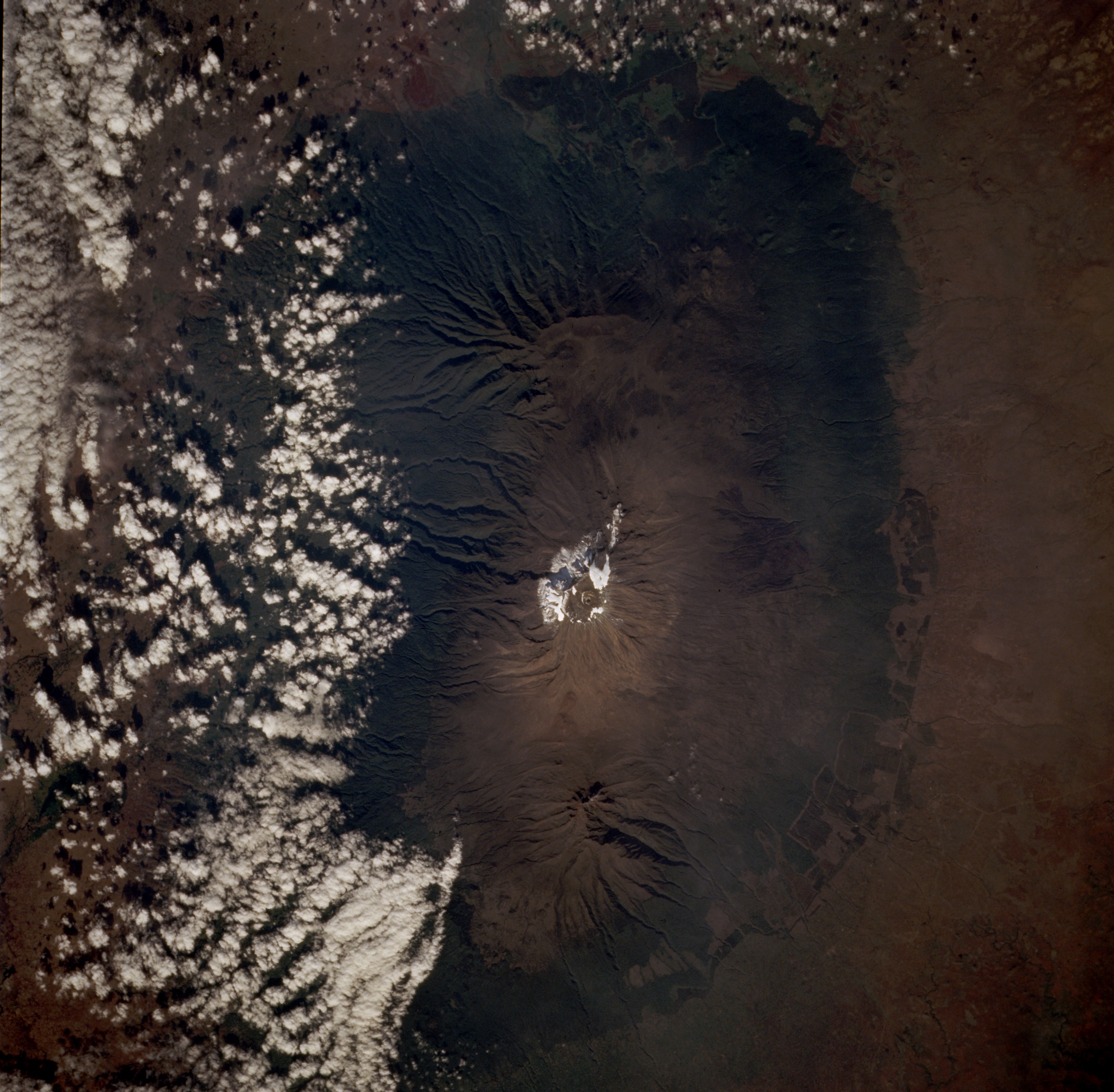
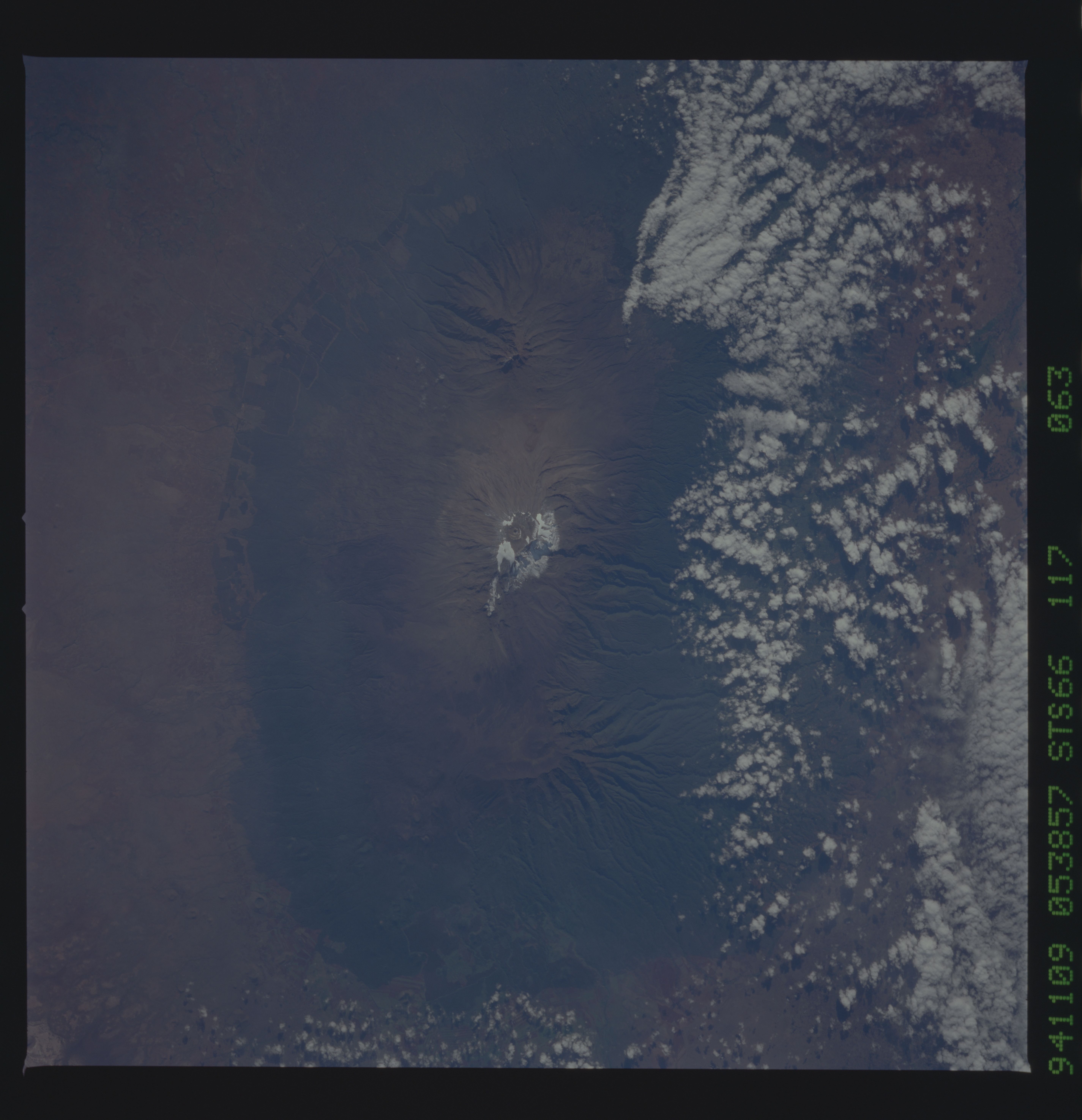
Image Caption: STS066-117-063 Mount Kilimanjaro, Tanzania November 1994
Mount Kilimanjaro, the highest [19 340 feet (5895 meters)] and most famous mountain in Africa, is located in Tanzania just adjacent to the Kenya border. Three distinct volcanoes can be seen in this near-vertical photograph--Kibo (center volcano) with the highest peak and a permanent glacier and snow field at its summit; Shira (most westerly), the oldest that has been eroded into a plateau-like feature standing 12 395 feet (3778 meters) above sea level; and Mawenzi (most easterly) with a well-defined peak that reaches 17 564 feet (5354 meters) above sea level. The overlapping lava flows from these three volcanoes have almost obliterated their individual uniqueness into a single complex volcanic feature. The southern flanks of the mountain are more deeply eroded than northern slopes. Perhaps the cloud buildup indicates the increased severity of erosion is caused by more precipitation on the southern slopes than on the northern slopes. (Refer to photograph STS-41B-046-2957, which was taken 10 years earlier, to evaluate the change in the area of ice and snow and slight changes in land use patterns near the base of the mountains.)
Mount Kilimanjaro, the highest [19 340 feet (5895 meters)] and most famous mountain in Africa, is located in Tanzania just adjacent to the Kenya border. Three distinct volcanoes can be seen in this near-vertical photograph--Kibo (center volcano) with the highest peak and a permanent glacier and snow field at its summit; Shira (most westerly), the oldest that has been eroded into a plateau-like feature standing 12 395 feet (3778 meters) above sea level; and Mawenzi (most easterly) with a well-defined peak that reaches 17 564 feet (5354 meters) above sea level. The overlapping lava flows from these three volcanoes have almost obliterated their individual uniqueness into a single complex volcanic feature. The southern flanks of the mountain are more deeply eroded than northern slopes. Perhaps the cloud buildup indicates the increased severity of erosion is caused by more precipitation on the southern slopes than on the northern slopes. (Refer to photograph STS-41B-046-2957, which was taken 10 years earlier, to evaluate the change in the area of ice and snow and slight changes in land use patterns near the base of the mountains.)
