STS064-51-25
| NASA Photo ID | STS064-51-25 |
| Focal Length | mm |
| Date taken | 1994.09.__ |
| Time taken | GMT |
Resolutions offered for this image:
3461 x 2249 pixels 640 x 415 pixels 1694 x 1106 pixels 632 x 413 pixels
3461 x 2249 pixels 640 x 415 pixels 1694 x 1106 pixels 632 x 413 pixels

Cloud masks available for this image:
Spacecraft nadir point:
Photo center point: 46.0° N, 122.0° W
Photo center point by machine learning:
Photo center point: 46.0° N, 122.0° W
Photo center point by machine learning:
Nadir to Photo Center:
Spacecraft Altitude: nautical miles (0km)
Country or Geographic Name: | USA-WASHINGTON |
Features: | MT. ST. HELENS |
| Features Found Using Machine Learning: | |
Cloud Cover Percentage: | 0 (no clouds present) |
Sun Elevation Angle: | ° |
Sun Azimuth: | ° |
Camera: | |
Focal Length: | mm |
Camera Tilt: | Near Vertical |
Format: | |
Film Exposure: | |
| Additional Information | |
| Width | Height | Annotated | Cropped | Purpose | Links |
|---|---|---|---|---|---|
| 3461 pixels | 2249 pixels | No | No | Earth From Space collection | Download Image |
| 640 pixels | 415 pixels | No | No | Earth From Space collection | Download Image |
| 1694 pixels | 1106 pixels | Earth From Space phase 2 | Download Image | ||
| 632 pixels | 413 pixels | Yes | No | Download Image |
Download Packaged File
Download a Google Earth KML for this Image
View photo footprint information
Download a GeoTIFF for this photo
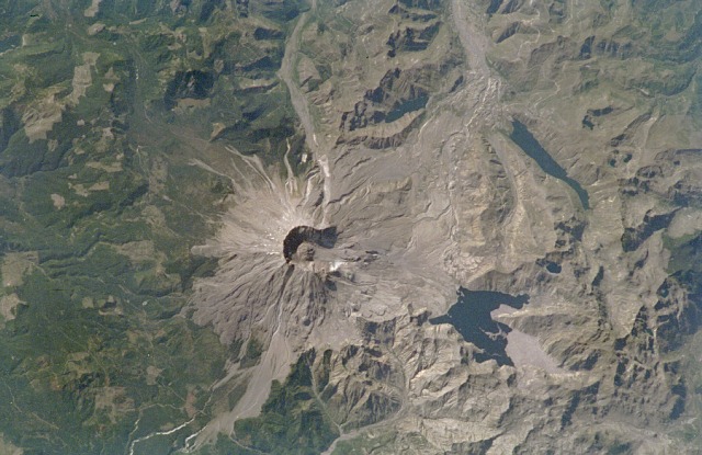
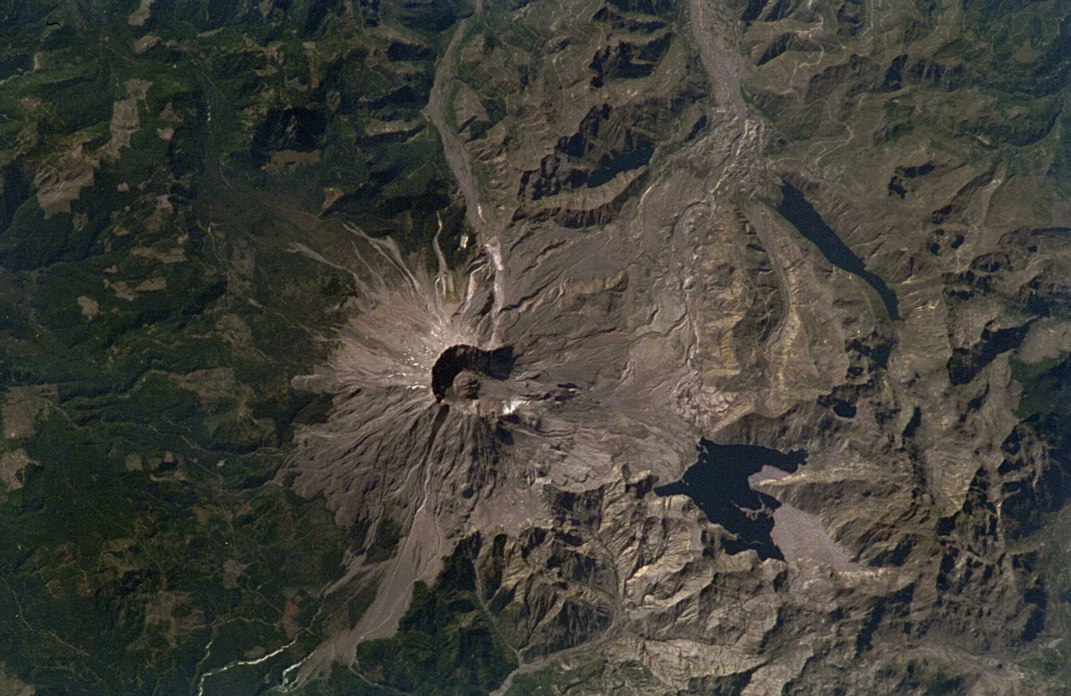
Image Caption: STS064-51-25 Mount Saint Helens National Volcanic Monument, Washington State, U.S.A. September 1994
This spectacular, near-vertical photograph taken in September 1994 shows the 8360-foot (2548-meter) Mount Saint Helens volcano with its developing lava dome and expansive pumice plain. The grayish-colored area of the blast zone from the 1980 eruption extends outward to the northwest, north, and northeast of the volcano. North of the volcano lie three major lakes from east to west--Spirit Lake (the largest), the elongated Coldwater Lake, and Castle Lake. South of Mount Saint Helens are clear-cut patterns (lumbering) interspersed throughout the darker green forested region of the Gifford Pinchot National Forest. Mount Saint Helens erupted on May 18, 1980, at 8:32 a.m. Pacific time. A series of moderate-to-severe earthquakes preceded the eruption, sending the north side of the mountain cascading downward toward Spirit Lake. This avalanche, the largest ever observed in the Western Hemisphere, weakened the magma chambers within the volcano, causing a northward lateral and vertical explosion that destroyed over 270 square miles (700 square kilometers) of forest in 5 seconds, and sent a billowing cloud of ash and smoke 70 000 feet (21 000 meters) into the atmosphere. Visible on the photograph and situated between the caldera of the volcano and Spirit Lake is a large, grayish pumice plain. This plain is made up of volcanic mud, ash, and debris that buried the original Toutle River Valley to a depth of 1000 feet (300 meters). This avalanche of debris and ash raised the level of Spirit Lake 200 feet (61 meters) over its pre-eruption level, blocked the flow of Coldwater Creek, and formed the now elongated 300-foot-deep (91-meter-deep) Coldwater Lake. This lake is located approximately 7 miles (11 kilometers) from the volcano. The lava dome, which is visible in the center of the volcano crater, has attained a height of 1700 feet (518 meters) since it began to form in the early 1980s. Though not clearly visible on the photograph, vegetation has returned and is flourishing in most areas of the blast zone, with the exception of the pumice plain area.
This spectacular, near-vertical photograph taken in September 1994 shows the 8360-foot (2548-meter) Mount Saint Helens volcano with its developing lava dome and expansive pumice plain. The grayish-colored area of the blast zone from the 1980 eruption extends outward to the northwest, north, and northeast of the volcano. North of the volcano lie three major lakes from east to west--Spirit Lake (the largest), the elongated Coldwater Lake, and Castle Lake. South of Mount Saint Helens are clear-cut patterns (lumbering) interspersed throughout the darker green forested region of the Gifford Pinchot National Forest. Mount Saint Helens erupted on May 18, 1980, at 8:32 a.m. Pacific time. A series of moderate-to-severe earthquakes preceded the eruption, sending the north side of the mountain cascading downward toward Spirit Lake. This avalanche, the largest ever observed in the Western Hemisphere, weakened the magma chambers within the volcano, causing a northward lateral and vertical explosion that destroyed over 270 square miles (700 square kilometers) of forest in 5 seconds, and sent a billowing cloud of ash and smoke 70 000 feet (21 000 meters) into the atmosphere. Visible on the photograph and situated between the caldera of the volcano and Spirit Lake is a large, grayish pumice plain. This plain is made up of volcanic mud, ash, and debris that buried the original Toutle River Valley to a depth of 1000 feet (300 meters). This avalanche of debris and ash raised the level of Spirit Lake 200 feet (61 meters) over its pre-eruption level, blocked the flow of Coldwater Creek, and formed the now elongated 300-foot-deep (91-meter-deep) Coldwater Lake. This lake is located approximately 7 miles (11 kilometers) from the volcano. The lava dome, which is visible in the center of the volcano crater, has attained a height of 1700 feet (518 meters) since it began to form in the early 1980s. Though not clearly visible on the photograph, vegetation has returned and is flourishing in most areas of the blast zone, with the exception of the pumice plain area.
