STS064-40-10
| NASA Photo ID | STS064-40-10 |
| Focal Length | mm |
| Date taken | 1994.09.__ |
| Time taken | GMT |

Cloud masks available for this image:
Spacecraft nadir point:
Photo center point: 4.5° S, 152.0° E
Photo center point by machine learning:
Photo center point: 4.5° S, 152.0° E
Photo center point by machine learning:
Nadir to Photo Center:
Spacecraft Altitude: nautical miles (0km)
Country or Geographic Name: | PAPUA NEW GUINEA |
Features: | RABAUL VOLCANO ERUPTION |
| Features Found Using Machine Learning: | |
Cloud Cover Percentage: | 60 (51-75)% |
Sun Elevation Angle: | ° |
Sun Azimuth: | ° |
Camera: | |
Focal Length: | mm |
Camera Tilt: | |
Format: | |
Film Exposure: | |
| Additional Information | |
| Width | Height | Annotated | Cropped | Purpose | Links |
|---|---|---|---|---|---|
| 3460 pixels | 2249 pixels | No | No | Earth From Space collection | Download Image |
| 639 pixels | 415 pixels | No | No | Earth From Space collection | Download Image |
Download Packaged File
Download a Google Earth KML for this Image
View photo footprint information
Download a GeoTIFF for this photo
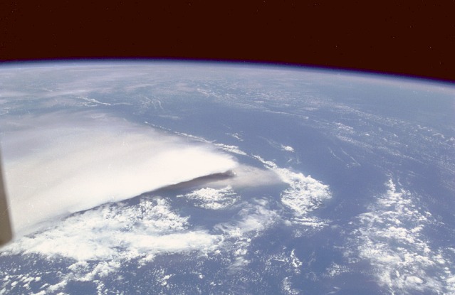
Image Caption: STS064-040-010 Rabaul Eruption Plume, New Britain Island September 1994
This high-oblique, north-northwest-looking photograph shows the eruption plume from Tavurvur and Vulcan, two volcanic cones situated on either side of the sea-filled Rabaul Volcano, located on the eastern end of New Britain Island. The white, billowing eruption plume is blowing in a westerly direction. Because of light winds at the time of the eruption, most of the 3 feet (1 meter) of ash was deposited within 12 miles (20 kilometers) of the volcanoes. Of the two eruptions in 1994, Vulcan was the more explosive, pumping a column of gas and ash more than 60 000 feet (18 000 meters) into the atmosphere. The twin eruptions, ending in December 1994, caused more than 50 000 people to flee the area. The bowl-shaped Rabaul caldera, whose diameter is 5 miles (8 kilometers), contains three additional volcanoes. The last significant eruption prior to the one captured in the photograph occurred in 1937, killing more than 500 people and virtually destroying the city of Rabaul. The present caldera was carved from the crust by a series of huge explosions occurring during the past 500 000 years. The last major explosion of the original volcano took place nearly 1400 years ago, although numerous smaller outbursts have subsequently occurred.
This high-oblique, north-northwest-looking photograph shows the eruption plume from Tavurvur and Vulcan, two volcanic cones situated on either side of the sea-filled Rabaul Volcano, located on the eastern end of New Britain Island. The white, billowing eruption plume is blowing in a westerly direction. Because of light winds at the time of the eruption, most of the 3 feet (1 meter) of ash was deposited within 12 miles (20 kilometers) of the volcanoes. Of the two eruptions in 1994, Vulcan was the more explosive, pumping a column of gas and ash more than 60 000 feet (18 000 meters) into the atmosphere. The twin eruptions, ending in December 1994, caused more than 50 000 people to flee the area. The bowl-shaped Rabaul caldera, whose diameter is 5 miles (8 kilometers), contains three additional volcanoes. The last significant eruption prior to the one captured in the photograph occurred in 1937, killing more than 500 people and virtually destroying the city of Rabaul. The present caldera was carved from the crust by a series of huge explosions occurring during the past 500 000 years. The last major explosion of the original volcano took place nearly 1400 years ago, although numerous smaller outbursts have subsequently occurred.
