STS062-97-143
| NASA Photo ID | STS062-97-143 |
| Focal Length | 40mm |
| Date taken | 1994.03.10 |
| Time taken | 17:56:15 GMT |
Resolutions offered for this image:
3925 x 3858 pixels 640 x 629 pixels 5700 x 5900 pixels 500 x 518 pixels 640 x 480 pixels
3925 x 3858 pixels 640 x 629 pixels 5700 x 5900 pixels 500 x 518 pixels 640 x 480 pixels


Cloud masks available for this image:
Spacecraft nadir point: 31.7° N, 98.1° W
Photo center point: 31.0° N, 98.5° W
Photo center point by machine learning:
Photo center point: 31.0° N, 98.5° W
Photo center point by machine learning:
Nadir to Photo Center: Southwest
Spacecraft Altitude: 161 nautical miles (298km)
Country or Geographic Name: | USA-TEXAS |
Features: | EDWARDS PLATEAU, G. COAST |
| Features Found Using Machine Learning: | |
Cloud Cover Percentage: | 5 (1-10)% |
Sun Elevation Angle: | 53° |
Sun Azimuth: | 161° |
Camera: | Hasselblad |
Focal Length: | 40mm |
Camera Tilt: | 17 degrees |
Format: | 5048: Kodak, natural color positive, Lumiere 100x/5048, ASA 100x, standard base |
Film Exposure: | Normal |
| Additional Information | |
| Width | Height | Annotated | Cropped | Purpose | Links |
|---|---|---|---|---|---|
| 3925 pixels | 3858 pixels | No | No | Earth From Space collection | Download Image |
| 640 pixels | 629 pixels | No | No | Earth From Space collection | Download Image |
| 5700 pixels | 5900 pixels | No | No | Download Image | |
| 500 pixels | 518 pixels | No | No | Download Image | |
| 640 pixels | 480 pixels | No | No | Download Image |
Download Packaged File
Download a Google Earth KML for this Image
View photo footprint information
Download a GeoTIFF for this photo
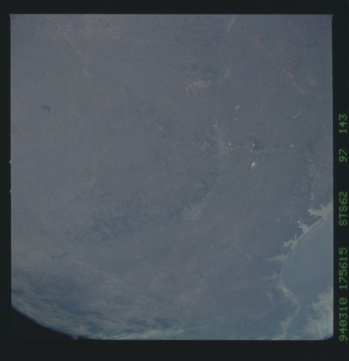
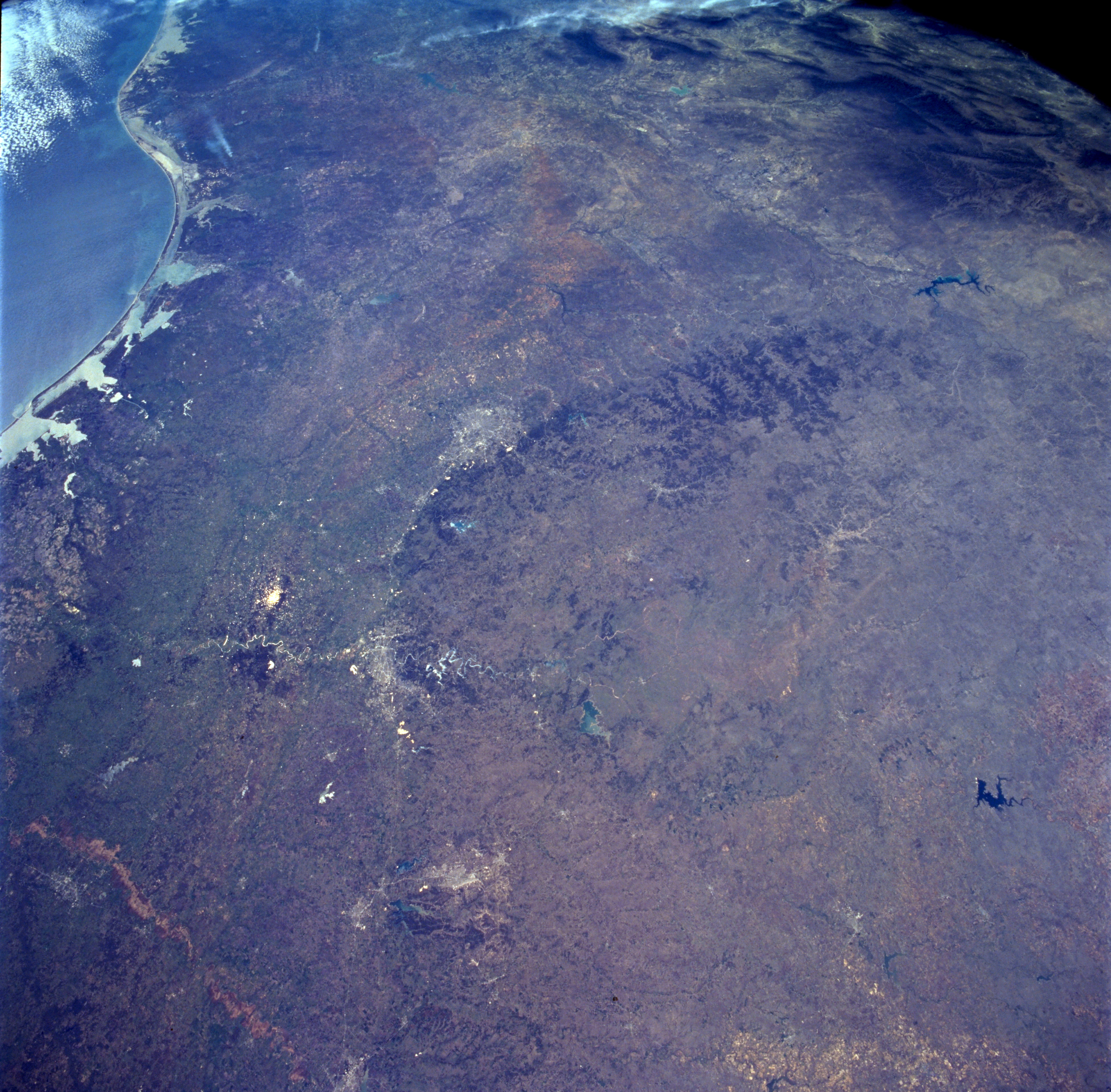
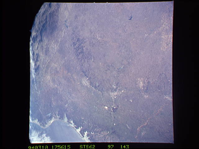
Image Caption: STS062-097-143 South-Central Texas, U.S.A. March 1994
This photograph offers a great regional view covering 500 miles (800 kilometers) from just south of Interstate Highway 20 into northeastern Mexico. Two major landforms that stand out in this low-oblique photograph of south-central Texas are the coastal plains and the Edwards Plateau. The Balcones escarpment, the boundary between the coastal plains and the Edwards Plateau, can be recognized as a gradual arc beginning in the northeast and turning more westerly as it curves along the north side of San Antonio. Beginning with San Antonio and moving generally northward, the cities (lighter areas) of Austin, bisected by the highly reflective Colorado River; Temple and Killeen with nearby Belton Lake; and Waco with Lake Waco to the west and the muddy Brazos River flowing southeast, help to identify this physical transition zone known as the Balcones escarpment. A third river system, the Rio Grande (discernible at the southwest edge of the photograph), forms the border between Texas and Mexico. Three large reservoirs are easily identified by their contrasting dark blue colors--International Amistad Reservoir (the west side of the photograph) sitting on Texas-Mexico border; Buchanan Lake northwest of Austin on the Colorado River; and Twin Butte Reservoir northwest of Buchanan Lake. Many bays and estuaries can be seen along the south Texas coast, stretching from Matagorda Bay (at the mouth of the Colorado River) south beyond Laguna Madre (at the mouth of the Rio Grande). The darker area along the southwestern corner of the photograph is part of the Sierra Madre Oriental range in Mexico.
This photograph offers a great regional view covering 500 miles (800 kilometers) from just south of Interstate Highway 20 into northeastern Mexico. Two major landforms that stand out in this low-oblique photograph of south-central Texas are the coastal plains and the Edwards Plateau. The Balcones escarpment, the boundary between the coastal plains and the Edwards Plateau, can be recognized as a gradual arc beginning in the northeast and turning more westerly as it curves along the north side of San Antonio. Beginning with San Antonio and moving generally northward, the cities (lighter areas) of Austin, bisected by the highly reflective Colorado River; Temple and Killeen with nearby Belton Lake; and Waco with Lake Waco to the west and the muddy Brazos River flowing southeast, help to identify this physical transition zone known as the Balcones escarpment. A third river system, the Rio Grande (discernible at the southwest edge of the photograph), forms the border between Texas and Mexico. Three large reservoirs are easily identified by their contrasting dark blue colors--International Amistad Reservoir (the west side of the photograph) sitting on Texas-Mexico border; Buchanan Lake northwest of Austin on the Colorado River; and Twin Butte Reservoir northwest of Buchanan Lake. Many bays and estuaries can be seen along the south Texas coast, stretching from Matagorda Bay (at the mouth of the Colorado River) south beyond Laguna Madre (at the mouth of the Rio Grande). The darker area along the southwestern corner of the photograph is part of the Sierra Madre Oriental range in Mexico.
