STS062-85-195
| NASA Photo ID | STS062-85-195 |
| Focal Length | 250mm |
| Date taken | 1994.03.09 |
| Time taken | 07:04:37 GMT |

Cloud masks available for this image:
Spacecraft nadir point: 37.5° N, 15.4° E
Photo center point: 38.0° N, 15.0° E
Photo center point by machine learning:
Photo center point: 38.0° N, 15.0° E
Photo center point by machine learning:
Nadir to Photo Center: Northwest
Spacecraft Altitude: 160 nautical miles (296km)
Camera: | Hasselblad |
Focal Length: | 250mm |
Camera Tilt: | 14 degrees |
Format: | 5046: Kodak, natural color positive, Lumiere 100/5046, ASA 100, standard base |
Film Exposure: | Normal |
| Additional Information | |
| Width | Height | Annotated | Cropped | Purpose | Links |
|---|---|---|---|---|---|
| 5700 pixels | 5900 pixels | No | No | Download Image | |
| 500 pixels | 518 pixels | No | No | Download Image | |
| 640 pixels | 480 pixels | No | No | Download Image |
Download Packaged File
Download a Google Earth KML for this Image
View photo footprint information
Download a GeoTIFF for this photo
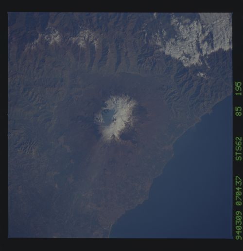
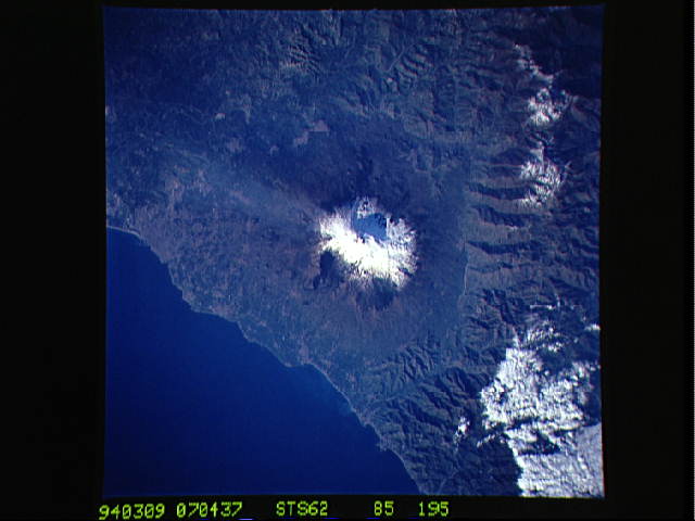
Image Caption: Mount Etna, Sicily, showing a steam plume through snow [orient with the sea to the right; then north is to the top]. Mt. Etna is Europe's largest volcano, about 60 km north-south and 40 km east-west. The elevation varies from 3260 meter to 3320 meters, depending on volcanic action. The mountain is active most of the time, at least with steam vents. More than 250 cinder cones dot the lower slopes, and lava flows threaten towns on the lower slopes every decade or so. Geological studies suggest that the cone may be several hundred thousand years old; the oldest recorded eruption was in 693 B. C. In 1169 about 15,000 people were killed in Catania by an eruption, and another large eruption in 1669 brought lava flows to the city walls. The nearly constant activity and convenient location (two hours from Rome) makes Etna a fine laboratory for international volcanological studies.
A thin plume of steam blows southward from the summit of Mt. Etna, the active volcano on the island of Sicily. The summit is capped with snow but the dark lava flow along the eastern flank (the 1991-3 flow) is clearly visible. The coastal city south of Etna is Catania.
A thin plume of steam blows southward from the summit of Mt. Etna, the active volcano on the island of Sicily. The summit is capped with snow but the dark lava flow along the eastern flank (the 1991-3 flow) is clearly visible. The coastal city south of Etna is Catania.
