STS062-83-48

| NASA Photo ID | STS062-83-48 |
| Focal Length | 250mm |
| Date taken | 1994.03.05 |
| Time taken | 18:49:04 GMT |
Resolutions offered for this image:
3904 x 3904 pixels 639 x 639 pixels 5700 x 5900 pixels 500 x 518 pixels 640 x 480 pixels
3904 x 3904 pixels 639 x 639 pixels 5700 x 5900 pixels 500 x 518 pixels 640 x 480 pixels

Cloud masks available for this image:
Spacecraft nadir point: 37.9° N, 97.3° W
Photo center point: 36.5° N, 97.0° W
Photo center point by machine learning:
Photo center point: 36.5° N, 97.0° W
Photo center point by machine learning:
Nadir to Photo Center: South
Spacecraft Altitude: 161 nautical miles (298km)
Country or Geographic Name: | USA-OKLAHOMA |
Features: | PONCA CITY, R, FLINT HILLS |
| Features Found Using Machine Learning: | |
Cloud Cover Percentage: | 0 (no clouds present) |
Sun Elevation Angle: | 46° |
Sun Azimuth: | 183° |
Camera: | Hasselblad |
Focal Length: | 250mm |
Camera Tilt: | 28 degrees |
Format: | 5046: Kodak, natural color positive, Lumiere 100/5046, ASA 100, standard base |
Film Exposure: | Normal |
| Additional Information | |
| Width | Height | Annotated | Cropped | Purpose | Links |
|---|---|---|---|---|---|
| 3904 pixels | 3904 pixels | No | No | Earth From Space collection | Download Image |
| 639 pixels | 639 pixels | No | No | Earth From Space collection | Download Image |
| 5700 pixels | 5900 pixels | No | No | Download Image | |
| 500 pixels | 518 pixels | No | No | Download Image | |
| 640 pixels | 480 pixels | No | No | Download Image |
Download Packaged File
Download a Google Earth KML for this Image
View photo footprint information
Download a GeoTIFF for this photo
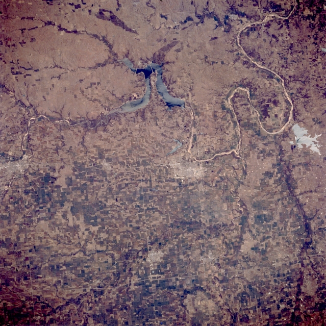
Image Caption: STS062-083-048 Ponca City, Arkansas River, and Kaw Lake, Oklahoma, U.S.A. March 1994
This east-looking, low-oblique photograph features the Arkansas River as it meanders generally southeastward from Arkansas City, Kansas, (left center) through Kaw Lake, past Ponca City and Sooner Lake, toward Tulsa (upper right). Ponca City, founded in 1893 after the opening of the Oklahoma Territory in 1889, is a trade, processing, and shipping hub in a grain, livestock, and oil area. Other manufactures include clothing, oil drilling equipment, and food processing products. Visible are the extreme southern portions of the gently rolling, grass-covered Flint Hills (upper left).
This east-looking, low-oblique photograph features the Arkansas River as it meanders generally southeastward from Arkansas City, Kansas, (left center) through Kaw Lake, past Ponca City and Sooner Lake, toward Tulsa (upper right). Ponca City, founded in 1893 after the opening of the Oklahoma Territory in 1889, is a trade, processing, and shipping hub in a grain, livestock, and oil area. Other manufactures include clothing, oil drilling equipment, and food processing products. Visible are the extreme southern portions of the gently rolling, grass-covered Flint Hills (upper left).
