STS062-152-252
| NASA Photo ID | STS062-152-252 |
| Focal Length | 250mm |
| Date taken | 1994.03.10 |
| Time taken | 17:57:08 GMT |

Cloud masks available for this image:
Spacecraft nadir point: 30.3° N, 95.0° W
Photo center point: 30.0° N, 95.5° W
Photo center point by machine learning:
Photo center point: 30.0° N, 95.5° W
Photo center point by machine learning:
Nadir to Photo Center: Southwest
Spacecraft Altitude: 161 nautical miles (298km)
Country or Geographic Name: | USA-TEXAS |
Features: | NORTH HOUSTON AREA, LAKE HOUSTON, CONROE |
| Features Found Using Machine Learning: | |
Cloud Cover Percentage: | 0 (no clouds present) |
Sun Elevation Angle: | 55° |
Sun Azimuth: | 166° |
Camera: | Linhof |
Focal Length: | 250mm |
Camera Tilt: | 12 degrees |
Format: | 5046: Kodak, natural color positive, Lumiere 100/5046, ASA 100, standard base |
Film Exposure: | Normal |
| Additional Information | |
| Width | Height | Annotated | Cropped | Purpose | Links |
|---|---|---|---|---|---|
| 5184 pixels | 4096 pixels | No | No | Earth From Space collection | Download Image |
| 640 pixels | 505 pixels | No | No | Earth From Space collection | Download Image |
| 640 pixels | 480 pixels | No | No | ISD 1 | Download Image |
Download Packaged File
Download a Google Earth KML for this Image
View photo footprint information
Download a GeoTIFF for this photo
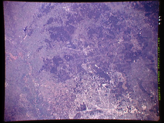
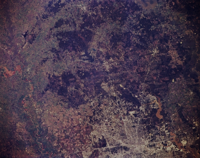
Image Caption: STS062-152-252 North Houston, Texas, U.S.A. March 1994
The landscape outside metropolitan Houston consists of flat coastal plains and rolling grasslands west and northwest of the city and darker, dense stands of vegetation, primarily pine forests, to the north. Several highway systems radiate from Houston--Interstate Highway 45 northward from central Houston through Conroe and Huntsville toward Dallas; U.S. Highway 59 to the northeast; and U.S. Highway 290 to the northwest. Apparent north of Houston are the V-shaped runways of Bush Intercontinental Airport with muddy Lake Houston to its east and Lake Conroe, northwest of Conroe, with brown sediment in its northern reaches. Visible are small, dark Gibbons Creek Lake; a segment of the southeast-flowing Brazos River and its floodplain; and a small area of cultivated fields between western Houston and the Brazos River.
The landscape outside metropolitan Houston consists of flat coastal plains and rolling grasslands west and northwest of the city and darker, dense stands of vegetation, primarily pine forests, to the north. Several highway systems radiate from Houston--Interstate Highway 45 northward from central Houston through Conroe and Huntsville toward Dallas; U.S. Highway 59 to the northeast; and U.S. Highway 290 to the northwest. Apparent north of Houston are the V-shaped runways of Bush Intercontinental Airport with muddy Lake Houston to its east and Lake Conroe, northwest of Conroe, with brown sediment in its northern reaches. Visible are small, dark Gibbons Creek Lake; a segment of the southeast-flowing Brazos River and its floodplain; and a small area of cultivated fields between western Houston and the Brazos River.
